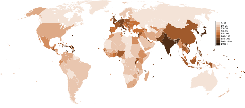
Datoteka:Countries by population density.svg

Veličina ovog PNG pregleda za ovu SVG datoteku: 800 × 353 piksela. Ostale rezolucije: 320 × 141 piksela | 640 × 282 piksela | 1.024 × 452 piksela | 1.280 × 565 piksela | 2.560 × 1.129 piksela | 6.000 × 2.647 piksela.
Izvorna datoteka (SVG datoteka, nominalno 6.000 × 2.647 piksela, veličina datoteke: 1,62 MB)
Historija datoteke
Kliknite na datum/vrijeme da vidite verziju datoteke iz tog vremena.
| Datum/vrijeme | Smanjeni pregled | Dimenzije | Korisnik | Komentar | |
|---|---|---|---|---|---|
| trenutno | 01:33, 22 decembar 2011 |  | 6.000 × 2.647 (1,62 MB) | Quibik | added transparency |
| 15:43, 20 februar 2011 |  | 6.000 × 2.647 (1,62 MB) | Erik del Toro Streb | typographically corrected | |
| 04:22, 7 januar 2008 |  | 6.000 × 2.647 (1,62 MB) | Briefplan~commonswiki | {{Information |Description=A map of the world, with colours to highlight the population density of each country or territory. Numbers on the legend are in people per km<sup>2</sup>, and all countries smaller than 20,000 km<sup>2</sup> are represented by a |
Upotreba datoteke
Sljedeća stranica koristi ovu datoteku:
Globalna upotreba datoteke
Sljedeći wikiji koriste ovu datoteku:
- Upotreba na af.wikipedia.org
- Upotreba na ar.wikipedia.org
- Upotreba na arz.wikipedia.org
- Upotreba na ast.wikipedia.org
- Upotreba na av.wikipedia.org
- Upotreba na awa.wikipedia.org
- Upotreba na azb.wikipedia.org
- Upotreba na az.wikipedia.org
- Upotreba na ba.wikipedia.org
- Upotreba na be.wikipedia.org
- Upotreba na bg.wikipedia.org
- Upotreba na ca.wikipedia.org
- Upotreba na ckb.wikipedia.org
- Upotreba na cs.wikipedia.org
- Upotreba na cy.wikipedia.org
- Upotreba na de.wikipedia.org
- Upotreba na de.wikiversity.org
- Upotreba na diq.wikipedia.org
- Upotreba na dsb.wikipedia.org
- Upotreba na en.wikipedia.org
- Upotreba na eo.wikipedia.org
- Upotreba na es.wikipedia.org
- Upotreba na eu.wikipedia.org
- Upotreba na fi.wikipedia.org
- Upotreba na fr.wikipedia.org
- Upotreba na gl.wikipedia.org
Pogledajte globalne upotrebe ove datoteke.
