
Datoteka:Cyclone Agni.jpg

Veličina ovog prikaza: 711 × 600 piksela. Ostale rezolucije: 285 × 240 piksela | 569 × 480 piksela.
Izvorna datoteka (800 × 675 piksela, veličina datoteke: 155 KB, MIME tip: image/jpeg)
| Ova datoteka je s Wikimedia Commonsa. Opis s njene stranice opisa datoteke prikazan je ispod. Commons je skladište slobodnih medija i datoteka za sve projekte fondacije Wikimedia. Možete i Vi pomoći. |
Sažetak
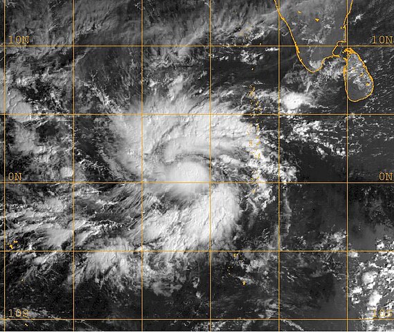
| Opis | This MET-5 visible satellite image taken at 0400 UTC shows Agni as a developing tropical storm just north of the equator. | ||||||
| Datum | |||||||
| Izvor | http://www.nrlmry.navy.mil/tc_pages/tc_home.html | ||||||
| Autor | Naval Research Laboratory | ||||||
| Dopuštenje (Naknadno korištenje ove datoteke) |
|
||||||
Licenciranje
This file is a work of a sailor or employee of the U.S. Navy, taken or made as part of that person's official duties. As a work of the U.S. federal government, it is in the public domain in the United States.
|
 | |
| Ova datoteka je identificirana kao slobodna od poznatih ograničenja po zakonu o autorskim pravima, uključujući sva povezana i srodna prava. | ||
Historija datoteke
Kliknite na datum/vrijeme da vidite verziju datoteke iz tog vremena.
| Datum/vrijeme | Smanjeni pregled | Dimenzije | Korisnik | Komentar | |
|---|---|---|---|---|---|
| trenutno | 11:04, 12 oktobar 2006 | | 800 × 675 (155 KB) | NSLE-Chacor | Higher-res image from NRL ([http://www.nrlmry.navy.mil/tc-bin/tc_display.cgi?BASIN=IO&STORM_NAME=05A.AGNI&ACTION=Latest_Photos&ACTIVES=None&MOSAIC_SCALE=20&PHOT=yes&ATCF_BASIN=io&CGI=TC&AGE=Prev&ARCHIVE=all&NAV=tc&YR=04&ATCF_YR=2004&YEAR=2004&ATCF_FILE=/d |
| 05:00, 16 decembar 2005 |  | 495 × 413 (63 KB) | Hurricanehink | From the JTWC Cyclone Agni report at https://metoc.npmoc.navy.mil/jtwc/atcr/2004atcr/, this MET-5 visible satellite image shows Agni as a developing tropical storm just north of the equator. |
Upotreba datoteke
Sljedeća stranica koristi ovu datoteku:
Globalna upotreba datoteke
Sljedeći wikiji koriste ovu datoteku:
- Upotreba na en.wikipedia.org
- Upotreba na pt.wikipedia.org
- Upotreba na zh.wikipedia.org