
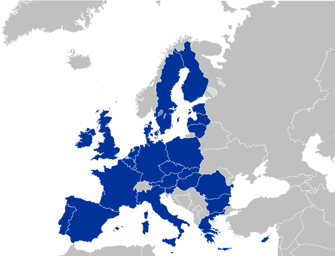
Datoteka:EU27-2008 European Union map.svg

Veličina ovog PNG pregleda za ovu SVG datoteku: 680 × 520 piksela. Ostale rezolucije: 314 × 240 piksela | 628 × 480 piksela | 1.004 × 768 piksela | 1.280 × 979 piksela | 2.560 × 1.958 piksela.
Izvorna datoteka (SVG datoteka, nominalno 680 × 520 piksela, veličina datoteke: 319 KB)
| Ova datoteka je s Wikimedia Commonsa. Opis s njene stranice opisa datoteke prikazan je ispod. Commons je skladište slobodnih medija i datoteka za sve projekte fondacije Wikimedia. Možete i Vi pomoći. |
Sažetak
| Opis |
Deutsch:
Español:
Français :
Italiano: |
| Datum | (UTC) |
| Izvor | |
| Autor |
|
| Ostale verzije |
|


EU-Farbschema / EU color scheme
- Europe blue / Europablau / azul europeo / bleu européenne (Pantone; RGB 003399): EU current members
- Regent St Blue (RAL 6034; RGB 9ac0cd): Transition period (see Brexit withdrawal agreement)
- Pantone yellow / Gelb / amarillo / jaune (Pantone; RGB ffcc00): EU new members
- Light blue / Lichtblau / azul claro / bleu clair (RGB 2782bb): EU candidate countries
- Light green / Lichtgrün / verde claro / vert clair (RGB 77bbbc): EU potential candidate countries
- Lawngreen / Grasgrün / verde hierba / vert pré (RGB a0e200): EU membership possible
- Orange / Orange / anaranjado / orange (RGB ff6600): Eastern Partnership
- Emerald green / Smaragdgrün / verde esmeralda / smaragdin (RAL 6001; RGB 276d3a): EFTA member states
- Pastel green / Weißgrün / verde blanquecino / vert blanc (RAL 6019; RGB b3d9b4): EFTA former member states
Licenciranje
Ja, vlasnik autorskog prava ovog djela, ovdje ga objavljujem pod sljedećom licencom:
Ova datoteka je licencirana pod Creative Commons Attribution-Share Alike 2.5 generičkom licencom.
- Slobodni ste:
- da dijelite – da kopirate, distributirate i prenosite djelo
- da remiksate – da prilagodite djelo
- Pod sljedećim uslovima:
- pripisivanje – Morate pripisati odgovarajuće autorske zasluge, osigurati link ka licenci i naznačiti jesu li napravljene izmjene. To možete uraditi na bilo koji razumni način, ali ne tako da se sugerira da davalac licence odobrava Vas ili Vašu upotrebu njegovog djela.
- dijeli pod istim uslovima – Ako mijenjate, transformišete ili nadograđujete ovaj materijal, morate ga objaviti i distribuirati samo pod istom ili sličnom licencom poput ove.
Originalni zapisnik postavljanja
This image is a derivative work of the following images:
- File:Europe_countries.svg licensed with Cc-by-sa-2.5, Cc-by-sa-2.5/de
- 2009-02-08T23:17:13Z Kolja21 800x520 (564619 Bytes) Rev. Montenegro was deleted
- 2009-02-03T09:39:06Z Koyos 800x520 (548987 Bytes) This map is more accurate, supported by more sources
- 2008-07-24T10:36:24Z Aegean Boy 800x520 (564619 Bytes)
- 2006-05-23T10:51:14Z Tintazul 800x520 (548987 Bytes) {{Tintazul| |Description=Blank map of Europe, showing national borders. SVG format. Includes Kazakhstan. |Date=19 May 2006 }} [[Category:Maps of Europe]]
Uploaded with derivativeFX
Historija datoteke
Kliknite na datum/vrijeme da vidite verziju datoteke iz tog vremena.
| Datum/vrijeme | Smanjeni pregled | Dimenzije | Korisnik | Komentar | |
|---|---|---|---|---|---|
| trenutno | 22:36, 26 april 2010 | | 680 × 520 (319 KB) | Quibik | Fixed some of the lakes not displaying correctly off-wiki. |
| 01:13, 26 april 2010 |  | 680 × 520 (319 KB) | Quibik | another try... | |
| 01:12, 26 april 2010 |  | 680 × 520 (319 KB) | Quibik | Trying a RSVG's CSS bug workaround. | |
| 01:09, 26 april 2010 |  | 680 × 520 (318 KB) | Quibik | Restored the country id-s that went missing with my edit. Also, RSVG displayed the border thicknesses of EU countries wrongly. | |
| 16:30, 20 april 2010 |  | 680 × 520 (330 KB) | Quibik | optimized the source code | |
| 21:39, 10 maj 2009 |  | 680 × 520 (519 KB) | Kolja21 | Minor edit: Grenzverlauf optimiert | |
| 02:28, 10 maj 2009 |  | 680 × 520 (518 KB) | Kolja21 | Minor edit: Grenzverlauf optimiert | |
| 19:25, 4 maj 2009 |  | 680 × 520 (518 KB) | Kolja21 | Isle of Man (IM; till April 2007: GB-IOM) is not part of the EU | |
| 03:10, 4 maj 2009 |  | 680 × 520 (518 KB) | Kolja21 | Malta | |
| 21:14, 30 april 2009 |  | 680 × 520 (515 KB) | Kolja21 | == Summary == {{Information |Description= {{en|1=European Union (EU 27)}} {{legend|#003399|Current members}} {{de|1=Europäische Union (EU 27)}} {{legend|#003399|Mitgliedstaaten}} {{es|1=Unión Europea (UE 27)}} {{legend|#003399|Estados miembros}} |
Upotreba datoteke
Nema stranica koje koriste ovu datoteku.
Globalna upotreba datoteke
Sljedeći wikiji koriste ovu datoteku:
- Upotreba na de.wikipedia.org
- Upotreba na fr.wikinews.org
- Upotreba na hu.wikipedia.org
- Upotreba na mk.wikipedia.org
- Upotreba na pl.wiktionary.org
- Upotreba na pt.wikipedia.org