Datoteka:Lagrange points.jpg

Veličina ovog prikaza: 685 × 599 piksela. Ostale rezolucije: 274 × 240 piksela | 549 × 480 piksela | 878 × 768 piksela | 1.170 × 1.024 piksela | 2.400 × 2.100 piksela.
Izvorna datoteka (2.400 × 2.100 piksela, veličina datoteke: 709 KB, MIME tip: image/jpeg)
Historija datoteke
Kliknite na datum/vrijeme da vidite verziju datoteke iz tog vremena.
| Datum/vrijeme | Smanjeni pregled | Dimenzije | Korisnik | Komentar | |
|---|---|---|---|---|---|
| trenutno | 01:35, 17 mart 2011 |  | 2.400 × 2.100 (709 KB) | Antonsusi | Higher resolution |
| 17:12, 5 februar 2007 |  | 489 × 419 (62 KB) | EnEdC | also move L4, L5 out | |
| 02:37, 29 juni 2006 |  | 489 × 419 (62 KB) | EnEdC | Moved L3 left slightly. | |
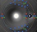
| 19:53, 31 mart 2006 |  | 479 × 419 (49 KB) | Mlm42~commonswiki | A contour plot of the effective potential of a two-body system. It clearly shows the 5-lagrange points. |
Upotreba datoteke
Sljedeća stranica koristi ovu datoteku:
Globalna upotreba datoteke
Sljedeći wikiji koriste ovu datoteku:
- Upotreba na ar.wikipedia.org
- Upotreba na arz.wikipedia.org
- Upotreba na ca.wikipedia.org
- Upotreba na cs.wikipedia.org
- Upotreba na cv.wikipedia.org
- Upotreba na da.wikipedia.org
- Upotreba na de.wikipedia.org
- Upotreba na de.wikibooks.org
- Upotreba na en.wikipedia.org
- Upotreba na eo.wikipedia.org
- Upotreba na es.wikipedia.org
- Upotreba na et.wikipedia.org
- Upotreba na fa.wikipedia.org
- Upotreba na fi.wikipedia.org
- Upotreba na fr.wikipedia.org
- Orbite
- Satellite artificiel
- Planck (télescope spatial)
- Herschel (télescope spatial)
- Portail:Astronautique
- Portail:Astronautique/Articles
- Utilisateur:Wikisoft*/Astronautique
- Colonisation de l'espace
- Utilisateur:Pline/Portail:astronautique
- Utilisateur:Pline/Portail:Astronautique/Articles
- Utilisateur:MG/Page20
- Colonisation des points de Lagrange
- Upotreba na he.wikipedia.org
- Upotreba na hu.wikipedia.org
- Upotreba na hy.wikipedia.org
- Upotreba na ja.wikipedia.org
Pogledajte globalne upotrebe ove datoteke.


