
Datoteka:Nya Sverige.svg

Veličina ovog PNG pregleda za ovu SVG datoteku: 342 × 599 piksela. Ostale rezolucije: 137 × 240 piksela | 274 × 480 piksela | 439 × 768 piksela | 585 × 1.024 piksela | 1.170 × 2.048 piksela | 720 × 1.260 piksela.
Izvorna datoteka (SVG datoteka, nominalno 720 × 1.260 piksela, veličina datoteke: 461 KB)
| Ova datoteka je s Wikimedia Commonsa. Opis s njene stranice opisa datoteke prikazan je ispod. Commons je skladište slobodnih medija i datoteka za sve projekte fondacije Wikimedia. Možete i Vi pomoći. |
Sažetak
| Opis |
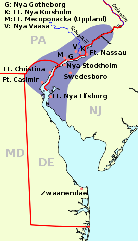
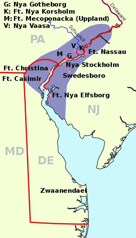
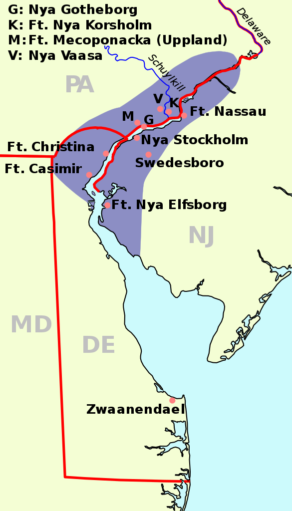
English: The map of New Sweden, 1638 Deutsch: Karte von Neu-Schweden, 1638. Русский: Карта Новой Швеции, 1638 год |
||
| Datum | (UTC) | ||
| Izvor | |||
| Autor |
|
||
| SVG genesis | This map was created with a text editor.
|
| See also: Nieuw Nederland and Nya Sverige |
Ova datoteka je licencirana pod Creative Commons Attribution-Share Alike 3.0 neportiranom licencom.
- Slobodni ste:
- da dijelite – da kopirate, distributirate i prenosite djelo
- da remiksate – da prilagodite djelo
- Pod sljedećim uslovima:
- pripisivanje – Morate pripisati odgovarajuće autorske zasluge, osigurati link ka licenci i naznačiti jesu li napravljene izmjene. To možete uraditi na bilo koji razumni način, ali ne tako da se sugerira da davalac licence odobrava Vas ili Vašu upotrebu njegovog djela.
- dijeli pod istim uslovima – Ako mijenjate, transformišete ili nadograđujete ovaj materijal, morate ga objaviti i distribuirati samo pod istom ili sličnom licencom poput ove.
Originalni zapisnik postavljanja
This image is a derivative work of the following images:
- File:Nya Sverige.png licensed with Cc-by-sa-3.0-migrated, GFDL, PD-self
- 2005-10-12T00:50:54Z Arnapha 306x528 (6492 Bytes) Map of New-Sweden ca. 1650 Created on base of the maps of Delaware and New Jersey from the Perry Castañeda Library (at http://www.lib.utexas.edu/maps/united_states.html). Transferred from German Wikipedia (http://de.wikipe
- File:USA New Jersey location map.svg licensed with Cc-by-3.0, GFDL
- 2009-06-17T19:59:27Z Alexrk2 839x1560 (259806 Bytes) enh
- 2009-06-13T18:01:16Z Alexrk 839x1560 (198653 Bytes) fixed SVG bug
- 2009-06-13T17:46:17Z Alexrk 839x1560 (246056 Bytes) == Beschreibung == {{Information |Description= {{de|Positionskarte von [[:de:New Jersey|New Jersey]], [[:de:USA|USA]]}} Quadratische Plattkarte, N-S-Streckung 130.0 %. Geographische Begrenzung der Karte: * N: 41.6° N * S: 38
- File:USA New York location map.svg licensed with Cc-by-3.0, GFDL
- 2009-06-10T11:28:20Z NordNordWest 1572x1277 (597043 Bytes) {{Information |Description= {{de|Positionskarte vom Bundesstaat [[:de:New York (Bundesstaat)|New York]], [[:de:USA|USA]]}} Quadratische Plattkarte, N-S-Streckung 135 %. Geographische Begrenzung der Karte: * N: 45.3° N * S: 4
- File:USA Delaware location map.svg licensed with Cc-by-3.0, GFDL
- 2009-06-22T10:54:18Z Alexrk2 470x800 (106507 Bytes) renderer bug
- 2009-06-22T10:39:54Z Alexrk2 470x800 (66078 Bytes) == Beschreibung == {{Information |Description= {{de|Positionskarte von [[:de:Delaware|Delaware]], [[:de:USA|USA]]}} Quadratische Plattkarte, N-S-Streckung 130.0 %. Geographische Begrenzung der Karte: * N: 40.0° N * S: 38.3°
Uploaded with derivativeFX
Historija datoteke
Kliknite na datum/vrijeme da vidite verziju datoteke iz tog vremena.
| Datum/vrijeme | Smanjeni pregled | Dimenzije | Korisnik | Komentar | |
|---|---|---|---|---|---|
| trenutno | 10:23, 1 januar 2011 | | 720 × 1.260 (461 KB) | Arnapha | adapted size |
| 08:05, 1 januar 2011 |  | 730 × 1.270 (461 KB) | Arnapha | moved origin | |
| 08:01, 1 januar 2011 |  | 730 × 1.270 (461 KB) | Arnapha | use total viewBox | |
| 07:12, 1 januar 2011 |  | 1.020 × 1.760 (461 KB) | Arnapha | text position | |
| 06:18, 1 januar 2011 |  | 1.020 × 1.760 (461 KB) | Arnapha | removed unused items | |
| 04:26, 1 januar 2011 |  | 1.020 × 1.760 (644 KB) | Arnapha | {{Information |Description={{en|The map of New Sweden, 1638. Created on base of the maps of Delaware and New Jersey from the Perry Castañeda Library (at [http://www.lib.utexas.edu/maps/united_states.html www.lib.utexas.edu]).}} {{de|Karte von Neu-Schwede |
Upotreba datoteke
Sljedeća stranica koristi ovu datoteku:
Globalna upotreba datoteke
Sljedeći wikiji koriste ovu datoteku:
- Upotreba na af.wikipedia.org
- Upotreba na azb.wikipedia.org
- Upotreba na be.wikipedia.org
- Upotreba na bg.wikipedia.org
- Upotreba na ca.wikipedia.org
- Upotreba na cs.wikipedia.org
- Upotreba na da.wikipedia.org
- Upotreba na de.wikipedia.org
- Upotreba na en.wikipedia.org
- Upotreba na es.wikipedia.org
- Upotreba na fi.wikipedia.org
- Upotreba na fr.wikipedia.org
- Upotreba na fy.wikipedia.org
- Upotreba na he.wikipedia.org
- Upotreba na hr.wikipedia.org
- Upotreba na hu.wikipedia.org
- Upotreba na io.wikipedia.org
- Upotreba na it.wikipedia.org
- Upotreba na li.wikipedia.org
- Upotreba na nds.wikipedia.org
- Upotreba na nl.wikipedia.org
- Upotreba na no.wikipedia.org
- Upotreba na pl.wikipedia.org
- Upotreba na pt.wikipedia.org
- Upotreba na ru.wikipedia.org
- Upotreba na sh.wikipedia.org
- Upotreba na sr.wikipedia.org
- Upotreba na sv.wikipedia.org
Pogledajte globalne upotrebe ove datoteke.