
Datoteka:Ocean gravity map.gif
Veličina ovog prikaza: 800 × 473 piksela. Ostale rezolucije: 320 × 189 piksela | 640 × 378 piksela | 1.010 × 597 piksela.
Izvorna datoteka (1.010 × 597 piksela, veličina datoteke: 466 KB, MIME tip: image/gif)
| Ova datoteka je s Wikimedia Commonsa. Opis s njene stranice opisa datoteke prikazan je ispod. Commons je skladište slobodnih medija i datoteka za sve projekte fondacije Wikimedia. Možete i Vi pomoći. |
| Opis |
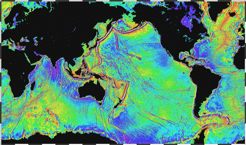
English: Ocean basins mapped with satellite altimetry. Seafloor features larger than 10 km are detected by resulting gravitational distortion of sea surface. |
| Datum | |
| Izvor | http://www.ngdc.noaa.gov/mgg/bathymetry/predicted/explore.HTML |
| Autor | NOAA |
This image is in the public domain because it contains materials that originally came from the U.S. National Oceanic and Atmospheric Administration, taken or made as part of an employee's official duties.
|
Historija datoteke
Kliknite na datum/vrijeme da vidite verziju datoteke iz tog vremena.
| Datum/vrijeme | Smanjeni pregled | Dimenzije | Korisnik | Komentar | |
|---|---|---|---|---|---|
| trenutno | 00:18, 4 april 2006 | | 1.010 × 597 (466 KB) | Korrigan | Ocean basins mapped with satellite altimetry. Seafloor features larger than 10 km are detected by resulting gravitational distortion of sea surface. Source: http://www.ngdc.noaa.gov/mgg/bathymetry/predicted/explore.HTML {{PD-USGov-DOC-NOAA}} [[Cate |
| 22:36, 19 mart 2006 |  | 1.010 × 597 (196 KB) | Maksim | La bildo estas kopiita de wikipedia:en. La originala priskribo estas: Ocean basins mapped with satellite altimetry. Seafloor features larger than 10 km are detected by resulting gravitational distortion of sea surface. Source: http://www.ngdc.noaa.go |
Upotreba datoteke
Sljedeća stranica koristi ovu datoteku:
Globalna upotreba datoteke
Sljedeći wikiji koriste ovu datoteku:
- Upotreba na bxr.wikipedia.org
- Upotreba na cs.wikipedia.org
- Upotreba na de.wikipedia.org
- Upotreba na el.wikipedia.org
- Upotreba na en.wikipedia.org
- Upotreba na eo.wikipedia.org
- Upotreba na es.wikipedia.org
- Upotreba na et.wikipedia.org
- Upotreba na fi.wikipedia.org
- Upotreba na fo.wikipedia.org
- Upotreba na fr.wikipedia.org
- Upotreba na fr.wiktionary.org
- Upotreba na gd.wikipedia.org
- Upotreba na gl.wikipedia.org
- Upotreba na gu.wikipedia.org
- Upotreba na he.wikipedia.org
- Upotreba na hi.wikipedia.org
- Upotreba na hr.wikipedia.org
- Upotreba na ht.wikipedia.org
- Upotreba na hy.wikipedia.org
- Upotreba na hyw.wikipedia.org
- Upotreba na ja.wikipedia.org
- Upotreba na kk.wikipedia.org
- Upotreba na la.wikipedia.org
- Upotreba na lv.wikipedia.org
- Upotreba na mn.wikipedia.org
- Upotreba na ru.wikipedia.org
- Upotreba na scn.wikipedia.org
- Upotreba na sh.wikipedia.org
- Upotreba na sl.wikipedia.org
- Upotreba na sv.wikipedia.org
- Upotreba na ta.wikipedia.org
- Upotreba na te.wikipedia.org
Pogledajte globalne upotrebe ove datoteke.