
Datoteka:Slovakia1941 02.png
Veličina ovog prikaza: 794 × 600 piksela. Ostale rezolucije: 318 × 240 piksela | 636 × 480 piksela | 997 × 753 piksela.
Izvorna datoteka (997 × 753 piksela, veličina datoteke: 50 KB, MIME tip: image/png)
| Ova datoteka je s Wikimedia Commonsa. Opis s njene stranice opisa datoteke prikazan je ispod. Commons je skladište slobodnih medija i datoteka za sve projekte fondacije Wikimedia. Možete i Vi pomoći. |
Sažetak
| Opis |
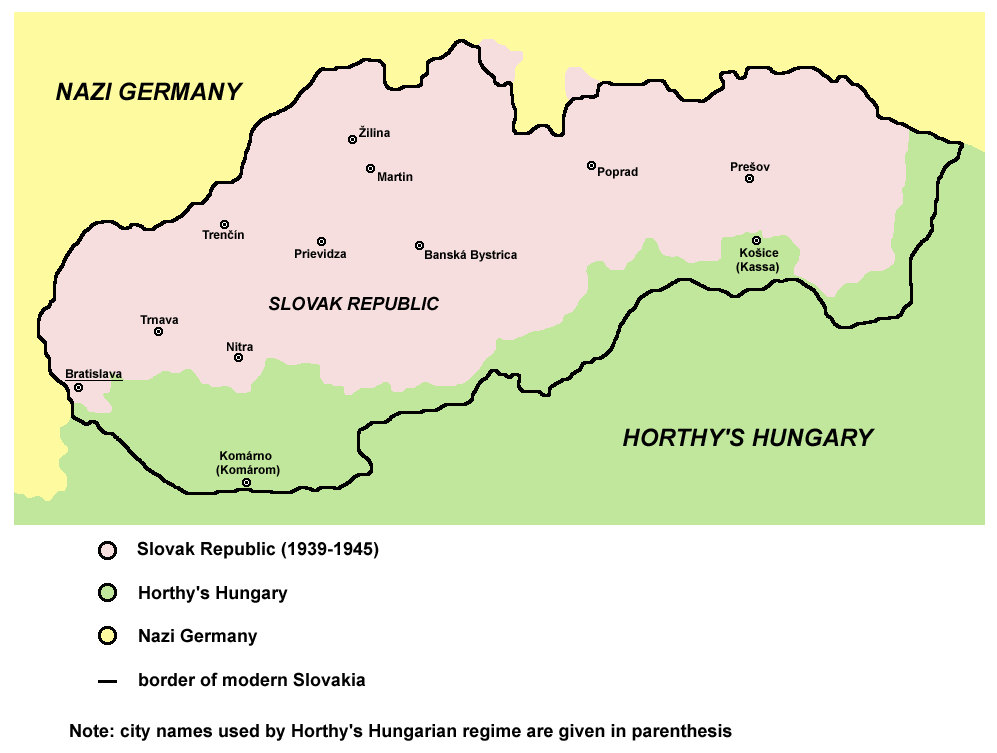
English: historic map of Slovak Republic (1939-1945) |
| Datum | 28 decembar 2006 (original upload date) |
| Izvor | Vlastito djelo |
| Autor | PANONIAN |
| Ostale verzije |
[]
|


.png)

References
Published references:
- The Times History of Europe, Times Books, London, 2002.
- Richard Overy, The Times History of the 20th Century, Times Books, London, 2003.
- Istorijski atlas, Zavod za udžbenike i nastavna sredstva - Zavod za kartografiju "Geokarta", Beograd, 1999.
- Peter Rokai - Zoltan Đere - Tibor Pal - Aleksandar Kasaš, Istorija Mađara, Beograd, 2002.
Internet references:
Licenciranje
self made map by user:PANONIAN

|
This map has been uploaded by Electionworld from en.wikipedia.org to enable the |
| Ja, vlasnik autorskog prava ovog djela, objavljujem ovaj rad u javno vlasništvo. Ovo se primjenjuje u cijelom svijetu. U nekim državama ovo zakonski nije moguće; u tom slučaju: Ja dopuštam svima pravo korištenja ovog rada u bilo koju svrhu, bez ikakvih uslova, osim ako su takvi uslovi zakonski neophodni. |
derivative works
Derivative works of this file:
Historija datoteke
Kliknite na datum/vrijeme da vidite verziju datoteke iz tog vremena.
| Datum/vrijeme | Smanjeni pregled | Dimenzije | Korisnik | Komentar | |
|---|---|---|---|---|---|
| trenutno | 11:43, 29 april 2011 | | 997 × 753 (50 KB) | Piastu | Reverted to version as of 10:58, 5 March 2011 |
| 11:33, 29 april 2011 |  | 794 × 600 (95 KB) | Damianwiszowaty12 | Translate words in picture. | |
| 12:58, 5 mart 2011 |  | 997 × 753 (50 KB) | PANONIAN | aesthetical correction | |
| 19:04, 22 august 2009 |  | 997 × 753 (50 KB) | PANONIAN | ||
| 16:02, 22 august 2009 |  | 997 × 662 (46 KB) | PANONIAN | ||
| 18:25, 28 decembar 2006 |  | 773 × 448 (8 KB) | Electionworld | {{ew|en|PANONIAN}} historic map of Slovakia (self made) {{PD-self}} Category:Maps of the history of Slovakia Category:Maps of World War II in Europe |
Upotreba datoteke
Sljedeća stranica koristi ovu datoteku:
Globalna upotreba datoteke
Sljedeći wikiji koriste ovu datoteku:
- Upotreba na an.wikipedia.org
- Upotreba na azb.wikipedia.org
- Upotreba na be-tarask.wikipedia.org
- Upotreba na be.wikipedia.org
- Upotreba na bg.wikipedia.org
- Upotreba na ca.wikipedia.org
- Upotreba na cs.wikipedia.org
- Upotreba na cv.wikipedia.org
- Upotreba na da.wikipedia.org
- Upotreba na de.wikipedia.org
- Upotreba na el.wikipedia.org
- Upotreba na en.wikipedia.org
- Upotreba na eo.wikipedia.org
- Upotreba na et.wikipedia.org
- Upotreba na fa.wikipedia.org
- Upotreba na fo.wikipedia.org
- Upotreba na fr.wikipedia.org
- Upotreba na he.wikipedia.org
- Upotreba na hr.wikipedia.org
- Upotreba na hu.wikipedia.org
- Upotreba na id.wikipedia.org
- Upotreba na is.wikipedia.org
- Upotreba na it.wikipedia.org
- Upotreba na ja.wikipedia.org
- Upotreba na jv.wikipedia.org
- Upotreba na ko.wikipedia.org
- Upotreba na lt.wikipedia.org
- Upotreba na nl.wikipedia.org
- Upotreba na no.wikipedia.org
- Upotreba na pl.wikipedia.org
- Upotreba na pt.wikipedia.org
- Upotreba na ro.wikipedia.org
- Upotreba na sh.wikipedia.org
Pogledajte globalne upotrebe ove datoteke.