
Datoteka:SouthOssetia region detailed map.JPG
Veličina ovog prikaza: 432 × 600 piksela. Ostale rezolucije: 173 × 240 piksela | 346 × 480 piksela | 735 × 1.020 piksela.
Izvorna datoteka (735 × 1.020 piksela, veličina datoteke: 115 KB, MIME tip: image/jpeg)
| Ova datoteka je s Wikimedia Commonsa. Opis s njene stranice opisa datoteke prikazan je ispod. Commons je skladište slobodnih medija i datoteka za sve projekte fondacije Wikimedia. Možete i Vi pomoći. |

|
This map image could be re-created using vector graphics as an SVG file. This has several advantages; see Commons:Media for cleanup for more information. If an SVG form of this image is available, please upload it and afterwards replace this template with
{{vector version available|new image name}}.
It is recommended to name the SVG file “SouthOssetia region detailed map.svg”—then the template Vector version available (or Vva) does not need the new image name parameter. |


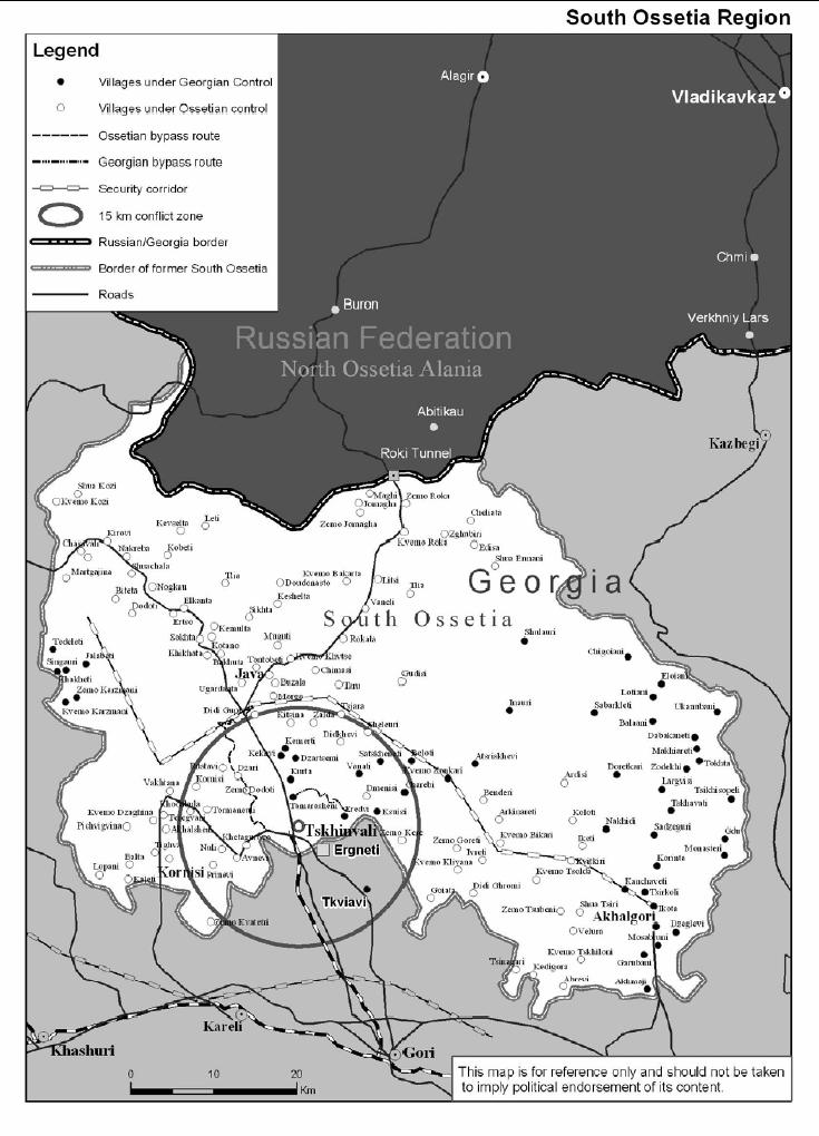
| Opis | South Ossetia detailed map |
| Datum | november 2004 [1] |
| Izvor | International Crisis Group: South Ossetia Region (PDF), part of Georgia: Avoiding War in South Ossetia (PDF) |
| Autor | International Crisis Group |
| Dopuštenje (Naknadno korištenje ove datoteke) |
PD ("Unless otherwise specifically stated, no claim to copyright is being asserted by Crisis Group and material on this website may be freely used as in the public domain.") |
| Ostale verzije | en:Image:SouthOssetia region detailed map.JPG |
| Ovaj rad je objavljen u javno vlasništvo od strane autora International Crisis Group. Ovo se primjenjuje širom svijeta. U nekim državama ovo zakonski nije moguće; u tom slučaju: International Crisis Group dopušta svima pravo korištenja ovog rada u bilo koju svrhu, bez ikakvih uslova, osim ako su takvi uslovi zakonski neophodni.
|
Historija datoteke
Kliknite na datum/vrijeme da vidite verziju datoteke iz tog vremena.
| Datum/vrijeme | Smanjeni pregled | Dimenzije | Korisnik | Komentar | |
|---|---|---|---|---|---|
| trenutno | 13:19, 13 novembar 2006 | | 735 × 1.020 (115 KB) | Hardscarf | {{Information |Description=South Ossetia detailed map |Source=International Crisis Group: [http://www.internal-displacement.org/8025708F004BE3B1/(httpInfoFiles)/D857161E0D1400E08025709F0041D8AD/$file/South%20Ossetia%20ICG.pdf South Ossetia Region] (PD |
Upotreba datoteke
Sljedeća stranica koristi ovu datoteku:
Globalna upotreba datoteke
Sljedeći wikiji koriste ovu datoteku:
- Upotreba na ar.wikipedia.org
- Upotreba na azb.wikipedia.org
- Upotreba na bg.wikipedia.org
- Upotreba na ca.wikipedia.org
- Upotreba na cs.wikipedia.org
- Upotreba na cs.wikinews.org
- Upotreba na de.wikipedia.org
- Upotreba na en.wikipedia.org
- Upotreba na es.wikipedia.org
- Upotreba na fa.wikipedia.org
- Upotreba na fi.wikipedia.org
- Upotreba na fr.wikipedia.org
- Upotreba na fr.wikinews.org
- Upotreba na he.wikipedia.org
- Upotreba na hr.wikipedia.org
- Upotreba na it.wikipedia.org
- Upotreba na ja.wikipedia.org
- Upotreba na ka.wikipedia.org
- Upotreba na ko.wikipedia.org
- Upotreba na mk.wikipedia.org
- Upotreba na nl.wikipedia.org
- Upotreba na no.wikipedia.org
- Upotreba na pt.wikipedia.org
- Upotreba na ru.wikipedia.org
- Upotreba na sh.wikipedia.org
- Upotreba na sq.wikipedia.org
- Upotreba na sr.wikipedia.org
- Upotreba na sv.wikipedia.org
- Upotreba na uk.wikipedia.org
Pogledajte globalne upotrebe ove datoteke.