
Datoteka:Map of Versailles in 1789 by William R Shepherd (died 1934).jpg
Veličina ovog prikaza: 800 × 587 piksela. Ostale rezolucije: 320 × 235 piksela | 640 × 470 piksela | 1.024 × 752 piksela | 1.280 × 940 piksela | 1.572 × 1.154 piksela.
Izvorna datoteka (1.572 × 1.154 piksela, veličina datoteke: 864 KB, MIME tip: image/jpeg)
| Ova datoteka je s Wikimedia Commonsa. Opis s njene stranice opisa datoteke prikazan je ispod. Commons je skladište slobodnih medija i datoteka za sve projekte fondacije Wikimedia. Možete i Vi pomoći. |
.jpg)
Sažetak
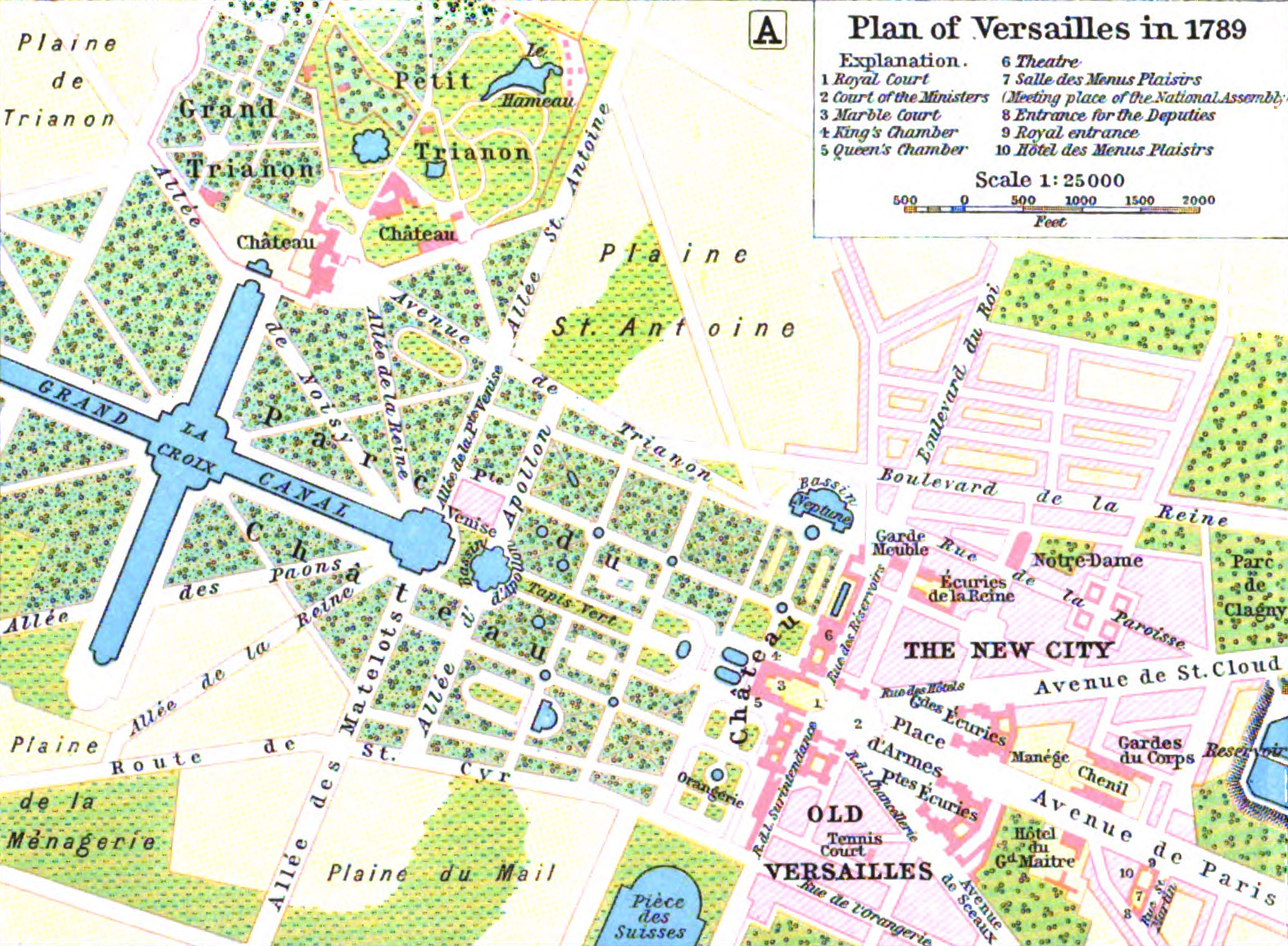
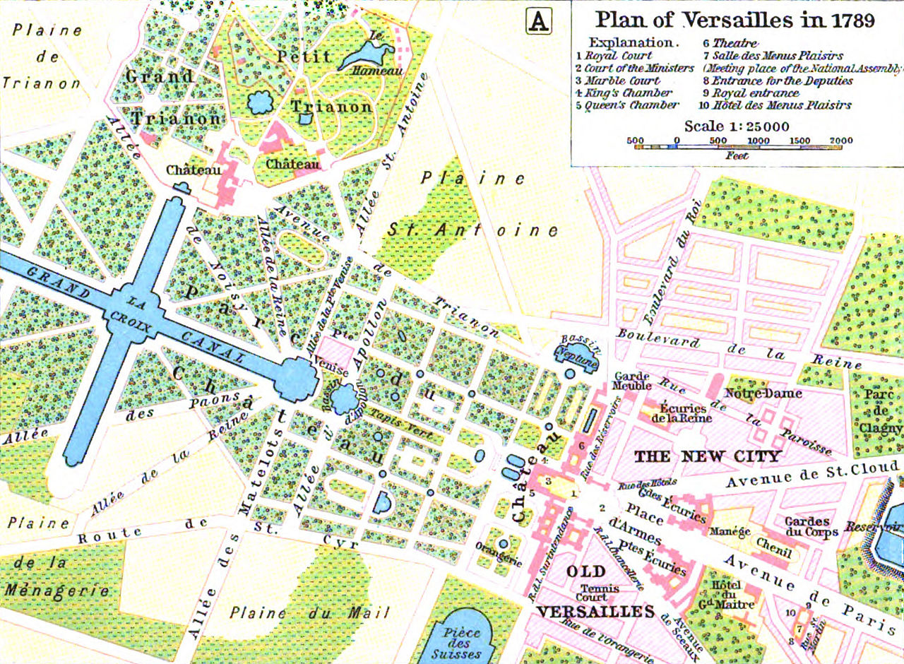
| William Robert Shepherd: Plan of Versailles in 1789
( |
|||||||||||||||||||||||
|---|---|---|---|---|---|---|---|---|---|---|---|---|---|---|---|---|---|---|---|---|---|---|---|
| Artist |
|
||||||||||||||||||||||
| Title |
Plan of Versailles in 1789 |
||||||||||||||||||||||
| Datum | 1911 | ||||||||||||||||||||||
| Dimensions | visina: 13,3 cm; širina: 19,8 cm | ||||||||||||||||||||||
| Notes |
|
||||||||||||||||||||||
| Source/Photographer |
|
||||||||||||||||||||||
.jpg)
Licenciranje
|
This is a faithful photographic reproduction of a two-dimensional, public domain work of art. The work of art itself is in the public domain for the following reason:
The official position taken by the Wikimedia Foundation is that "faithful reproductions of two-dimensional public domain works of art are public domain".
This photographic reproduction is therefore also considered to be in the public domain in the United States. In other jurisdictions, re-use of this content may be restricted; see Reuse of PD-Art photographs for details. | ||||
Historija datoteke
Kliknite na datum/vrijeme da vidite verziju datoteke iz tog vremena.
| Datum/vrijeme | Smanjeni pregled | Dimenzije | Korisnik | Komentar | |
|---|---|---|---|---|---|
| trenutno | 11:14, 5 august 2015 | | 1.572 × 1.154 (864 KB) | Robert.Allen | from the HathiTrust copy of the book, better color, somewhat higher resolution |
| 02:39, 5 juli 2005 |  | 771 × 579 (174 KB) | Kocio | A map of Versailles in 1789 from William R Shepherd's ''Historical Atlas''. (from: http://en.wikipedia.org/wiki/Map_of_Versailles_in_1789_by_William_R_Shepherd_(died_1934).jpg) {{PD}} |
Upotreba datoteke
Sljedeća stranica koristi ovu datoteku:
Globalna upotreba datoteke
Sljedeći wikiji koriste ovu datoteku:
- Upotreba na ast.wikipedia.org
- Upotreba na azb.wikipedia.org
- Upotreba na az.wikipedia.org
- Upotreba na bg.wikipedia.org
- Upotreba na cs.wikipedia.org
- Upotreba na en.wikipedia.org
- Upotreba na es.wikipedia.org
- Upotreba na fi.wikipedia.org
- Upotreba na fr.wikipedia.org
- Upotreba na he.wikipedia.org
- Upotreba na hr.wikipedia.org
- Upotreba na hu.wikipedia.org
- Upotreba na it.wikipedia.org
- Upotreba na ja.wikipedia.org
- Upotreba na lb.wikipedia.org
- Upotreba na lt.wikipedia.org
- Upotreba na mk.wikipedia.org
- Upotreba na nl.wikipedia.org
- Upotreba na pl.wikipedia.org
- Upotreba na pt.wikipedia.org
- Upotreba na sh.wikipedia.org
- Upotreba na simple.wikipedia.org
- Upotreba na sr.wikipedia.org
- Upotreba na tr.wikipedia.org
- Upotreba na vi.wikipedia.org
- Upotreba na zh.wikipedia.org
.jpg)