
Datoteka:Nazi-Soviet 1941.png
Nazi-Soviet_1941.png (372 × 460 piksela, veličina datoteke: 78 KB, MIME tip: image/png)
| Ova datoteka je s Wikimedia Commonsa. Opis s njene stranice opisa datoteke prikazan je ispod. Commons je skladište slobodnih medija i datoteka za sve projekte fondacije Wikimedia. Možete i Vi pomoći. |

|
This military map image could be re-created using vector graphics as an SVG file. This has several advantages; see Commons:Media for cleanup for more information. If an SVG form of this image is available, please upload it and afterwards replace this template with
{{vector version available|new image name}}.
It is recommended to name the SVG file “Nazi-Soviet 1941.svg”—then the template Vector version available (or Vva) does not need the new image name parameter. |
Sažetak
| Opis |
English: From the original en.wikipedia page:
|
| Datum | 9 mart 2009 (original upload date) |
| Izvor | Transferred from en.wikipedia to Commons by Trần Nguyễn Minh Huy. |
| Autor | The original uploader was Mosedschurte at engleski Wikipedia. |
| Ostale verzije | Second World War Europe 05 1941 east fr.svg |
Licenciranje

|
Dozvoljeno je kopirati, distribuirati i/ili mijenjati ovaj članak pod uslovima navedenim u GNU licenci za slobodnu dokumentaciju, verzija 1.2 ili kasnijom verzijom izdatom od Free Software Foundation; bez nepromjenljivih dijelova, te bez sadržaja na naslovnoj i zadnjoj strani. Kopija licence se nalazi pod poglavljem GNU Free Documentation License. |
| Ova datoteka je licencirana pod Creative Commons Attribution-Share Alike 3.0 neportiranom licencom. | ||
| ||
| Ova oznaka licence je dodana na ovu datoteku kao dio GFDL ažuriranja licence. |

|
Legal disclaimer This image contains a symbol prohibited by law in some nations, owing to it being a representation of communism, socialism, or a similar governmental structure; or of an associated political party/organization:
Imagery covered may include the hammer and sickleen, red star, emblems/insignias, flags or images of leaders. |

|
Legal disclaimer This image shows (or resembles) a symbol that was used by the National Socialist (NSDAP/Nazi) government of Germany or an organization closely associated to it, or another party which has been banned by the Federal Constitutional Court of Germany. The use of insignia of organizations that have been banned in Germany (like the Nazi swastika or the arrow cross) may also be illegal in Austria, Hungary, Poland, Czech Republic, France, Brazil, Israel, Ukraine, Russia and other countries, depending on context. In Germany, the applicable law is paragraph 86a of the criminal code (StGB), in Poland – Art. 256 of the criminal code (Dz.U. 1997 nr 88 poz. 553). |
Originalni zapisnik postavljanja
- 2009-03-09 17:05 Mosedschurte 372×460× (79594 bytes) ===English=== * Description: Second world war map on June 1941 * Source: Own map, based on the maps of the [http://www.lib.utexas.edu/maps/ University of Texas Libraries] * Author: [[User:Mosedschurte|Mosedschurte]], February 12, 2009 ===License=== {{GFD
- 2009-02-18 18:26 Mosedschurte 385×479× (64782 bytes) ===English=== * Description: Second world war map on June 1941 * Source: Own map, based on the maps of the [http://www.lib.utexas.edu/maps/ University of Texas Libraries] * Author: [[User:Mosedschurte|Mosedschurte]], February 12, 2009 ===License=== {{GFD
- 2009-02-18 07:13 Mosedschurte 377×447× (62398 bytes) ===English=== * Description: Second world war map on June 1941 * Source: Own map, based on the maps of the [http://www.lib.utexas.edu/maps/ University of Texas Libraries] * Author: [[User:Mosedschurte|Mosedschurte]], February 12, 2009 ===License=== {{GFD
- 2009-02-12 12:54 Mosedschurte 398×468× (64310 bytes) ===English=== * Description: Second world war map on June 1941 * Source: Own map, based on the maps of the [http://www.lib.utexas.edu/maps/ University of Texas Libraries] * Author: [[User:Mosedschurte|Mosedschurte]], February 12, 2009 ===License=== {{GFD
- 2009-02-12 12:50 Mosedschurte 383×463× (63199 bytes) ===English=== * Description: Second world war map on June 1941 * Source: Own map, based on the maps of the [http://www.lib.utexas.edu/maps/ University of Texas Libraries] * Author: [[User:Mosedschurte|Mosedschurte]], February 12, 2009 ===License=== {{GFD
Historija datoteke
Kliknite na datum/vrijeme da vidite verziju datoteke iz tog vremena.
| Datum/vrijeme | Smanjeni pregled | Dimenzije | Korisnik | Komentar | |
|---|---|---|---|---|---|
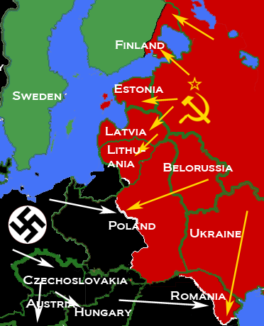
| trenutno | 11:26, 5 april 2010 | | 372 × 460 (78 KB) | Trần Nguyễn Minh Huy | {{Information |Description={{en|* Description: Map depicting most of Central and Eastern Europe, showing 1938 borders, along with Axis (black) and Soviet (red) military and political advances until late 1940. * Source: Own map, based on the maps of the [h |
Upotreba datoteke
Sljedeća stranica koristi ovu datoteku:
Globalna upotreba datoteke
Sljedeći wikiji koriste ovu datoteku:
- Upotreba na ar.wikipedia.org
- Upotreba na bn.wikipedia.org
- Upotreba na de.wikipedia.org
- Upotreba na el.wikipedia.org
- Upotreba na en.wikipedia.org
- Upotreba na es.wikipedia.org
- Upotreba na fr.wikipedia.org
- Upotreba na hr.wikipedia.org
- Upotreba na id.wikipedia.org
- Upotreba na lv.wikipedia.org
- Upotreba na pl.wikipedia.org
- Upotreba na pt.wikipedia.org
- Upotreba na ro.wikipedia.org
- Upotreba na sr.wikipedia.org
- Upotreba na tl.wikipedia.org
- Upotreba na uk.wikipedia.org
- Upotreba na vi.wikipedia.org
- Upotreba na www.wikidata.org
- Upotreba na zh.wikipedia.org