
Datoteka:2019-11-26 Mamurras, Albania M6.4 earthquake shakemap (USGS).jpg
Veličina ovog prikaza: 471 × 600 piksela. Ostale rezolucije: 188 × 240 piksela | 377 × 480 piksela | 786 × 1.001 piksela.
Izvorna datoteka (786 × 1.001 piksela, veličina datoteke: 388 KB, MIME tip: image/jpeg)
| Ova datoteka je s Wikimedia Commonsa. Opis s njene stranice opisa datoteke prikazan je ispod. Commons je skladište slobodnih medija i datoteka za sve projekte fondacije Wikimedia. Možete i Vi pomoći. |
.jpg)
Sažetak
| Opis | |
| Datum | |
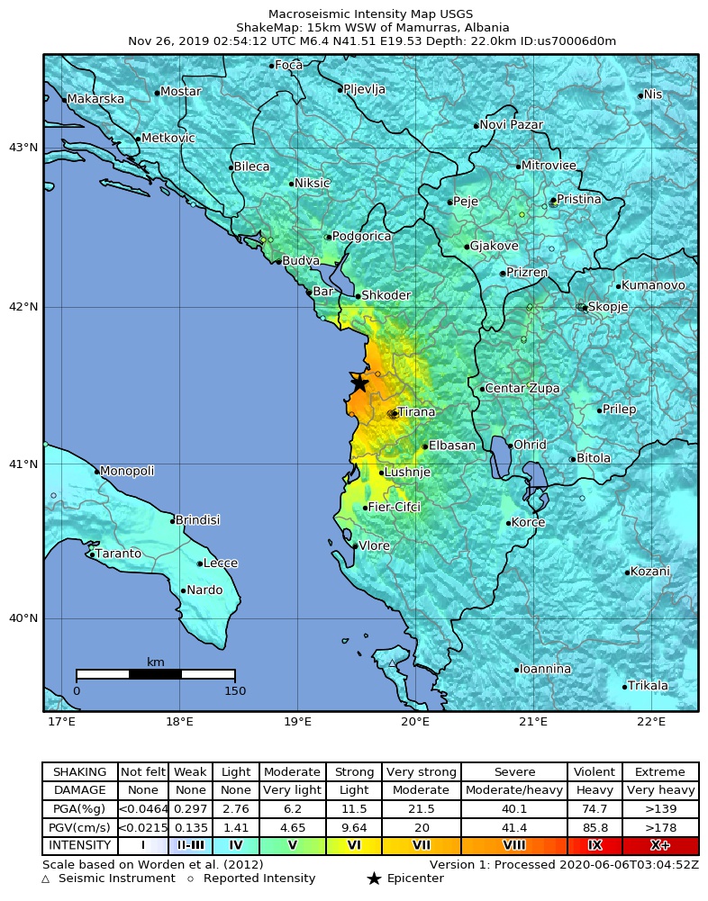
| Izvor | https://earthquake.usgs.gov/earthquakes/eventpage/us70006d0m |
| Autor | United States Geological Survey |
Licenciranje
This image is in the public domain in the United States because it only contains materials that originally came from the United States Geological Survey, an agency of the United States Department of the Interior. For more information, see the official USGS copyright policy.
|
Historija datoteke
Kliknite na datum/vrijeme da vidite verziju datoteke iz tog vremena.
| Datum/vrijeme | Smanjeni pregled | Dimenzije | Korisnik | Komentar | |
|---|---|---|---|---|---|
| trenutno | 13:34, 2 septembar 2020 | | 786 × 1.001 (388 KB) | IllCom | New Version by USGS |
| 02:04, 19 decembar 2019 |  | 799 × 1.027 (384 KB) | Cewbot | Import USGS updated earthquake map, shakemap id: urn:usgs-product:us:shakemap:us70006d0m:1576710484988 (2019-12-18T23:08:04.988Z) | |
| 08:03, 28 novembar 2019 |  | 799 × 1.027 (384 KB) | Cewbot | Import USGS updated earthquake map, shakemap id: urn:usgs-product:us:shakemap:us70006d0m:1574918746692 (2019-11-28T05:25:46.692Z) | |
| 06:03, 27 novembar 2019 |  | 799 × 1.027 (384 KB) | Cewbot | Import USGS updated earthquake map, shakemap id: urn:usgs-product:us:shakemap:us70006d0m:1574823443193 (2019-11-27T02:57:23.193Z) | |
| 08:03, 26 novembar 2019 |  | 799 × 1.027 (384 KB) | Cewbot | Import USGS updated earthquake map, shakemap id: urn:usgs-product:us:shakemap:us70006d0m:1574744239038 (2019-11-26T04:57:19.038Z) | |
| 06:05, 26 novembar 2019 |  | 799 × 1.027 (384 KB) | Cewbot | Import USGS earthquake map, shakemap id: urn:usgs-product:us:shakemap:us70006d0m:1574739829558 (2019-11-26T03:43:49.558Z) |
Upotreba datoteke
Nema stranica koje koriste ovu datoteku.
Globalna upotreba datoteke
Sljedeći wikiji koriste ovu datoteku:
- Upotreba na az.wikipedia.org
- Upotreba na bg.wikipedia.org
- Upotreba na de.wikipedia.org
- Upotreba na el.wikipedia.org
- Upotreba na en.wikipedia.org
- Upotreba na es.wikipedia.org
- Upotreba na fr.wikipedia.org
- Upotreba na he.wikipedia.org
- Upotreba na hr.wikipedia.org
- Upotreba na hu.wikipedia.org
- Upotreba na id.wikipedia.org
- Upotreba na it.wikipedia.org
- Upotreba na ja.wikipedia.org
- Upotreba na mr.wikipedia.org
- Upotreba na pl.wikipedia.org
- Upotreba na pt.wikipedia.org
- Upotreba na ro.wikipedia.org
- Upotreba na ru.wikipedia.org
- Upotreba na sq.wikipedia.org
- Upotreba na te.wikipedia.org
- Upotreba na tr.wikipedia.org
- Upotreba na www.wikidata.org
- Upotreba na zh.wikipedia.org
.jpg)