
Datoteka:25th meridian Libya.png
Veća rezolucija nije dostupna.
25th_meridian_Libya.png (330 × 354 piksela, veličina datoteke: 25 KB, MIME tip: image/png)
| Ova datoteka je s Wikimedia Commonsa. Opis s njene stranice opisa datoteke prikazan je ispod. Commons je skladište slobodnih medija i datoteka za sve projekte fondacije Wikimedia. Možete i Vi pomoći. |
Sažetak
| Opis |
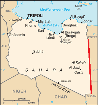
English: Map of Libya, showing the 25th meridian east as part of the border with Egypt and Sudan |
| Datum | |
| Izvor | Based on map of Libya from CIA World Factbook |
| Autor | Bazonka; CIA |
Licenciranje
This work is in the public domain in the United States because it is a work prepared by an officer or employee of the United States Government as part of that person’s official duties under the terms of Title 17, Chapter 1, Section 105 of the US Code.
Note: This only applies to original works of the Federal Government and not to the work of any individual U.S. state, territory, commonwealth, county, municipality, or any other subdivision. This template also does not apply to postage stamp designs published by the United States Postal Service since 1978. (See § 313.6(C)(1) of Compendium of U.S. Copyright Office Practices). It also does not apply to certain US coins; see The US Mint Terms of Use.
|
 | |
| Ova datoteka je identificirana kao slobodna od poznatih ograničenja po zakonu o autorskim pravima, uključujući sva povezana i srodna prava. | ||
Historija datoteke
Kliknite na datum/vrijeme da vidite verziju datoteke iz tog vremena.
| Datum/vrijeme | Smanjeni pregled | Dimenzije | Korisnik | Komentar | |
|---|---|---|---|---|---|
| trenutno | 20:38, 3 oktobar 2012 | | 330 × 354 (25 KB) | Bazonka | User created page with UploadWizard |
Upotreba datoteke
Sljedeća stranica koristi ovu datoteku:
Globalna upotreba datoteke
Sljedeći wikiji koriste ovu datoteku:
- Upotreba na ca.wikipedia.org
- Upotreba na el.wikipedia.org
- Upotreba na en.wikipedia.org
- Upotreba na es.wikipedia.org
- Upotreba na fa.wikipedia.org
- Upotreba na fr.wikipedia.org
- Upotreba na ilo.wikipedia.org
- Upotreba na ja.wikipedia.org
- Upotreba na ko.wikipedia.org
- Upotreba na mk.wikipedia.org
- Upotreba na pt.wikipedia.org
- Upotreba na th.wikipedia.org
- Upotreba na zh.wikipedia.org