
Datoteka:Australia Victoria location map highways.svg

Veličina ovog PNG pregleda za ovu SVG datoteku: 800 × 563 piksela. Ostale rezolucije: 320 × 225 piksela | 640 × 450 piksela | 1.024 × 720 piksela | 1.280 × 900 piksela | 2.560 × 1.800 piksela | 1.375 × 967 piksela.
Izvorna datoteka (SVG datoteka, nominalno 1.375 × 967 piksela, veličina datoteke: 729 KB)
| Ova datoteka je s Wikimedia Commonsa. Opis s njene stranice opisa datoteke prikazan je ispod. Commons je skladište slobodnih medija i datoteka za sve projekte fondacije Wikimedia. Možete i Vi pomoći. |
| Opis |
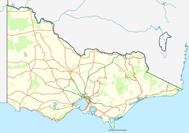
English: Location map with highways (in Orange) and freeways (in Green) of Victoria, Australia. Also shows state forests and national parks.
Equirectangular projection, N/S stretching 124 %. Geographic limits of the map:
Deutsch: Positionskarte mit Highways (Straße zwischen Großstädte; in Orange) and Freeways (~Autobahnen; in Grün) von Victoria, Australien. Auch mit Nationalparks
Quadratische Plattkarte, N-S-Streckung 124 %. Geographische Begrenzung der Karte:
|
| Datum | (UTC) |
| Izvor | |
| Autor |
|
| This is a retouched picture, which means that it has been digitally altered from its original version. Modifications: show roads and national parks. The original can be viewed here: Australia Victoria location map blank.svg:
|
Ja, vlasnik autorskog prava ovog djela, ovdje ga objavljujem pod sljedećom licencom:
Ova datoteka je licencirana pod Creative Commons Attribution-Share Alike 3.0 neportiranom licencom.
- Slobodni ste:
- da dijelite – da kopirate, distributirate i prenosite djelo
- da remiksate – da prilagodite djelo
- Pod sljedećim uslovima:
- pripisivanje – Morate pripisati odgovarajuće autorske zasluge, osigurati link ka licenci i naznačiti jesu li napravljene izmjene. To možete uraditi na bilo koji razumni način, ali ne tako da se sugerira da davalac licence odobrava Vas ili Vašu upotrebu njegovog djela.
- dijeli pod istim uslovima – Ako mijenjate, transformišete ili nadograđujete ovaj materijal, morate ga objaviti i distribuirati samo pod istom ili sličnom licencom poput ove.
Originalni zapisnik postavljanja
This image is a derivative work of the following images:
- File:Australia_Victoria_location_map_blank.svg licensed with Cc-by-sa-3.0
- 2010-04-10T01:20:08Z Roke 1375x967 (279504 Bytes) {{Information |Description={{de|Positionskarte von [[:de:Victoria (Australien)|Victoria]], [[:de:Australien|Australien]]}} Quadratische Plattkarte, N-S-Streckung 124 %. Geographische Begrenzung der Karte: * N: 33.8° S * S: 3
Uploaded with derivativeFX
Historija datoteke
Kliknite na datum/vrijeme da vidite verziju datoteke iz tog vremena.
| Datum/vrijeme | Smanjeni pregled | Dimenzije | Korisnik | Komentar | |
|---|---|---|---|---|---|
| trenutno | 15:58, 25 februar 2011 | | 1.375 × 967 (729 KB) | Cassowary | {{Information |Description={{en|Location map with highways (in Orange) and freeways (in Green) of Victoria, Australia. Also shows state forests and national parks.}} Equirectangular projection, N/S stretchi |
Upotreba datoteke
Sljedeće 3 stranice koriste ovu datoteku:
Globalna upotreba datoteke
Sljedeći wikiji koriste ovu datoteku:
- Upotreba na ceb.wikipedia.org
- Upotreba na en.wikipedia.org
- Upotreba na es.wikipedia.org
- Upotreba na fa.wikipedia.org
- Upotreba na kn.wikipedia.org
- Upotreba na pl.wikipedia.org
- Upotreba na pl.wikibooks.org
- Upotreba na shn.wikipedia.org
- Upotreba na simple.wikipedia.org
- Upotreba na si.wikipedia.org
- Upotreba na sl.wikipedia.org
- Upotreba na tr.wikipedia.org
- Upotreba na uz.wikipedia.org
- Upotreba na war.wikipedia.org