
Datoteka:Australian external territories.png
Veća rezolucija nije dostupna.
Australian_external_territories.png (644 × 376 piksela, veličina datoteke: 14 KB, MIME tip: image/png)
| Ova datoteka je s Wikimedia Commonsa. Opis s njene stranice opisa datoteke prikazan je ispod. Commons je skladište slobodnih medija i datoteka za sve projekte fondacije Wikimedia. Možete i Vi pomoći. |

|
This locator map image could be re-created using vector graphics as an SVG file. This has several advantages; see Commons:Media for cleanup for more information. If an SVG form of this image is available, please upload it and afterwards replace this template with
{{vector version available|new image name}}.
It is recommended to name the SVG file “Australian external territories.svg”—then the template Vector version available (or Vva) does not need the new image name parameter. |
Sažetak
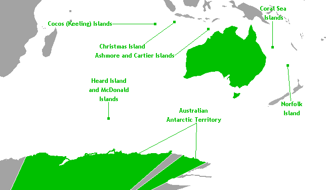
This is a map of Australia's external territories. The base map is Image:Antarctica territorial claims.png by User:Astrokey44 since it shows the AAT. The location of the other territories is Image:BlankMap-World-v6.png by the same user. The previous maps are under the GFDL; therefore, this map is too.
Licenciranje
Ja, vlasnik autorskog prava ovog djela, ovdje ga objavljujem pod sljedećim licencama:

|
Dozvoljeno je kopirati, distribuirati i/ili mijenjati ovaj članak pod uslovima navedenim u GNU licenci za slobodnu dokumentaciju, verzija 1.2 ili kasnijom verzijom izdatom od Free Software Foundation; bez nepromjenljivih dijelova, te bez sadržaja na naslovnoj i zadnjoj strani. Kopija licence se nalazi pod poglavljem GNU Free Documentation License. |
| Ova datoteka je licencirana pod Creative Commons Attribution-Share Alike 3.0 neportiranom licencom. | ||
| ||
| Ova oznaka licence je dodana na ovu datoteku kao dio GFDL ažuriranja licence. |
Možete odabrati licencu po vašem izboru.
Historija datoteke
Kliknite na datum/vrijeme da vidite verziju datoteke iz tog vremena.
| Datum/vrijeme | Smanjeni pregled | Dimenzije | Korisnik | Komentar | |
|---|---|---|---|---|---|
| trenutno | 08:40, 18 novembar 2010 | | 644 × 376 (14 KB) | Hoshie | rm boundary lines in Africa, SE Asia, and PNG to focus on Australia and its territories; fixed color of the Comoros |
| 12:00, 17 mart 2007 |  | 644 × 376 (14 KB) | Hoshie | This is a map of Australia's external territories. The base map is Image:Antarctica territorial claims.png by User:Astrokey44 since it shows the AAT. The location of the other territories is Image:BlankMap-World-v6.png by the same user. The |
Upotreba datoteke
Sljedeće 2 stranice koriste ovu datoteku:
Globalna upotreba datoteke
Sljedeći wikiji koriste ovu datoteku:
- Upotreba na af.wikipedia.org
- Upotreba na az.wikipedia.org
- Upotreba na ba.wikipedia.org
- Upotreba na be.wikipedia.org
- Upotreba na br.wikipedia.org
- Upotreba na cs.wikipedia.org
- Upotreba na de.wikipedia.org
- Upotreba na en.wikipedia.org
- Upotreba na eo.wikipedia.org
- Upotreba na gl.wikipedia.org
- Upotreba na hi.wikipedia.org
- Upotreba na hy.wikipedia.org
- Upotreba na incubator.wikimedia.org
- Upotreba na ka.wikipedia.org
- Upotreba na ko.wikipedia.org
- Upotreba na lv.wikipedia.org
- Upotreba na mr.wikipedia.org
- Upotreba na oc.wikipedia.org
- Upotreba na pa.wikipedia.org
- Upotreba na ru.wikipedia.org
- Upotreba na ru.wikinews.org
- Upotreba na sh.wikipedia.org
- Upotreba na simple.wikipedia.org
- Upotreba na sk.wikipedia.org
- Upotreba na sr.wikipedia.org
- Upotreba na ta.wikipedia.org
- Upotreba na th.wikipedia.org
- Upotreba na tr.wikipedia.org
- Upotreba na vec.wikipedia.org
- Upotreba na war.wikipedia.org
- Upotreba na xmf.wikipedia.org
- Upotreba na zh.wikipedia.org