
Datoteka:Bödele Bregenzerwald Panorama.jpg
Veličina ovog prikaza: 800 × 231 piksela. Ostale rezolucije: 320 × 92 piksela | 640 × 185 piksela | 1.024 × 296 piksela | 1.280 × 370 piksela | 6.956 × 2.010 piksela.
Izvorna datoteka (6.956 × 2.010 piksela, veličina datoteke: 2,4 MB, MIME tip: image/jpeg)
| Ova datoteka je s Wikimedia Commonsa. Opis s njene stranice opisa datoteke prikazan je ispod. Commons je skladište slobodnih medija i datoteka za sve projekte fondacije Wikimedia. Možete i Vi pomoći. |
|
| Opis |
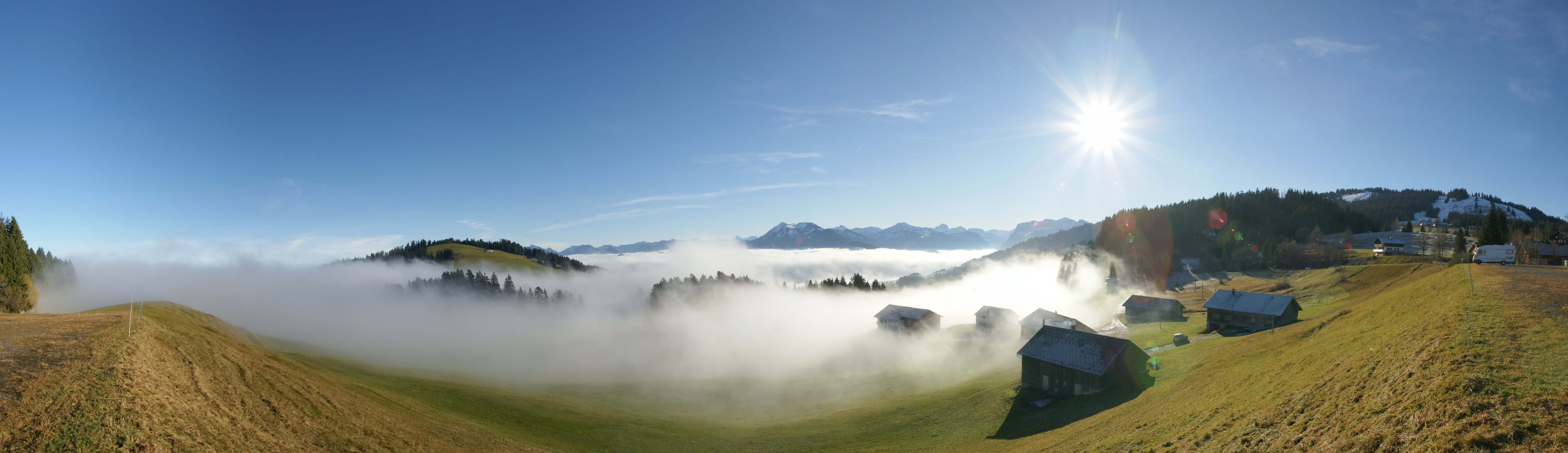
Deutsch: 180° Panorama am Bödele, gelegen zwischen Dornbirn und Schwarzenberg, Vorarlberg, Österreich. Die 2 Bergspitzen in der Bildmitte sind die Winterstaude 1877m und rechts der Hohe Ifen 2230m. Das Bergmassiv unter der Sonne ist die Nordflanke der Kanisfluh. Am rechten Bildrand zu sehen das Skigebiet Bödele mit dem Hochälpelekopf 1464m.
English: 180 ° panorama at Bödele, located between Dornbirn and Schwarzenberg, Vorarlberg, Austria. The 2 peaks in the middle are the winter Perennial 1877m and the right of the High Ifen 2230m. The mountain range under the sun is the northern flank of Kanisfluh. On the right screen to see the ski area with the Bödele Hochälpelekopf 1464m.
Français : Vue panoramique à 180 ° depuis Bödele, un village entre Dornbirn et Schwarzenberg, dans le Vorarlberg, en Autriche. Les deux sommets visibles à l'horizon au centre sont le Winterstaude (1877) et le Hoher Ifen (2230). La chaine de montagne juste sous le soleil correspond au flanc nord du Kanisfluh. Tout à droite de la photo on voit le domaine skiable culminant au Bödele Hochälpelekopf à 1464m.
|
||
| Datum | |||
| Izvor | Vlastito djelo | ||
| Autor | böhringer friedrich | ||
| Dopuštenje (Naknadno korištenje ove datoteke) |
Ja, vlasnik autorskog prava ovog djela, ovdje ga objavljujem pod sljedećom licencom: Ova datoteka je licencirana pod Creative Commons Attribution-Share Alike 2.5 generičkom licencom.
|
||
| Ostale verzije |
|

This Photo was taken by Böhringer Friedrich.
|
Feel free to use my photos, but please mention me as the author and if you want send me a message. or (rufre@lenz-nenning.at) |
| Camera location | | View this and other nearby images on: OpenStreetMap |
|---|
| Annotations | This image is annotated: View the annotations at Commons |
Historija datoteke
Kliknite na datum/vrijeme da vidite verziju datoteke iz tog vremena.
| Datum/vrijeme | Smanjeni pregled | Dimenzije | Korisnik | Komentar | |
|---|---|---|---|---|---|
| trenutno | 21:32, 21 novembar 2008 | 6.956 × 2.010 (2,4 MB) | Böhringer | {{Information |Description= {{de| 180° Panorama am Bödele, gelegen zwischen Dornbirn und Schwarzenberg. Die 2 Bergspitzen in der Bildmitte sind die [[:de:Winterstaude|Winterstaude 1877m | |
| 12:34, 17 novembar 2008 | 6.956 × 2.010 (8,29 MB) | Böhringer | {{Information |Description= {{de| 180° Panorama am Bödele, gelegen zwischen Dornbirn und Schwarzenberg.}} |Source= own work |Date= 2008-11-16 |Author= [[User:Böhringer|böhringer fried |
Upotreba datoteke
Sljedeća stranica koristi ovu datoteku:
Globalna upotreba datoteke
Sljedeći wikiji koriste ovu datoteku:
- Upotreba na de.wikipedia.org
- Upotreba na en.wikipedia.org
- Upotreba na es.wikipedia.org
- Upotreba na es.wikivoyage.org
- Upotreba na et.wikipedia.org
- Upotreba na fr.wikipedia.org
- Upotreba na hy.wikipedia.org
- Upotreba na mk.wikipedia.org
- Upotreba na nl.wikipedia.org
- Upotreba na pl.wikipedia.org
- Upotreba na sq.wikipedia.org
- Upotreba na sv.wikipedia.org
- Upotreba na uk.wikipedia.org
- Upotreba na vi.wikipedia.org