
Datoteka:British Columbia-map.png
Veća rezolucija nije dostupna.
British_Columbia-map.png (280 × 230 piksela, veličina datoteke: 14 KB, MIME tip: image/png)
| Ova datoteka je s Wikimedia Commonsa. Opis s njene stranice opisa datoteke prikazan je ispod. Commons je skladište slobodnih medija i datoteka za sve projekte fondacije Wikimedia. Možete i Vi pomoći. |

|
File:British Columbia, Canada.svg is a vector version of this file. It should be used in place of this PNG file when not inferior.
File:British Columbia-map.png → File:British Columbia, Canada.svg
For more information, see Help:SVG. |
 |
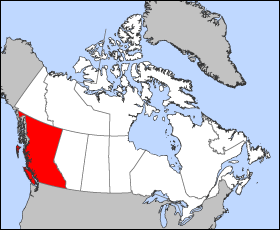
Map of British Columbia
Projection: Lambert azimuthal equal-area
Geospatial data from: The Atlas of Canada, The National Atlas of the United States archive copy at the Wayback Machine and U.S. Geological Survey
Cartographer: John Fowler
| Ja, vlasnik autorskog prava ovog djela, objavljujem ovaj rad u javno vlasništvo. Ovo se primjenjuje u cijelom svijetu. U nekim državama ovo zakonski nije moguće; u tom slučaju: Ja dopuštam svima pravo korištenja ovog rada u bilo koju svrhu, bez ikakvih uslova, osim ako su takvi uslovi zakonski neophodni. |
Historija datoteke
Kliknite na datum/vrijeme da vidite verziju datoteke iz tog vremena.
| Datum/vrijeme | Smanjeni pregled | Dimenzije | Korisnik | Komentar | |
|---|---|---|---|---|---|
| trenutno | 14:12, 24 mart 2005 | | 280 × 230 (14 KB) | Voyager | Map of British Columbia Projection: Lambert azimuthal equal-area Geospatial data from: [http://atlas.gc.ca/ The Atlas of Canada], [http://www.nationalatlas.gov/ The National Atlas of the United States] and [http://www.usgs.gov U.S. Geological Survey] C |
Upotreba datoteke
Nema stranica koje koriste ovu datoteku.
Globalna upotreba datoteke
Sljedeći wikiji koriste ovu datoteku:
- Upotreba na fr.wikipedia.org
- Upotreba na he.wikivoyage.org