
Datoteka:Cape Verde-CIA WFB Map.png
Veća rezolucija nije dostupna.
Cape_Verde-CIA_WFB_Map.png (330 × 355 piksela, veličina datoteke: 8 KB, MIME tip: image/png)
| Ova datoteka je s Wikimedia Commonsa. Opis s njene stranice opisa datoteke prikazan je ispod. Commons je skladište slobodnih medija i datoteka za sve projekte fondacije Wikimedia. Možete i Vi pomoći. |
| Opis |
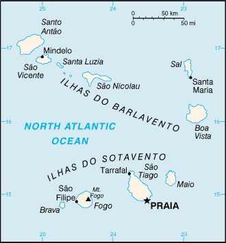
English: A map of the Republic of Cabo Verde, showing major cities. |
|||
| Datum | published 2004 | |||
| Izvor | CIA, The World Factbook, 2004. | |||
| Autor | CIA | |||
| Dopuštenje (Naknadno korištenje ove datoteke) |
|

Historija datoteke
Kliknite na datum/vrijeme da vidite verziju datoteke iz tog vremena.
| Datum/vrijeme | Smanjeni pregled | Dimenzije | Korisnik | Komentar | |
|---|---|---|---|---|---|
| trenutno | 11:12, 27 mart 2005 | | 330 × 355 (8 KB) | Wolfman~commonswiki | {{CIA-map}} |
Upotreba datoteke
Sljedeća stranica koristi ovu datoteku:
Globalna upotreba datoteke
Sljedeći wikiji koriste ovu datoteku:
- Upotreba na bh.wikipedia.org
- Upotreba na ca.wikipedia.org
- Santiago (Cap Verd)
- Illa de Sal
- Rabo de Junco
- Llista d'illes de Cap Verd
- Illa de Santo Antão
- Plantilla:Illes Cap Verd
- Illes de Barlavento
- Illes de Sotavento
- Illa de São Vicente
- Illa de Santa Luzia
- Ilhéu Branco
- Ilhéu Raso
- Illa de São Nicolau
- Illa de Boa Vista
- Ilhéu dos Pássaros
- Illa Brava
- Illa de Fogo
- Illa de Maio
- Ilhéu do Baluarte
- Ilhéu Laje Branca
- Ilhéu de Sal Rei
- Ilhéu de Santa Maria
- Ilhéus Secos
- Ilhéu Grande
- Ilhéu de Cima
- Mòdul:Location map/data/Cap Verd
- Mòdul:Location map/data/Cap Verd/ús
- Upotreba na de.wikipedia.org
- Upotreba na en.wikipedia.org
- Upotreba na en.wikisource.org
- Upotreba na fa.wikipedia.org
- Upotreba na hi.wikipedia.org
- Upotreba na id.wikipedia.org
- Upotreba na ilo.wikipedia.org
- Upotreba na ja.wikipedia.org
- Upotreba na kn.wikipedia.org
- Upotreba na lt.wiktionary.org
- Upotreba na ml.wikipedia.org
Pogledajte globalne upotrebe ove datoteke.