
Datoteka:Catalpa bignonioides range map 2.png

Veličina ovog prikaza: 600 × 600 piksela. Ostale rezolucije: 240 × 240 piksela | 480 × 480 piksela | 768 × 768 piksela | 1.024 × 1.024 piksela | 2.048 × 2.048 piksela | 2.677 × 2.677 piksela.
Izvorna datoteka (2.677 × 2.677 piksela, veličina datoteke: 89 KB, MIME tip: image/png)
| Ova datoteka je s Wikimedia Commonsa. Opis s njene stranice opisa datoteke prikazan je ispod. Commons je skladište slobodnih medija i datoteka za sve projekte fondacije Wikimedia. Možete i Vi pomoći. |
Sažetak
| Opis |
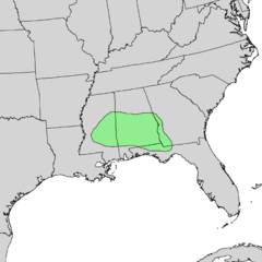
English: Natural distribution map for Catalpa bignonioides |
| Datum | |
| Izvor | USGS Geosciences and Environmental Change Science Center: Digital Representations of Tree Species Range Maps from "Atlas of United States Trees" by Elbert L. Little, Jr. (and other publications) |
| Autor | Elbert L. Little, Jr., of the U.S. Department of Agriculture, Forest Service, and others |
Licenciranje
This work is in the public domain in the United States because it is a work prepared by an officer or employee of the United States Government as part of that person’s official duties under the terms of Title 17, Chapter 1, Section 105 of the US Code.
Note: This only applies to original works of the Federal Government and not to the work of any individual U.S. state, territory, commonwealth, county, municipality, or any other subdivision. This template also does not apply to postage stamp designs published by the United States Postal Service since 1978. (See § 313.6(C)(1) of Compendium of U.S. Copyright Office Practices). It also does not apply to certain US coins; see The US Mint Terms of Use.
|
 | |
| Ova datoteka je identificirana kao slobodna od poznatih ograničenja po zakonu o autorskim pravima, uključujući sva povezana i srodna prava. | ||
Historija datoteke
Kliknite na datum/vrijeme da vidite verziju datoteke iz tog vremena.
| Datum/vrijeme | Smanjeni pregled | Dimenzije | Korisnik | Komentar | |
|---|---|---|---|---|---|
| trenutno | 06:25, 21 novembar 2013 | | 2.677 × 2.677 (89 KB) | Nonenmac | User created page with UploadWizard |
Upotreba datoteke
Sljedeća stranica koristi ovu datoteku:
Globalna upotreba datoteke
Sljedeći wikiji koriste ovu datoteku:
- Upotreba na ar.wikipedia.org
- Upotreba na arz.wikipedia.org
- Upotreba na ast.wikipedia.org
- Upotreba na bg.wikipedia.org
- Upotreba na ca.wikipedia.org
- Upotreba na ceb.wikipedia.org
- Upotreba na cs.wikipedia.org
- Upotreba na en.wikipedia.org
- Upotreba na eo.wikipedia.org
- Upotreba na es.wikipedia.org
- Upotreba na eu.wikipedia.org
- Upotreba na fa.wikipedia.org
- Upotreba na gl.wikipedia.org
- Upotreba na hu.wikipedia.org
- Upotreba na hy.wikipedia.org
- Upotreba na no.wikipedia.org
- Upotreba na pl.wikipedia.org
- Upotreba na ru.wikipedia.org
- Upotreba na sk.wikipedia.org
- Upotreba na sl.wikipedia.org
- Upotreba na sr.wikipedia.org
- Upotreba na sv.wikipedia.org
- Upotreba na uk.wikipedia.org
- Upotreba na www.wikidata.org