
Datoteka:Colonisation 1914.png

Izvorna datoteka (1.425 × 625 piksela, veličina datoteke: 51 KB, MIME tip: image/png)
| Ova datoteka je s Wikimedia Commonsa. Opis s njene stranice opisa datoteke prikazan je ispod. Commons je skladište slobodnih medija i datoteka za sve projekte fondacije Wikimedia. Možete i Vi pomoći. |

Sažetak
| Opis |
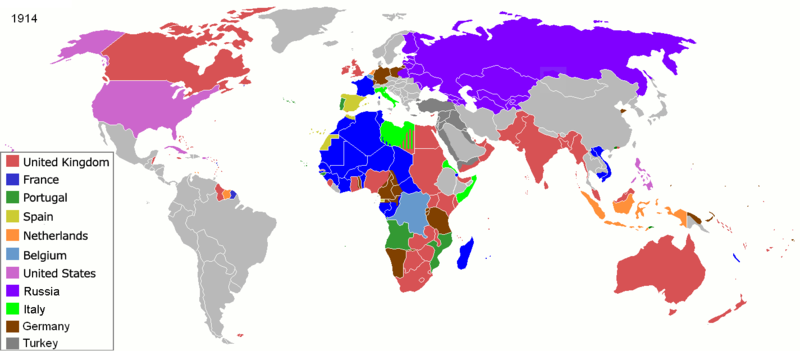
Map of major world powers by year, derived from public domain animated map on wikipedia.
As the orriginal licence of the animation was Public Domain, this image which has been derived from it is too:
|
||||||||||||||||||
| Datum | |||||||||||||||||||
| Izvor | public domain animated map by ArdadN here | ||||||||||||||||||
| Autor | ArdadN | ||||||||||||||||||
.jpg)
._LOC_2001620596.jpg)
Licenciranje

|
This historical map image could be re-created using vector graphics as an SVG file. This has several advantages; see Commons:Media for cleanup for more information. If an SVG form of this image is available, please upload it and afterwards replace this template with
{{vector version available|new image name}}.
It is recommended to name the SVG file “Colonisation 1914.svg”—then the template Vector version available (or Vva) does not need the new image name parameter. |
Historija datoteke
Kliknite na datum/vrijeme da vidite verziju datoteke iz tog vremena.
| Datum/vrijeme | Smanjeni pregled | Dimenzije | Korisnik | Komentar | |
|---|---|---|---|---|---|
| trenutno | 11:07, 8 novembar 2021 | | 1.425 × 625 (51 KB) | Randomastwritter | jubaland |
| 18:32, 15 maj 2020 |  | 1.425 × 625 (51 KB) | Chipmunkdavis | Freeing Belgium and Luxembourg from the Netherlands | |
| 05:05, 3 august 2014 |  | 1.425 × 625 (51 KB) | Alvin Lee | Chinese-Russian boarder | |
| 02:59, 9 septembar 2011 |  | 1.425 × 625 (50 KB) | SpencerCS | Substantial corrections to Ottoman Empire, Africa, and the Pacific | |
| 12:41, 22 mart 2007 |  | 1.425 × 625 (66 KB) | Roke~commonswiki | {{Information |Description=Map of major world powers by year, derived from public domain animated map on wikipedia. {{Maps of world history}} As the orriginal licence of the animation was Public Domain, this image which has been derived from it is too: { |
Upotreba datoteke
Sljedeća stranica koristi ovu datoteku:
Globalna upotreba datoteke
Sljedeći wikiji koriste ovu datoteku:
- Upotreba na ba.wikipedia.org
- Upotreba na ca.wikibooks.org
- Upotreba na cs.wikipedia.org
- Upotreba na de.wikipedia.org
- Upotreba na en.wikipedia.org
- Upotreba na en.wikibooks.org
- Upotreba na es.wikipedia.org
- Upotreba na fa.wikipedia.org
- Upotreba na fr.wikipedia.org
- Upotreba na fr.wikiversity.org
- Upotreba na hu.wikipedia.org
- Upotreba na hy.wikipedia.org
- Upotreba na it.wikipedia.org
- Upotreba na ko.wikipedia.org
- Upotreba na nn.wikipedia.org
- Upotreba na no.wikipedia.org
- Upotreba na oc.wikipedia.org
- Upotreba na ro.wikipedia.org
- Upotreba na ru.wikipedia.org
- Upotreba na sk.wikipedia.org
- Upotreba na uk.wikipedia.org
- Upotreba na zh.wikipedia.org