
Datoteka:Elevation.jpg

Veličina ovog prikaza: 800 × 400 piksela. Ostale rezolucije: 320 × 160 piksela | 640 × 320 piksela | 1.024 × 512 piksela | 1.280 × 640 piksela | 2.560 × 1.280 piksela | 10.800 × 5.400 piksela.
Izvorna datoteka (10.800 × 5.400 piksela, veličina datoteke: 25,61 MB, MIME tip: image/jpeg)
| Ova datoteka je s Wikimedia Commonsa. Opis s njene stranice opisa datoteke prikazan je ispod. Commons je skladište slobodnih medija i datoteka za sve projekte fondacije Wikimedia. Možete i Vi pomoći. |
Sažetak
| Opis |
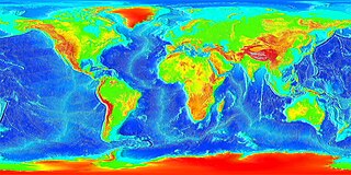
English: Global land and undersea elevation. (flat projection
Deutsch: Globales Höhenprofil (Flachkarte) |
| Datum | Nepoznat datum |
| Izvor | http://www.ngdc.noaa.gov/mgg/image/2minrelief.html |
| Autor | National Oceanic and Atmospheric Administration |
To calculate geografic coordinates to map coordinates: X = (180 + longitude) * width of map / 360 // west is minus Y = (90 + latitude) * height of map / 360 // north is minus
Licenciranje
This image is in the public domain because it contains materials that originally came from the U.S. National Oceanic and Atmospheric Administration, taken or made as part of an employee's official duties.
|
![]()
See also
- Image:LARGE elevation.jpg — a high-resolution (13MB) version of this image
- Image:Earth surface NGDC 2000.jpg — made from similar data
Historija datoteke
Kliknite na datum/vrijeme da vidite verziju datoteke iz tog vremena.
| Datum/vrijeme | Smanjeni pregled | Dimenzije | Korisnik | Komentar | |
|---|---|---|---|---|---|
| trenutno | 22:02, 19 august 2023 | | 10.800 × 5.400 (25,61 MB) | Kersti Nebelsiek | higher resolution |
| 01:11, 14 novembar 2021 |  | 5.400 × 2.700 (14,08 MB) | Antonsusi | resolution | |
| 03:59, 7 mart 2006 |  | 4.320 × 2.160 (1,86 MB) | Interiot~commonswiki | Global land and undersea elevation. Source: http://www.ngdc.noaa.gov/mgg/image/2minrelief.html |
Upotreba datoteke
Sljedeće 2 stranice koriste ovu datoteku:
Globalna upotreba datoteke
Sljedeći wikiji koriste ovu datoteku:
- Upotreba na af.wikipedia.org
- Upotreba na an.wikipedia.org
- Upotreba na ar.wikipedia.org
- Upotreba na ast.wikipedia.org
- Upotreba na awa.wikipedia.org
- Upotreba na az.wikipedia.org
- Upotreba na ba.wikipedia.org
- Upotreba na be-tarask.wikipedia.org
- Upotreba na be.wikipedia.org
- Upotreba na bg.wikipedia.org
- Upotreba na bh.wikipedia.org
- Upotreba na br.wikipedia.org
- Upotreba na ca.wikipedia.org
- Upotreba na ce.wikipedia.org
- Upotreba na ckb.wikipedia.org
- Upotreba na cs.wikipedia.org
- Upotreba na da.wikipedia.org
- Upotreba na de.wikipedia.org
- Upotreba na el.wikipedia.org
- Upotreba na en.wikipedia.org
- Upotreba na en.wikiversity.org
- Upotreba na eo.wikipedia.org
- Upotreba na es.wikipedia.org
- Upotreba na et.wikipedia.org
- Upotreba na eu.wikipedia.org
- Upotreba na fa.wikipedia.org
- Upotreba na fi.wikipedia.org
- Upotreba na fr.wikipedia.org
- Upotreba na ga.wikipedia.org
- Upotreba na gl.wikipedia.org
Pogledajte globalne upotrebe ove datoteke.