
Datoteka:Empire akkad.svg

Izvorna datoteka (SVG datoteka, nominalno 1.475 × 1.149 piksela, veličina datoteke: 2,34 MB)
| Ova datoteka je s Wikimedia Commonsa. Opis s njene stranice opisa datoteke prikazan je ispod. Commons je skladište slobodnih medija i datoteka za sve projekte fondacije Wikimedia. Možete i Vi pomoći. |
Sažetak

|
Ova SVG datoteka koristi ugrađeni tekst koji se može lako prevesti na vaš jezik. Više detalja. Za SVG slike možete koristiti [toolforge:svgtranslate/File:Empire_akkad.svglink ovu stranicu] kako biste je preveli na vaš jezik. |
| Opis |
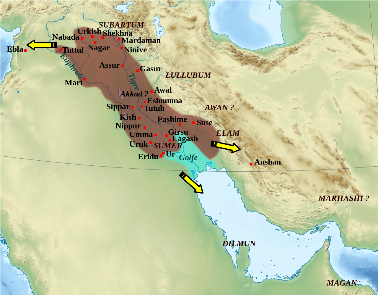
English: Mapa que mostra l'extensió aproximada de l'imperi Accadi durant el regnat de Narâm-Sîn (2254-2218 a.C. en la cronologia breu). Français : Carte de l'extension approximative de l'empire d'Akkad sous le règne de Narâm-Sîn (2254-2218 av. J.-C. selon la chronologie moyenne), et des directions des campagnes militaires extérieures. Sources : B. Lafont et M. Sauvage dans M. Sauvage (dir.), Atlas historique du Proche-Orient ancien, Paris, Les Belles Lettres, 2020, p. 70 ; P. Michalowski, « The Kingdom of Akkad in Contact with the World », dans The Oxford History of the Ancient Near East, Volume 1: From the Beginnings to Old Kingdom Egypt and the Dynasty of Akkad, New York, Oxford University Press, 2020, p. 688 fig. 10.1. |
| Datum | (UTC) |
| Izvor | |
| Autor |
|
| Ostale verzije |
File:Empire akkad.svg has 2 translations.
Other related versions: []
|


| Camera location | | View this and other nearby images on: OpenStreetMap |
|---|
|
|
Ova SVG datoteka koristi ugrađeni tekst koji se može lako prevesti na vaš jezik. Više detalja. Za SVG slike možete koristiti [toolforge:svgtranslate/File:Empire_akkad.svglink ovu stranicu] kako biste je preveli na vaš jezik. |
This file is translated using SVG For most Wikipedia projects, you can embed the file normally (without a To translate the text into your language, you can use the SVG Translate tool. Alternatively, you can download the file to your computer, add your translations using whatever software you're familiar with, and re-upload it with the same name. You will find help in Graphics Lab if you're not sure how to do this. |
| This is a retouched picture, which means that it has been digitally altered from its original version. Modifications: Ajout des villes, du contour approximatif de l'empire.. The original can be viewed here: Middle East topographic map-blank.svg:
|
Licenciranje
- Slobodni ste:
- da dijelite – da kopirate, distributirate i prenosite djelo
- da remiksate – da prilagodite djelo
- Pod sljedećim uslovima:
- pripisivanje – Morate pripisati odgovarajuće autorske zasluge, osigurati link ka licenci i naznačiti jesu li napravljene izmjene. To možete uraditi na bilo koji razumni način, ali ne tako da se sugerira da davalac licence odobrava Vas ili Vašu upotrebu njegovog djela.
- dijeli pod istim uslovima – Ako mijenjate, transformišete ili nadograđujete ovaj materijal, morate ga objaviti i distribuirati samo pod istom ili sličnom licencom poput ove.

|
Dozvoljeno je kopirati, distribuirati i/ili mijenjati ovaj članak pod uslovima navedenim u GNU licenci za slobodnu dokumentaciju, verzija 1.2 ili kasnijom verzijom izdatom od Free Software Foundation; bez nepromjenljivih dijelova, te bez sadržaja na naslovnoj i zadnjoj strani. Kopija licence se nalazi pod poglavljem GNU Free Documentation License. |
Originalni zapisnik postavljanja
This image is a derivative work of the following images:
- File:Middle_East_topographic_map-blank.svg licensed with Cc-by-sa-3.0,2.5,2.0,1.0, GFDL
- 2010-11-03T17:52:56Z Sémhur 3097x1938 (10510751 Bytes) == {{int:filedesc}} == {{Information |Description={{Multilingual description |en= Blank physical map of the [[:en:Middle East|Middle East]] |fr= Carte physique vierge du [[:fr:Moyen-Orient|Moyen-Orient]]. }} |Source={{own}}.
Uploaded with derivativeFX
Historija datoteke
Kliknite na datum/vrijeme da vidite verziju datoteke iz tog vremena.
| Datum/vrijeme | Smanjeni pregled | Dimenzije | Korisnik | Komentar | |
|---|---|---|---|---|---|
| trenutno | 03:21, 19 februar 2024 | | 1.475 × 1.149 (2,34 MB) | Manlleus | File uploaded using svgtranslate tool (https://svgtranslate.toolforge.org/). Added translation for ca. |
| 16:42, 6 maj 2023 |  | 1.475 × 1.149 (2,32 MB) | Zunkir | + Awal | |
| 19:18, 11 mart 2023 |  | 1.475 × 1.149 (2,32 MB) | Zunkir | taille police | |
| 18:58, 11 mart 2023 |  | 1.475 × 1.149 (2,32 MB) | Zunkir | contours, villes | |
| 13:49, 29 oktobar 2011 |  | 1.475 × 1.149 (2,33 MB) | Zunkir | Police. | |
| 22:32, 28 oktobar 2011 |  | 1.475 × 1.149 (2,32 MB) | Zunkir | Reverted to version as of 10:06, 7 January 2011 | |
| 22:31, 28 oktobar 2011 |  | 1.475 × 1.149 (2,33 MB) | Zunkir | Police. | |
| 12:06, 7 januar 2011 |  | 1.475 × 1.149 (2,32 MB) | Sémhur | Remove coloured boxes | |
| 00:31, 12 novembar 2010 |  | 1.475 × 1.149 (2,33 MB) | Zunkir | New new try | |
| 00:13, 12 novembar 2010 |  | 1.475 × 1.149 (2,33 MB) | Zunkir | Again ... |
Upotreba datoteke
Sljedeća stranica koristi ovu datoteku:
Globalna upotreba datoteke
Sljedeći wikiji koriste ovu datoteku:
- Upotreba na af.wikipedia.org
- Upotreba na ar.wikipedia.org
- Upotreba na arz.wikipedia.org
- Upotreba na ast.wikipedia.org
- Upotreba na azb.wikipedia.org
- Upotreba na az.wikipedia.org
- Upotreba na bg.wikipedia.org
- Upotreba na bn.wikipedia.org
- Upotreba na br.wikipedia.org
- Upotreba na ca.wikipedia.org
- Upotreba na ckb.wikipedia.org
- Upotreba na cs.wikipedia.org
- Upotreba na da.wikipedia.org
- Upotreba na el.wikipedia.org
- Upotreba na en.wikipedia.org
- Akkadian Empire
- Shar-Kali-Sharri
- Gutian rule in Mesopotamia
- Naram-Sin of Akkad
- List of conflicts in Asia
- History of Mesopotamia
- Middle Eastern empires
- Rimush
- User:RekonDog/Sandbox
- Sargon of Akkad
- User:RekonDog/sandbox
- Armi (Syria)
- Akkad (city)
- User:History of Persia/sandbox
- User:Monochrome Monitor/Under Construction
- Early Assyrian period
- King of the Universe
- King of Sumer and Akkad
- Abalgamash
- User:SomeGuyWhoRandomlyEdits/History of Sumer
- User:SomeGuyWhoRandomlyEdits/List of conflicts in the Near East
Pogledajte globalne upotrebe ove datoteke.