
Datoteka:Everest-3D-Map-Type-EN.jpg

Veličina ovog prikaza: 800 × 600 piksela. Ostale rezolucije: 320 × 240 piksela | 640 × 480 piksela | 1.024 × 768 piksela | 1.280 × 960 piksela | 2.560 × 1.920 piksela | 5.000 × 3.750 piksela.
Izvorna datoteka (5.000 × 3.750 piksela, veličina datoteke: 4,28 MB, MIME tip: image/jpeg)
| Ova datoteka je s Wikimedia Commonsa. Opis s njene stranice opisa datoteke prikazan je ispod. Commons je skladište slobodnih medija i datoteka za sve projekte fondacije Wikimedia. Možete i Vi pomoći. |
Sažetak
| Opis |
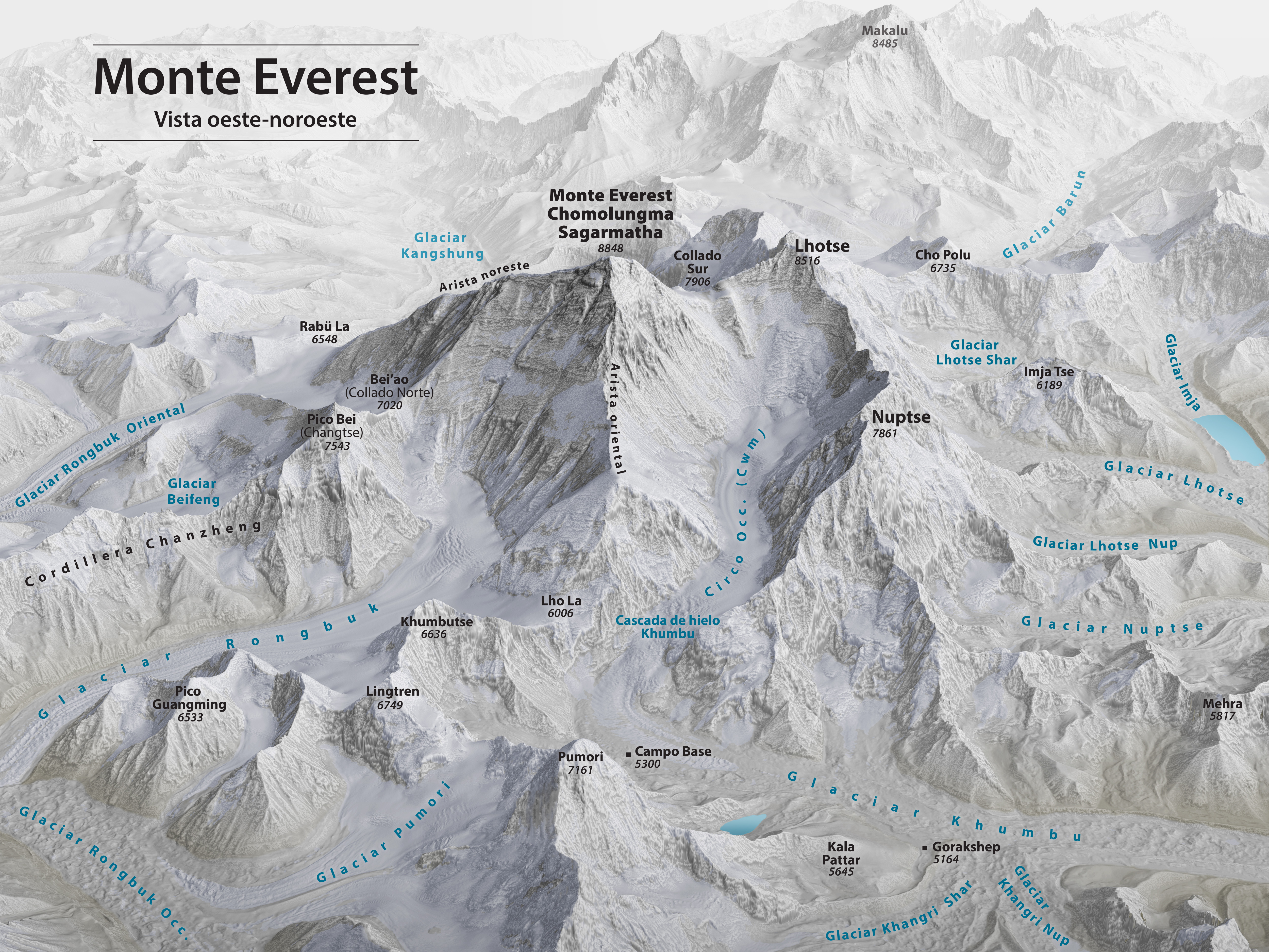
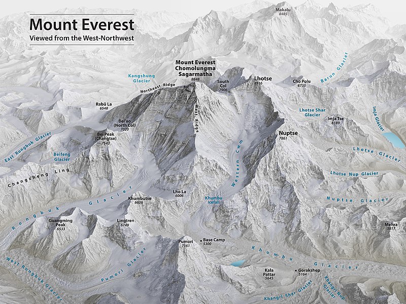
English: Mount Everest 3D Map by Tom Patterson, with English annotation, based on data from the US National Snow and Ice Data Center and Landsat 8. |
||
| Datum | |||
| Izvor | http://shadedrelief.com/Everest-3D-Map | ||
| Autor | Tom Patterson | ||
| Ostale verzije |
|

Assessment
|

Licenciranje
| Ova datoteka je dostupna pod licencom Creative Commons CC0 1.0 Univerzalnom Posvetom Javne Domene. | |
| Osoba koja je učestvovala u radu na ovom dokumentu posvetila je rad javnoj domeni odricanjem od svih svojih prava na taj rad širom svijeta po zakonu o autorskim pravima i svim povezanim zakonskim pravima koja bi imao/imala, u mjeri dopuštenoj zakonom. Možete kopirati, mijenjati, distribuirati i prilagođavati rad, čak i u komercijalne svrhe, bez traženja dopuštenja.
|
License note: Source page at this link archived here states: "Terms of Use - The maps on this page are in the public domain. You may use them any way you like, including modifying the content, digital and print reproduction, and selling them for profit. Consider these maps as yours."
Historija datoteke
Kliknite na datum/vrijeme da vidite verziju datoteke iz tog vremena.
| Datum/vrijeme | Smanjeni pregled | Dimenzije | Korisnik | Komentar | |
|---|---|---|---|---|---|
| trenutno | 02:53, 19 novembar 2020 | | 5.000 × 3.750 (4,28 MB) | Cmglee | Uploaded a work by Tom Patterson from http://shadedrelief.com/Everest-3D-Map with UploadWizard |
Upotreba datoteke
Sljedeća stranica koristi ovu datoteku:
Globalna upotreba datoteke
Sljedeći wikiji koriste ovu datoteku:
- Upotreba na ca.wikipedia.org
- Upotreba na ckb.wikipedia.org
- Upotreba na en.wikipedia.org
- Mount Everest
- Timeline of Mount Everest expeditions
- Wikipedia:WikiProject Nepal
- Portal:Nepal
- Wikipedia:WikiProject China/Featured and good content
- User:Cmglee
- Wikipedia:Featured pictures/Diagrams, drawings, and maps/Maps
- Wikipedia:WikiProject Geology/Recognized content
- 1953 British Mount Everest expedition
- Wikipedia:WikiProject Geology/Automated list of recognized content
- Talk:Mount Everest/Archive 6
- Portal:Nepal/Recognized content
- Portal:Sports/Recognized content
- Wikipedia:WikiProject Nepal/Recognized content
- Wikipedia:Featured pictures thumbs/69
- Wikipedia:Featured picture candidates/November-2020
- Wikipedia:Featured picture candidates/Mount Everest 3D map
- Wikipedia:Wikipedia Signpost/2020-12-28/Featured content
- Wikipedia:Wikipedia Signpost/Single/2020-12-28
- User:Evad37/Wikipedia:Wikipedia Signpost/Single/2020-12-28
- User talk:Cmglee/archive2020
- Wikipedia:WikiProject Mountains/Recognized content
- Wikipedia:Picture of the day/May 2023
- Template:POTD/2023-05-29
- Wikipedia:Main Page history/2023 May 29
- Wikipedia:Main Page history/2023 May 29b
- Upotreba na ext.wikipedia.org
- Upotreba na fi.wikipedia.org
- Upotreba na fr.wikipedia.org
- Upotreba na id.wikipedia.org
- Upotreba na nl.wikipedia.org
- Upotreba na sh.wikipedia.org