
Datoteka:Is-map.PNG
Veličina ovog prikaza: 276 × 598 piksela. Ostale rezolucije: 110 × 240 piksela | 329 × 713 piksela.
Izvorna datoteka (329 × 713 piksela, veličina datoteke: 27 KB, MIME tip: image/png)
| Ova datoteka je s Wikimedia Commonsa. Opis s njene stranice opisa datoteke prikazan je ispod. Commons je skladište slobodnih medija i datoteka za sve projekte fondacije Wikimedia. Možete i Vi pomoći. |
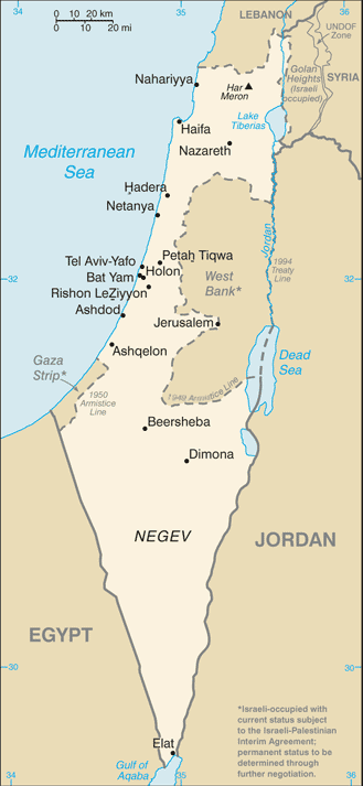
| Opis |
Русский: Карта Израиля |
| Datum | (2004) |
| Izvor | CIA-WF |
| Autor | CIA |
| Ostale verzije |
.png)
This image is in the public domain because it contains materials that originally came from the United States Central Intelligence Agency's World Factbook.
|
 |
Historija datoteke
Kliknite na datum/vrijeme da vidite verziju datoteke iz tog vremena.
| Datum/vrijeme | Smanjeni pregled | Dimenzije | Korisnik | Komentar | |
|---|---|---|---|---|---|
| trenutno | 09:25, 21 juni 2007 | | 329 × 713 (27 KB) | Hoshie | Updated map of Israel from the CIA World Factbook, 14 June 07 rev. Src: https://www.cia.gov/library/publications/the-world-factbook/maps/is-map.gif |
| 16:27, 16 juni 2005 |  | 330 × 715 (24 KB) | Csörföly D | Category:Maps of Israel {{PD-USGov-CIA-PD}} |
Upotreba datoteke
Sljedeća stranica koristi ovu datoteku:
Globalna upotreba datoteke
Sljedeći wikiji koriste ovu datoteku:
- Upotreba na ar.wikipedia.org
- Upotreba na bg.wikipedia.org
- Upotreba na bn.wikipedia.org
- Upotreba na ca.wikipedia.org
- Upotreba na de.wikipedia.org
- Upotreba na en.wikipedia.org
- History of Israel
- Israeli Declaration of Independence
- Israeli settlement
- Zionism
- Israeli–Palestinian conflict
- Law of Return
- Demographic history of Palestine (region)
- User talk:Theblackbay
- Israel
- Chronology of Aliyah in modern times
- History of Palestine
- Timeline of the name Palestine
- Template:Zionism and the Land of Israel
- Land of Israel
- Module:Location map/data/Israel/doc
- Module:Location map/data/Israel
- User:প্রলয়স্রোত/sandbox
- List of journalists killed during the Israeli–Palestinian conflict
- Israeli war crimes
- Wikipedia:In the news/Posted/February 2005
- Hamas war crimes
- Upotreba na en.wikinews.org
- Upotreba na es.wikipedia.org
- Upotreba na eu.wikipedia.org
- Upotreba na fi.wikipedia.org
- Upotreba na fi.wikivoyage.org
- Upotreba na fr.wikipedia.org
- Upotreba na fr.wikinews.org
- Upotreba na hif.wikipedia.org
- Upotreba na hi.wikipedia.org
- Upotreba na hr.wikipedia.org
- Upotreba na hy.wikipedia.org
- Upotreba na ilo.wikipedia.org
- Upotreba na it.wikinews.org
Pogledajte globalne upotrebe ove datoteke.