
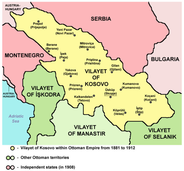
Datoteka:Vilayet of Kosovo (1881–1912) map.png

Veličina ovog prikaza: 645 × 599 piksela. Ostale rezolucije: 258 × 240 piksela | 517 × 480 piksela | 820 × 762 piksela.
Izvorna datoteka (820 × 762 piksela, veličina datoteke: 74 KB, MIME tip: image/png)
| Ova datoteka je s Wikimedia Commonsa. Opis s njene stranice opisa datoteke prikazan je ispod. Commons je skladište slobodnih medija i datoteka za sve projekte fondacije Wikimedia. Možete i Vi pomoći. |
_map.png)
Sažetak
VILAJETI I KOSOVËS NËN PERANDORINË OSMANE NGA 1881 DERI MË 1912
Source and licence

|
This map has been uploaded by Electionworld from en.wikipedia.org to enable the |
| Ovaj rad je objavljen u javno vlasništvo od strane autora PANONIAN. Ovo se primjenjuje širom svijeta. U nekim državama ovo zakonski nije moguće; u tom slučaju: |
References
Main reference:
- Created according to historical map from this book: Petrit Imami, Srbi i Albanci kroz vekove, Beograd, 2000.
Secondary references with similar maps:
- Noel Malcolm, Kosovo - A Short History, Pan Books, London, 2002.
- Školski istorijski atlas, Zavod za izdavanje udžbenika SR Srbije, Beograd, 1970.
- Sve srpske mape - od šestog veka do Pariza, Specijalno izdanje BLICA, Decembar 1995. godine.
- http://terkepek.adatbank.transindex.ro/kepek/netre/95.gif
- http://www.panmacedonian.info/macedonism_thesis_files/Macedonism%20of%20the%20Slavs_img_19.jpg
- http://www.zum.de/whkmla/histatlas/balkans/rumelia1891t.gif
- http://www.kosovo.net/sk/rastko-kosovo/istorija/kosovo_chronicles/kc_figure1.gif
- http://www.hri.org/docs/macque/map3.gif
- http://remmm.revues.org/docannexe/image/305/img-1-small480.png
- http://www.cairn.info/loadimg.php?FILE=GMCC/GMCC_202/GMCC_202_0113/fullGMCC_id9782130527213_pu2001-02d_pa01-da16_art07_img001.jpg
Historija datoteke
Kliknite na datum/vrijeme da vidite verziju datoteke iz tog vremena.
| Datum/vrijeme | Smanjeni pregled | Dimenzije | Korisnik | Komentar | |
|---|---|---|---|---|---|
| trenutno | 15:16, 11 septembar 2012 | | 820 × 762 (74 KB) | PANONIAN | {{Information |Description ={{en|1=cosmetic changes}} |Source =cosmetic changes |Author =cosmetic changes |Date = |Permission = |other_versions = }} |
| 09:17, 6 april 2011 |  | 762 × 719 (61 KB) | PANONIAN | Reverted to version as of 08:44, 5 April 2011 - trying to solve thumbnail problem | |
| 09:14, 6 april 2011 |  | 762 × 719 (61 KB) | PANONIAN | Reverted to version as of 08:44, 5 April 2011 - trying to solve thumbnail problem | |
| 09:14, 6 april 2011 |  | 762 × 719 (64 KB) | PANONIAN | Reverted to version as of 20:05, 2 June 2009 - trying to solve thumbnail problem | |
| 10:44, 5 april 2011 |  | 762 × 719 (61 KB) | PANONIAN | aesthetical improvement | |
| 22:05, 2 juni 2009 |  | 762 × 719 (64 KB) | PANONIAN | ||
| 01:31, 22 decembar 2006 |  | 624 × 516 (185 KB) | Electionworld | {{ew|en|PANONIAN}} {{PD-user|PANONIAN}} Category:Maps of Kosovo |
Upotreba datoteke
Sljedeće 3 stranice koriste ovu datoteku:
Globalna upotreba datoteke
Sljedeći wikiji koriste ovu datoteku:
- Upotreba na af.wikipedia.org
- Upotreba na ast.wikipedia.org
- Upotreba na be.wikipedia.org
- Upotreba na bg.wikipedia.org
- Upotreba na bn.wikipedia.org
- Upotreba na br.wikipedia.org
- Upotreba na ca.wikipedia.org
- Upotreba na de.wikipedia.org
- Upotreba na en.wikipedia.org
- Upotreba na es.wikipedia.org
- Upotreba na fi.wikipedia.org
- Upotreba na fr.wikipedia.org
- Upotreba na gl.wikipedia.org
- Upotreba na hr.wikipedia.org
- Upotreba na ht.wikipedia.org
- Upotreba na hu.wikipedia.org
- Upotreba na it.wikipedia.org
- Upotreba na ja.wikipedia.org
- Upotreba na lt.wikipedia.org
- Upotreba na lv.wikipedia.org
- Upotreba na mk.wikipedia.org
- Upotreba na nl.wikipedia.org
- Upotreba na no.wikipedia.org
- Upotreba na pl.wikipedia.org
- Upotreba na pt.wikipedia.org
- Upotreba na ro.wikipedia.org
Pogledajte globalne upotrebe ove datoteke.
_map.png)
_map.png)