
Datoteka:Kukenan Roraima GS.jpg

Izvorna datoteka (4.851 × 1.533 piksela, veličina datoteke: 3,64 MB, MIME tip: image/jpeg)
| Ova datoteka je s Wikimedia Commonsa. Opis s njene stranice opisa datoteke prikazan je ispod. Commons je skladište slobodnih medija i datoteka za sve projekte fondacije Wikimedia. Možete i Vi pomoći. |
Sažetak
| Opis |
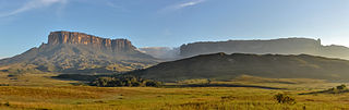
English: Morning view of Kukenan and Roraima tepuis, from Tëk river camp (river visible in the image), in Gran Sabana, Venezuela. Roraima tepui is actually some 100 mts higher than Kukenan, but due to the perspective of the picture, it looks like it is lower.
Español: Vista matutina de los tepuys Kukenan y Roraima, desde el campamente del río Tëk (con el río visible en la imagen), en la Gran Sabana, Venezuela. El tepuy Roraima es en realidad unos cien metros más alto que el Kukenan, aunque por la perspectiva de la foto, parece lo contrario.
Français : Vue matinale sur le Tepuy Kukenan et le Mont Roraima, depuis le camp de la rivière Tëk, dans la Gran Sabana (Vénézuela). Le Roraima Fait 100 m de plus que le Kukenan, bien qu'il apparaisse moins haut sur l'image, à cause de la perspective.
Bosanski: Jutarnja panorama Kukenana i tepui planine Roraima, iz riječnog kampa Tëk, Gran Sabana, Venecuela.
Italiano: Panorama al mattino dei tepui di Kukenan e Roraima dal campo sul fiume Tëk, Gran Sabana in Venezuela.
|
|||
| Datum | ||||
| Izvor | Vlastito djelo | |||
| Autor | Paolo Costa Baldi | |||
| Dopuštenje (Naknadno korištenje ove datoteke) |
|
| Camera location | | View this and other nearby images on: OpenStreetMap |
|---|
|
This image was selected as picture of the day on Wikimedia Commons for 10 July 2015. It was captioned as follows: Other languages:
Bosanski: Jutarnja panorama Kukenana i tepui planine Roraima, iz riječnog kampa Tëk, Gran Sabana, Venecuela. Español: Vista matutina de los tepuys Kukenan y Roraima, desde el campamente del río Tëk (con el río visible en la imagen), en la Gran Sabana, Venezuela. Italiano: Panorama al mattino dei tepui di Kukenan e Roraima dal campo sul fiume Tëk, Gran Sabana in Venezuela. |
Licenciranje
- Slobodni ste:
- da dijelite – da kopirate, distributirate i prenosite djelo
- da remiksate – da prilagodite djelo
- Pod sljedećim uslovima:
- pripisivanje – Morate pripisati odgovarajuće autorske zasluge, osigurati link ka licenci i naznačiti jesu li napravljene izmjene. To možete uraditi na bilo koji razumni način, ali ne tako da se sugerira da davalac licence odobrava Vas ili Vašu upotrebu njegovog djela.
- dijeli pod istim uslovima – Ako mijenjate, transformišete ili nadograđujete ovaj materijal, morate ga objaviti i distribuirati samo pod istom ili sličnom licencom poput ove.

|
Dozvoljeno je kopirati, distribuirati i/ili mijenjati ovaj članak pod uslovima navedenim u GNU licenci za slobodnu dokumentaciju, verzija 1.2 ili kasnijom verzijom izdatom od Free Software Foundation; bez nepromjenljivih dijelova, te bez sadržaja na naslovnoj i zadnjoj strani. Kopija licence se nalazi pod poglavljem GNU Free Documentation License. |
| Annotations | This image is annotated: View the annotations at Commons |
Historija datoteke
Kliknite na datum/vrijeme da vidite verziju datoteke iz tog vremena.
| Datum/vrijeme | Smanjeni pregled | Dimenzije | Korisnik | Komentar | |
|---|---|---|---|---|---|
| trenutno | 05:42, 20 oktobar 2011 | 4.851 × 1.533 (3,64 MB) | Paolostefano1412 | {{Information |Description ={{en|1=Morning view of Kukenan and Roraima tepuis, from River Tëk camp (river visible in the image).}} {{es|1=Vista matutina de los tepuys Kukenan y Roraima, desde el campamente del río Tëk (con el río visible en la imag |
Upotreba datoteke
Sljedeća stranica koristi ovu datoteku:
Globalna upotreba datoteke
Sljedeći wikiji koriste ovu datoteku:
- Upotreba na ast.wikipedia.org
- Upotreba na av.wikipedia.org
- Upotreba na az.wikipedia.org
- Upotreba na be-tarask.wikipedia.org
- Upotreba na bn.wikipedia.org
- Upotreba na crh.wikipedia.org
- Upotreba na cs.wikipedia.org
- Upotreba na cv.wikipedia.org
- Upotreba na cy.wikipedia.org
- Upotreba na da.wikipedia.org
- Upotreba na de.wikipedia.org
- Upotreba na en.wikipedia.org
- Wikipedia:WikiProject Protected areas
- Gran Sabana
- Portal:Venezuela
- Wikipedia:Featured pictures/Places/Panorama
- Talk:Gran Sabana
- User talk:Paolostefano1412
- Wikipedia:WikiProject Geology/Recognized content
- Wikipedia:Featured pictures thumbs/33
- Wikipedia:Featured picture candidates/January-2013
- User talk:Razr Nation/2013/2
- Wikipedia:Featured picture candidates/Kukenan Roraima GS
- User:Razr Nation/FPs
- Distribution of Heliamphora
- Eastern Tepuis
- Wikipedia:Picture of the day/May 2014
- User talk:Razr Nation/2014/4
- Template:POTD/2014-05-29
- Wikipedia:Main Page history/2014 May 29
- Wikipedia:WikiProject Geology/Automated list of recognized content
- Raleigh's El Dorado expedition
- Portal:Venezuela/Recognized content
- Upotreba na en.wikivoyage.org
- Upotreba na es.wikipedia.org
- La Gran Sabana
- Anexo:Patrimonio de la Humanidad en América Latina y el Caribe
- Wikipedia:Imágenes destacadas/Lugares/Sudamérica
- Wikipedia:Recurso del día/501 - 600
- Wikipedia:Candidatos a recursos destacados/Diciembre-2011
- Wikipedia:Candidatos a recursos destacados/Kukenan Roraima GS.jpg
- Plantilla:RDD/556
- Wikipedia:Recurso del día/enero de 2012
- Wikipedia:Recurso del día/febrero de 2013
- Usuario discusión:Eduardosalg/Archivo57/Archivo56/Archivo39
- Usuario:JosueCarrion
- Usuario:Eduardosalg/Vitrina
- Usuario:Leanex77
- Wikipedia:Recurso del día/abril de 2015
Pogledajte globalne upotrebe ove datoteke.