
Datoteka:Map showing counties under the new Kenyan constitution.gif

Izvorna datoteka (620 × 804 piksela, veličina datoteke: 56 KB, MIME tip: image/gif)
| Ova datoteka je s Wikimedia Commonsa. Opis s njene stranice opisa datoteke prikazan je ispod. Commons je skladište slobodnih medija i datoteka za sve projekte fondacije Wikimedia. Možete i Vi pomoći. |
Sažetak
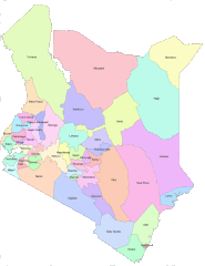
| Opis |
English: Areas that are covered by Counties in the new Kenya constitution |
| Datum | |
| Izvor | https://opendata.go.ke/facet/counties |
| Autor | Kenya Open Data Project |
Licenciranje

|
The copyright holder of this work allows anyone to use it for any purpose including unrestricted redistribution, commercial use, and modification.
Usage notes:
|
All the works in the Kenya open data website are free for use either commercially or non commercially as it is stated at the terms and conditions of the website. I believe that this is a non commercial use on commons.
Historija datoteke
Kliknite na datum/vrijeme da vidite verziju datoteke iz tog vremena.
| Datum/vrijeme | Smanjeni pregled | Dimenzije | Korisnik | Komentar | |
|---|---|---|---|---|---|
| trenutno | 08:48, 28 juni 2012 | | 620 × 804 (56 KB) | Kagundu |
Upotreba datoteke
Sljedeća stranica koristi ovu datoteku:
Globalna upotreba datoteke
Sljedeći wikiji koriste ovu datoteku:
- Upotreba na ab.wikipedia.org
- Upotreba na ba.wikipedia.org
- Upotreba na bg.wikipedia.org
- Upotreba na cs.wikipedia.org
- Upotreba na cy.wikipedia.org
- Upotreba na en.wikipedia.org
- Upotreba na eo.wikipedia.org
- Upotreba na et.wikipedia.org
- Upotreba na eu.wikipedia.org
- Upotreba na fa.wikipedia.org
- Upotreba na fi.wikipedia.org
- Upotreba na fr.wikipedia.org
- Upotreba na he.wikipedia.org
- Upotreba na hu.wikipedia.org
- Upotreba na id.wikipedia.org
- Upotreba na incubator.wikimedia.org
- Upotreba na it.wikipedia.org
- Upotreba na ko.wikipedia.org
- Upotreba na ku.wikipedia.org
- Upotreba na my.wikipedia.org
- Upotreba na pl.wikipedia.org
- Upotreba na ru.wikipedia.org
- Кения
- Ньянза
- Западная провинция (Кения)
- Рифт-Валли
- Северо-Восточная провинция (Кения)
- Центральная провинция (Кения)
- Прибрежная провинция (Кения)
- Восточная провинция (Кения)
- Бусиа (округ, Кения)
- Найроби (провинция Кении)
- Административное деление Кении
- Гарисса (округ)
- Нарок (округ)
- Ваджир (округ)
- Шаблон:Административное деление Кении
- Занзойский округ
- Вихига (округ)
- Западный покотский округ
- Исиоло (округ)
Pogledajte globalne upotrebe ove datoteke.