
Datoteka:Mohammad adil-Rashidun-empire-at-its-peak-close.PNG
Veličina ovog prikaza: 800 × 388 piksela. Ostale rezolucije: 320 × 155 piksela | 640 × 310 piksela | 1.196 × 580 piksela.
Izvorna datoteka (1.196 × 580 piksela, veličina datoteke: 58 KB, MIME tip: image/png)
| Ova datoteka je s Wikimedia Commonsa. Opis s njene stranice opisa datoteke prikazan je ispod. Commons je skladište slobodnih medija i datoteka za sve projekte fondacije Wikimedia. Možete i Vi pomoći. |

|
This map image could be re-created using vector graphics as an SVG file. This has several advantages; see Commons:Media for cleanup for more information. If an SVG form of this image is available, please upload it and afterwards replace this template with
{{vector version available|new image name}}.
It is recommended to name the SVG file “Mohammad adil-Rashidun-empire-at-its-peak-close.svg”—then the template Vector version available (or Vva) does not need the new image name parameter. |
Sažetak
| Opis |
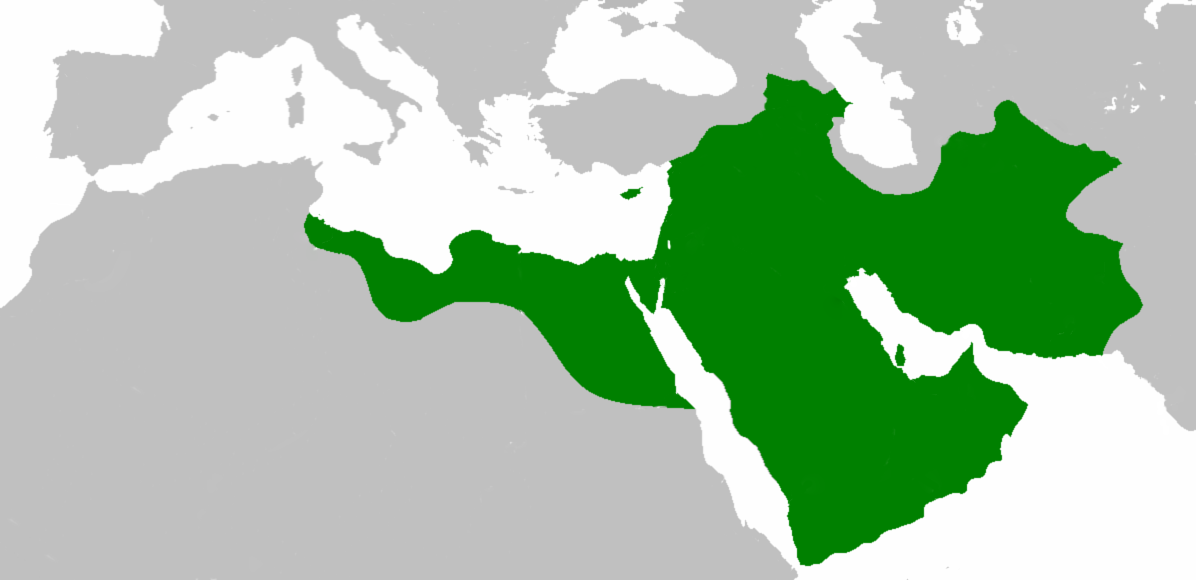
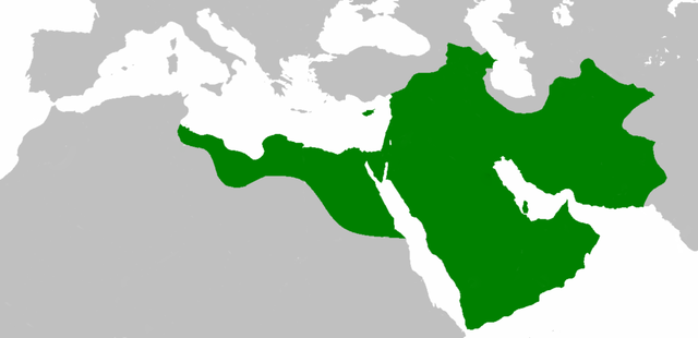
العربية: اتساع الدولة الإسلامية في عهد الخليفة عثمان بن عفان English: Empire of the Rashidun Caliphate at its peak. |
|||
| Datum | 21 juli 2007 (original upload date) | |||
| Izvor | Transferred from en.wikipedia to Commons. | |||
| Autor | Mohammad adil at engleski Wikipedia | |||
| Ostale verzije |
|

Licenciranje
Mohammad adil from en.wikipedia.org, vlasnik autorskog prava ovog djela, ovdje ga objavljujem pod sljedećom licencom:
| Ova datoteka je licencirana pod Creative Commons Attribution-Share Alike 3.0 neportiranom licencom. Subject to disclaimers. | ||
| Pripisivanje: Mohammad adil from en.wikipedia.org | ||
| ||
| Ova oznaka licence je dodana na ovu datoteku kao dio GFDL ažuriranja licence. |

|
Dozvoljeno je kopirati, distribuirati i/ili mijenjati ovaj članak pod uslovima navedenim u GNU licenci za slobodnu dokumentaciju, verzija 1.2 ili kasnijom verzijom izdatom od Free Software Foundation; bez nepromjenljivih dijelova, te bez sadržaja na naslovnoj i zadnjoj strani. Kopija licence se nalazi pod poglavljem GNU Free Documentation License. Subject to disclaimers. |
Originalni zapisnik postavljanja
The original description page was here. All following user names refer to en.wikipedia.
- 2010-04-25 09:06 Cplakidas 1196×580× (50435 bytes) whoops
- 2010-04-25 08:59 Cplakidas 1196×580× (50513 bytes) corrections: Crete, Rhodes, Sicily, Cilicia, W. Armenia & Iberia were raided and invaded, but not permanently occupied until much later. In Africa, the Exarchate of Carthage still controlled most of Tunisia, and no Arabs had yet reached Spain.
- 2009-05-01 06:26 Mohammad adil 1196×580× (46594 bytes) {{GFDL-self-with-disclaimers}}
- 2009-01-26 14:13 Mohammad adil 1196×580× (95308 bytes)
- 2008-03-28 21:12 Mohammad adil 1400×680× (48613 bytes) {{GFDL-self-with-disclaimers}}
- 2008-03-28 21:08 Mohammad adil 1400×680× (48472 bytes) {{GFDL-self-with-disclaimers}}
- 2007-07-21 19:15 Mohammad adil 1400×690× (47455 bytes) {{GFDL-self-with-disclaimers}}
Historija datoteke
Kliknite na datum/vrijeme da vidite verziju datoteke iz tog vremena.
| Datum/vrijeme | Smanjeni pregled | Dimenzije | Korisnik | Komentar | |
|---|---|---|---|---|---|
| trenutno | 21:59, 10 decembar 2018 | | 1.196 × 580 (58 KB) | عبد الله | Reverted to version as of 19:41, 10 December 2018 (UTC) |
| 21:57, 10 decembar 2018 |  | 1.196 × 580 (58 KB) | عبد الله | إزالة خطوط مزعجة | |
| 21:41, 10 decembar 2018 |  | 1.196 × 580 (58 KB) | عبد الله | إزالة خطوط مضايقة | |
| 06:29, 12 decembar 2017 |  | 1.196 × 580 (37 KB) | Swazzo | Reverted to version as of 23:30, 2 May 2014 (UTC) unnecessary | |
| 13:25, 9 decembar 2017 |  | 1.196 × 580 (44 KB) | Mehrdad 12 | [[]][[Media:]]]] | |
| 01:30, 3 maj 2014 |  | 1.196 × 580 (37 KB) | HistoryofIran | Corrected map; regions such as Ghur was not under Rashidun control. | |
| 11:27, 19 oktobar 2012 |  | 1.196 × 580 (45 KB) | Cplakidas | correction: the Muslims had not yet established themselves beyond the Caucasus, Derbent and its environs were conquered in the 8th century | |
| 10:51, 25 juli 2012 |  | 1.196 × 580 (46 KB) | محک | see also:File:Age of Caliphs.png and:[http://en.wikipedia.org/wiki/Mazandaran#Post_Islamic_history] and:tapuria history book (Ibn Esfandiyar) | |
| 11:07, 17 juni 2012 |  | 1.196 × 580 (49 KB) | OgreBot | (BOT): Reverting to most recent version before archival | |
| 11:06, 17 juni 2012 |  | 1.196 × 580 (49 KB) | OgreBot | (BOT): Uploading old version of file from en.wikipedia; originally uploaded on 2010-04-25 09:06:38 by Cplakidas |
Upotreba datoteke
Sljedeća stranica koristi ovu datoteku:
Globalna upotreba datoteke
Sljedeći wikiji koriste ovu datoteku:
- Upotreba na ace.wikipedia.org
- Upotreba na af.wikipedia.org
- Upotreba na ar.wikipedia.org
- عثمان بن عفان
- الخلفاء الراشدون
- زيد بن ثابت
- معركة أجنادين
- الحسن بن علي
- الحسين بن علي
- بلال بن رباح
- سقيفة بني ساعدة
- حروب الردة
- الفسطاط
- خالد بن الوليد
- أبو هريرة
- أبو الأسود الدؤلي
- مارية القبطية
- عمرو بن العاص
- سلمان الفارسي
- أسيد بن حضير
- سعد بن أبي وقاص
- عائشة بنت أبي بكر
- أم حبيبة
- سودة بنت زمعة
- أم سلمة
- الزبير بن العوام
- سعيد بن زيد
- سعد بن عبادة
- عبد الله بن عمر بن الخطاب
- أبان بن سعيد بن العاص
- أبو أيوب الأنصاري
- فتنة مقتل عثمان
- القوقاز
- عبد الله بن الزبير
- أبان بن عثمان بن عفان
- أنس بن مالك
- يزيد بن أبي سفيان
- معركة اليرموك
- معركة ذات الصواري
- طلحة بن عبيد الله
- المغيرة بن شعبة
- عبد الله بن سبأ
- زينب بنت جحش
- زينب بنت خزيمة
- جويرية بنت الحارث
- صفية بنت حيي بن أخطب
- ميمونة بنت الحارث
- أبو سفيان بن حرب
- أبو ذر الغفاري
- عبد الله بن عباس
Pogledajte globalne upotrebe ove datoteke.