
Datoteka:NUTS 3 regions of Northern Ireland map.svg

Veličina ovog PNG pregleda za ovu SVG datoteku: 705 × 599 piksela. Ostale rezolucije: 282 × 240 piksela | 565 × 480 piksela | 903 × 768 piksela | 1.205 × 1.024 piksela | 2.409 × 2.048 piksela | 1.208 × 1.027 piksela.
Izvorna datoteka (SVG datoteka, nominalno 1.208 × 1.027 piksela, veličina datoteke: 163 KB)
| Ova datoteka je s Wikimedia Commonsa. Opis s njene stranice opisa datoteke prikazan je ispod. Commons je skladište slobodnih medija i datoteka za sve projekte fondacije Wikimedia. Možete i Vi pomoći. |
Sažetak
| Opis |
Deutsch: Karte von Nordirland: NUTS-Raumeinheiten auf den Ebenen NUTS3.
Quadratische Plattkarte, N-S-Streckung 170 %. Geographische Begrenzung der Karte:
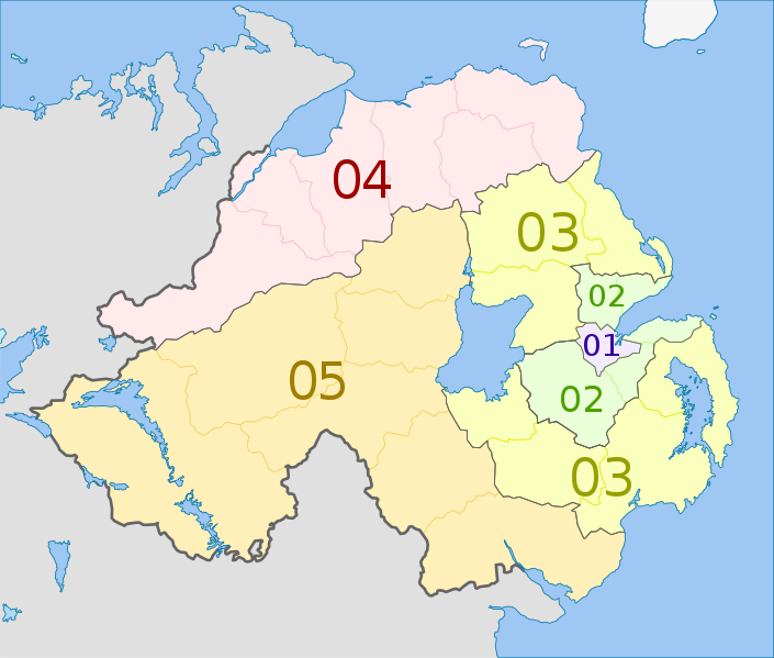
English: Map of the NUTS 3 regions of Northern Ireland.
Equirectangular projection, N/S stretching 170 %. Geographic limits of the map:
|
| Datum | (UTC) |
| Izvor |
This file was derived from: Northern Ireland location map.svg: |
| Autor |
|
| NUTS 1 | Code | NUTS 2 | Code | NUTS 3 | Code |
|---|---|---|---|---|---|
| Northern Ireland | UKN | Northern Ireland | UKN0 | Belfast | UKN01 |
| Outer Belfast (Carrickfergus, Castlereagh, Lisburn, Newtownabbey, North Down) | UKN02 | ||||
| East of Northern Ireland (Antrim, Ards, Ballymena, Banbridge, Craigavon, Down, Larne) | UKN03 | ||||
| North of Northern Ireland (Ballymoney, Coleraine, Derry, Limavady, Moyle, Strabane) | UKN04 | ||||
| West and South of Northern Ireland (Armagh, Cookstown, Dungannon, Fermanagh, Magherafelt, Newry and Mourne, Omagh) | UKN05 |
Licenciranje
Ja, vlasnik autorskog prava ovog djela, ovdje ga objavljujem pod sljedećom licencom:
Ova datoteka je licencirana pod Creative Commons Attribution-Share Alike 3.0 neportiranom licencom.
Pripisivanje: Dr Greg and NordNordWest
- Slobodni ste:
- da dijelite – da kopirate, distributirate i prenosite djelo
- da remiksate – da prilagodite djelo
- Pod sljedećim uslovima:
- pripisivanje – Morate pripisati odgovarajuće autorske zasluge, osigurati link ka licenci i naznačiti jesu li napravljene izmjene. To možete uraditi na bilo koji razumni način, ali ne tako da se sugerira da davalac licence odobrava Vas ili Vašu upotrebu njegovog djela.
- dijeli pod istim uslovima – Ako mijenjate, transformišete ili nadograđujete ovaj materijal, morate ga objaviti i distribuirati samo pod istom ili sličnom licencom poput ove.
Originalni zapisnik postavljanja
This image is a derivative work of the following images:
- File:Northern_Ireland_location_map.svg licensed with Cc-by-sa-3.0
- 2009-09-22T18:02:38Z NordNordWest 1208x1027 (166284 Bytes)
- 2009-07-04T20:14:31Z NordNordWest 1208x1027 (167876 Bytes)
- 2009-07-04T20:10:20Z NordNordWest 1208x1027 (167239 Bytes) {{Information |Description= {{de|Positionskarte von [[:de:Nordirland|Nordirland]]}} Quadratische Plattkarte, N-S-Streckung 170 %. Geographische Begrenzung der Karte: * N: 55.4° N * S: 53.9° N * W: 8.3° W * O: 5.3° W {{en|
Uploaded with derivativeFX
Historija datoteke
Kliknite na datum/vrijeme da vidite verziju datoteke iz tog vremena.
| Datum/vrijeme | Smanjeni pregled | Dimenzije | Korisnik | Komentar | |
|---|---|---|---|---|---|
| trenutno | 02:20, 5 juni 2012 | | 1.208 × 1.027 (163 KB) | Dr Greg | == {{int:filedesc}} == {{Information |Description={{de|Karte von Nordirland: de:NUTS-Raumeinheiten auf den Ebenen NUTS3. Quadratische Plattkarte, N-S-Streckung 170 %. Geographische Begrenzung der Karte: * N: 55.4° N * S: ... |
Upotreba datoteke
Nema stranica koje koriste ovu datoteku.
Globalna upotreba datoteke
Sljedeći wikiji koriste ovu datoteku:
- Upotreba na ar.wikipedia.org
- Upotreba na de.wikipedia.org
- Upotreba na en.wikipedia.org
- Upotreba na fi.wikipedia.org
- Upotreba na it.wikipedia.org
- Upotreba na ja.wikipedia.org
- Upotreba na lt.wikipedia.org
- Upotreba na ru.wikipedia.org
- Upotreba na uk.wikipedia.org
- Upotreba na zh.wikipedia.org