
Datoteka:RossIslandMap.jpg

Veličina ovog prikaza: 750 × 600 piksela. Ostale rezolucije: 300 × 240 piksela | 600 × 480 piksela | 1.000 × 800 piksela.
Izvorna datoteka (1.000 × 800 piksela, veličina datoteke: 166 KB, MIME tip: image/jpeg)
| Ova datoteka je s Wikimedia Commonsa. Opis s njene stranice opisa datoteke prikazan je ispod. Commons je skladište slobodnih medija i datoteka za sve projekte fondacije Wikimedia. Možete i Vi pomoći. |

|
This file has been superseded by Ross Island Map USGS 250k.png. It is recommended to use the other file. Please note that deleting superseded images requires consent.
|

|
Sažetak
| Opis |
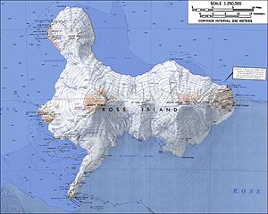
English: Topographic map of Ross Island, Antarctica (1:250,000 scale) Français : Carte topographique de l'île de Ross, Antarctique (échelle 1:250 000) Türkçe: Ross Adası'nın topografik haritası, Antarktika (Ölçek 1:250 000) |
| Datum | not specified |
| Izvor | USGS Atlas of Antarctic Research |
| Autor | USGS |
| Ostale verzije |
|


|
|
This file has been superseded by Ross Island Map USGS 250k.png. It is recommended to use the other file. Please note that deleting superseded images requires consent. Reason to use the other file: "higher resolution and rendered in PNG"
|
|
Licenciranje
This image is in the public domain in the United States because it only contains materials that originally came from the United States Geological Survey, an agency of the United States Department of the Interior. For more information, see the official USGS copyright policy.
|
Historija datoteke
Kliknite na datum/vrijeme da vidite verziju datoteke iz tog vremena.
| Datum/vrijeme | Smanjeni pregled | Dimenzije | Korisnik | Komentar | |
|---|---|---|---|---|---|
| trenutno | 02:30, 15 januar 2005 | | 1.000 × 800 (166 KB) | GarciaB~commonswiki | Topographic map of Ross Island (1:250,000 scale) |
Upotreba datoteke
Sljedeća stranica koristi ovu datoteku:
Globalna upotreba datoteke
Sljedeći wikiji koriste ovu datoteku:
- Upotreba na ar.wikipedia.org
- Upotreba na ast.wikipedia.org
- Upotreba na bg.wikipedia.org
- Upotreba na ca.wikipedia.org
- Upotreba na cs.wikipedia.org
- Upotreba na da.wikipedia.org
- Upotreba na de.wikipedia.org
- Upotreba na el.wikipedia.org
- Upotreba na en.wikipedia.org
- Upotreba na eo.wikipedia.org
- Upotreba na es.wikipedia.org
- Upotreba na et.wikipedia.org
- Upotreba na fa.wikipedia.org
- Upotreba na fi.wikipedia.org
- Upotreba na fr.wikipedia.org
- Upotreba na he.wikipedia.org
Pogledajte globalne upotrebe ove datoteke.