
Datoteka:SaltGlaciers ZagrosMtns 20010810.jpg
Veličina ovog prikaza: 800 × 509 piksela. Ostale rezolucije: 320 × 204 piksela | 640 × 407 piksela | 1.149 × 731 piksela.
Izvorna datoteka (1.149 × 731 piksela, veličina datoteke: 231 KB, MIME tip: image/jpeg)
| Ova datoteka je s Wikimedia Commonsa. Opis s njene stranice opisa datoteke prikazan je ispod. Commons je skladište slobodnih medija i datoteka za sve projekte fondacije Wikimedia. Možete i Vi pomoći. |
Sažetak
| Object location | | View this and other nearby images on: OpenStreetMap |
|---|
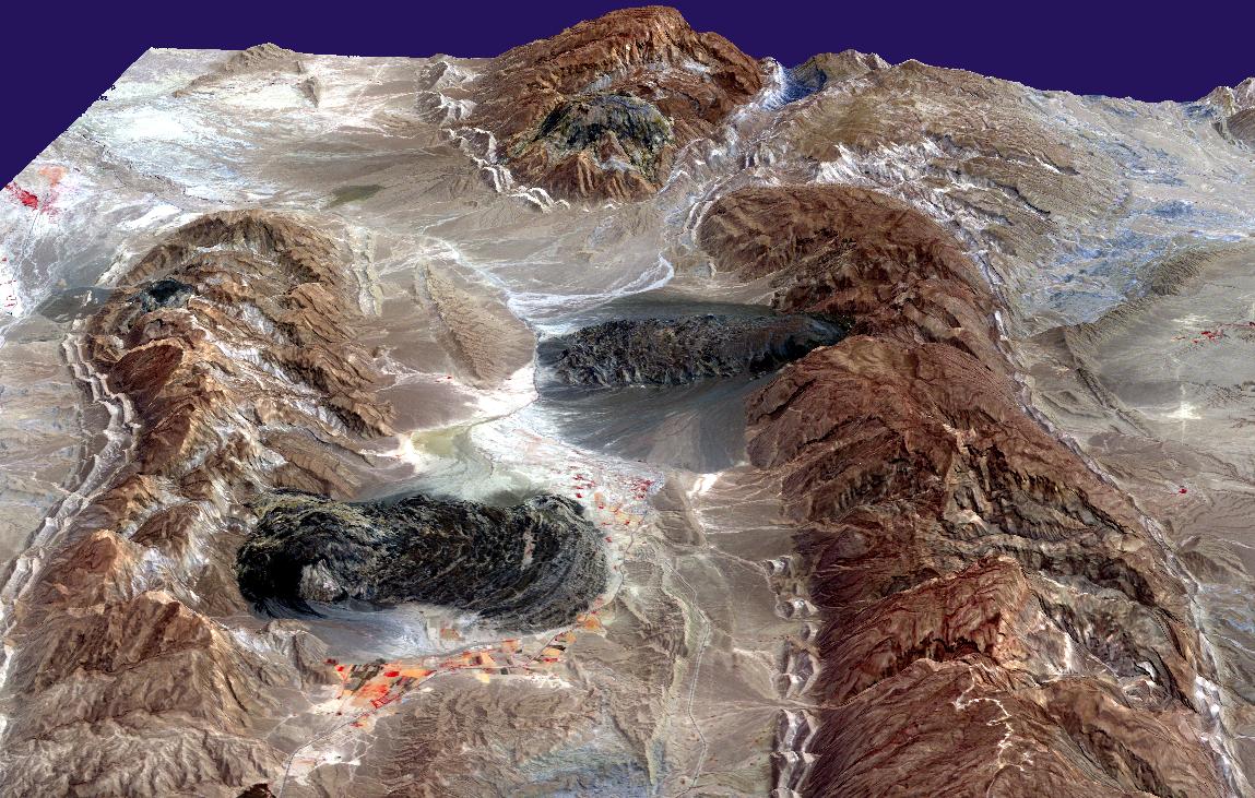
| Opis | Satellite imagery of salt domes and salt glaciers, visible as darkish irregular patches, Zagros Mountains, southern Iran, near Karmowstaj. Gravity has caused the salt to flow like glaciers into adjacent valleys. The resulting tongue-shaped bodies are more than 5 kilometers long, with repeating bow-shaped ridges separated by crevasse-like gullies and with steep sides and fronts. The darker tones are due to clays brought up with the salt, as well as the probable accumulation of airborne dust. This Aster perspective view was created by draping a band 3-2-1 (RGB) image over an ASTER-derived Digital Elevation Model (2x vertical exaggeration). |
| Datum | |
| Izvor | http://earthobservatory.nasa.gov/IOTD/view.php?id=4168 |
| Autor | NASA/GSFC/MITI/ERSDAC/JAROS, and U.S./Japan ASTER Science Team |
| Dopuštenje (Naknadno korištenje ove datoteke) |
US government, public domain |
Licenciranje
| This file is in the public domain in the United States because it was solely created by NASA. NASA copyright policy states that "NASA material is not protected by copyright unless noted". (See Template:PD-USGov, NASA copyright policy page or JPL Image Use Policy.) | ||
 |
Warnings:
|
Historija datoteke
Kliknite na datum/vrijeme da vidite verziju datoteke iz tog vremena.
| Datum/vrijeme | Smanjeni pregled | Dimenzije | Korisnik | Komentar | |
|---|---|---|---|---|---|
| trenutno | 18:49, 27 april 2006 | | 1.149 × 731 (231 KB) | Holly Cheng | {{Information | Description=Satellite imagery of w:salt domes and w:salt glaciers in the w:Zagros Mountains of southern Iran. This w:ASTER perspective view was created by draping a band 3-2-1 (RGB) image over an ASTER-derived Digital Eleva |
Upotreba datoteke
Sljedeća stranica koristi ovu datoteku:
Globalna upotreba datoteke
Sljedeći wikiji koriste ovu datoteku:
- Upotreba na ar.wikipedia.org
- Upotreba na ast.wikipedia.org
- Upotreba na ca.wikipedia.org
- Upotreba na cs.wikipedia.org
- Upotreba na de.wikipedia.org
- Upotreba na en.wikipedia.org
- Upotreba na es.wikipedia.org
- Upotreba na fa.wikipedia.org
- Upotreba na fr.wikipedia.org
- Upotreba na hr.wikipedia.org
- Upotreba na it.wikipedia.org
- Upotreba na ja.wikipedia.org
- Upotreba na ru.wikipedia.org
- Upotreba na sh.wikipedia.org
- Upotreba na sr.wikipedia.org
- Upotreba na uk.wikipedia.org