
Datoteka:SevenYearsWar.png

Veličina ovog prikaza: 800 × 370 piksela. Ostale rezolucije: 320 × 148 piksela | 640 × 296 piksela | 1.357 × 628 piksela.
Izvorna datoteka (1.357 × 628 piksela, veličina datoteke: 41 KB, MIME tip: image/png)
| Ova datoteka je s Wikimedia Commonsa. Opis s njene stranice opisa datoteke prikazan je ispod. Commons je skladište slobodnih medija i datoteka za sve projekte fondacije Wikimedia. Možete i Vi pomoći. |

|
This military map image could be re-created using vector graphics as an SVG file. This has several advantages; see Commons:Media for cleanup for more information. If an SVG form of this image is available, please upload it and afterwards replace this template with
{{vector version available|new image name}}.
It is recommended to name the SVG file “SevenYearsWar.svg”—then the template Vector version available (or Vva) does not need the new image name parameter. |
Sažetak
| Opis |
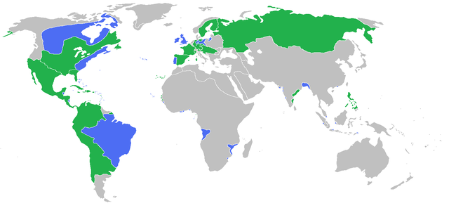
English: Locator map of the competing sides of the Seven Years War before outset of the war (mid-1750s). Blue: Great Britain, Portugal with more. Green: France, Spain with more. Great Britain, Prussia, Portugal, with allies
France, Spain, Austria, Russia, Sweden with allies Français : Carte montrant les forces en présence lors de la guerre de Sept Ans (milieu des années 1750).
Grande Bretagne, Prusse, Portugal, leurs alliés et dépendances
France, Espagne, Autriche, Russie, Suède, leurs alliés et dépendances (Partially based on Atlas of World History (2007) - There was also a treaty in 1783, Imperialism and Revolutions, map) |
| Datum | |
| Izvor | Vlastito djelo |
| Autor | Gabagool |
Licenciranje
Ja, vlasnik autorskog prava ovog djela, ovdje ga objavljujem pod sljedećom licencom:
Ova datoteka je licencirana pod Creative Commons Attribution 3.0 neportiranom licencom.
- Slobodni ste:
- da dijelite – da kopirate, distributirate i prenosite djelo
- da remiksate – da prilagodite djelo
- Pod sljedećim uslovima:
- pripisivanje – Morate pripisati odgovarajuće autorske zasluge, osigurati link ka licenci i naznačiti jesu li napravljene izmjene. To možete uraditi na bilo koji razumni način, ali ne tako da se sugerira da davalac licence odobrava Vas ili Vašu upotrebu njegovog djela.
Historija datoteke
Kliknite na datum/vrijeme da vidite verziju datoteke iz tog vremena.
| Datum/vrijeme | Smanjeni pregled | Dimenzije | Korisnik | Komentar | |
|---|---|---|---|---|---|
| trenutno | 17:54, 23 juni 2009 | | 1.357 × 628 (41 KB) | Gabagool | corrected India more appropriatly |
| 15:59, 11 juni 2009 |  | 1.357 × 628 (41 KB) | Gabagool | some fixes | |
| 13:16, 11 juni 2009 |  | 1.357 × 628 (41 KB) | Gabagool | more details in Germany | |
| 00:20, 7 juni 2009 |  | 1.357 × 628 (41 KB) | Gabagool | {{Information |Description={{en|1=Locator map of the competing sides of the Seven Years War before outset of the war (early 1750s).<br> Blue: Great Britain, Portugal with more. Green: France, Spain with more. Light green: French largest expansion in India |
Upotreba datoteke
Sljedeća stranica koristi ovu datoteku:
Globalna upotreba datoteke
Sljedeći wikiji koriste ovu datoteku:
- Upotreba na af.wikipedia.org
- Upotreba na als.wikipedia.org
- Upotreba na an.wikipedia.org
- Upotreba na ar.wikipedia.org
- Upotreba na arz.wikipedia.org
- Upotreba na ast.wikipedia.org
- Upotreba na az.wikipedia.org
- Upotreba na ba.wikipedia.org
- Upotreba na bg.wikipedia.org
- Upotreba na bn.wikipedia.org
- Upotreba na br.wikipedia.org
- Upotreba na ca.wikipedia.org
- Upotreba na cs.wikipedia.org
- Upotreba na da.wikipedia.org
- Upotreba na de.wikipedia.org
- Upotreba na dsb.wikipedia.org
- Upotreba na en.wikipedia.org
- Upotreba na eo.wikipedia.org
- Upotreba na es.wikipedia.org
- Upotreba na fa.wikipedia.org
- Upotreba na fi.wikipedia.org
- Upotreba na fr.wikipedia.org
- Upotreba na ga.wikipedia.org
- Upotreba na he.wikipedia.org
- Upotreba na hi.wikipedia.org
- Upotreba na hsb.wikipedia.org
- Upotreba na is.wikipedia.org
- Upotreba na it.wikipedia.org
- Upotreba na ja.wikipedia.org
- Upotreba na ko.wikipedia.org
- Upotreba na lt.wikipedia.org
- Upotreba na lv.wikipedia.org
- Upotreba na ml.wikipedia.org
Pogledajte globalne upotrebe ove datoteke.