
Datoteka:Strait of Gibraltar 5.53940W 35.97279N.jpg

Veličina ovog prikaza: 800 × 599 piksela. Ostale rezolucije: 320 × 240 piksela | 640 × 479 piksela | 1.024 × 766 piksela | 1.280 × 958 piksela.
Izvorna datoteka (1.280 × 958 piksela, veličina datoteke: 178 KB, MIME tip: image/jpeg)
| Ova datoteka je s Wikimedia Commonsa. Opis s njene stranice opisa datoteke prikazan je ispod. Commons je skladište slobodnih medija i datoteka za sve projekte fondacije Wikimedia. Možete i Vi pomoći. |
Sažetak
| Opis |
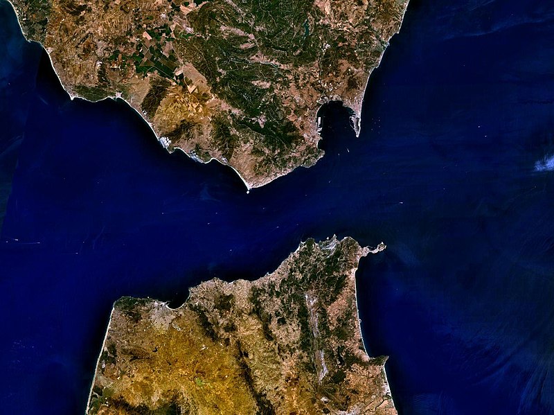
English: The Strait of Gibraltar |
| Datum | 15 maj 2005 (upload date) |
| Izvor | Satellite imagery taken by screenshot from NASA World Wind software |
| Autor | NASA |
| Object location | | View this and other nearby images on: OpenStreetMap |
|---|
Licenciranje
| This image is in the public domain because it is a screenshot from NASA’s globe software World Wind using a public domain layer, such as Blue Marble, MODIS, Landsat, SRTM, USGS or GLOBE.
|
 |
| Annotations | This image is annotated: View the annotations at Commons |
Historija datoteke
Kliknite na datum/vrijeme da vidite verziju datoteke iz tog vremena.
| Datum/vrijeme | Smanjeni pregled | Dimenzije | Korisnik | Komentar | |
|---|---|---|---|---|---|
| trenutno | 17:32, 15 maj 2005 | | 1.280 × 958 (178 KB) | Rex | NASA World Wind screenshot. {{PD-USGov-NASA}} Category:Seas |
Upotreba datoteke
Sljedeće 2 stranice koriste ovu datoteku:
Globalna upotreba datoteke
Sljedeći wikiji koriste ovu datoteku:
- Upotreba na arz.wikipedia.org
- Upotreba na ast.wikipedia.org
- Upotreba na ban.wikipedia.org
- Upotreba na ba.wikipedia.org
- Upotreba na ceb.wikipedia.org
- Upotreba na cv.wikipedia.org
- Upotreba na de.wikipedia.org
- Upotreba na en.wikipedia.org
- Upotreba na en.wiktionary.org
- Upotreba na es.wikipedia.org
- Upotreba na eu.wikipedia.org
- Upotreba na fi.wikipedia.org
- Upotreba na fr.wikipedia.org
- Upotreba na fr.wikivoyage.org
- Upotreba na fr.wiktionary.org
- Upotreba na gl.wiktionary.org
- Upotreba na ia.wikipedia.org
- Upotreba na id.wikipedia.org
- Upotreba na id.wiktionary.org
- Upotreba na is.wikipedia.org
- Upotreba na it.wikipedia.org
- Upotreba na jv.wikipedia.org
- Upotreba na ko.wikipedia.org
- Upotreba na ky.wikipedia.org
- Upotreba na mg.wikipedia.org
- Upotreba na min.wikipedia.org
- Upotreba na ms.wikipedia.org
- Upotreba na nl.wikipedia.org
- Upotreba na pl.wiktionary.org
Pogledajte globalne upotrebe ove datoteke.