Datoteka:Syrian Civil War map (March 15 2013).svg

Sadržaj stranice nije podržan na drugim jezicima.
S Wikipedije, slobodne enciklopedije

Izvorna datoteka(SVG datoteka, nominalno 922 × 762 piksela, veličina datoteke: 18,22 MB)

Sažetak

Opis
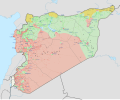
English: Detailed map of Syria showing the approximate frontlines during mid-March 2013; inspired by Ermanarich's work. All credit goes to Cedric Labrousse's work (https://twitter.com/syria_rebel_obs).


Controlled by the Syrian Arab Republic
 
Controlled by the Syrian Opposition
 
Controlled by the Democratic Union Party
 
The disputed frontline between the forces
 
Truce/ceasefire zones

In the respective colours:
Stable mixed control
Rural presence
Contested
Strategic hill
Oilfield/Gasfield
Military base or checkpoint
Airport/Air base (plane)
Heliport/Helicopter base
Major port or naval base
Border post
Dam

Industrial complex
Datum
Izvor Vlastito djelo
Autor Rr016
SVG genesis
InfoField
 
The source code of this large SVG is invalid due to 51 errors.
 
This oversized W3C-invalid icon was created with Inkscape.
 
 This icon uses embedded text that can be easily translated using a text editor.
This icon is a retouched picture, which means that it has been digitally altered from its original version. Modifications: Marks for the cities and towns as well as colour on the ground were added to show the situation in the Syrian Civil War during March 2013. The original can be viewed here: Syria location map3.svg. Modifications made by Rr016.

Licenciranje

Ja, vlasnik autorskog prava ovog djela, ovdje ga objavljujem pod sljedećom licencom:
w:bs:Creative Commons
pripisivanje dijeli pod istim uslovima
This file is licensed under the Creative Commons Attribution-Share Alike 4.0 International license.
Slobodni ste:
  • da dijelite – da kopirate, distributirate i prenosite djelo
  • da remiksate – da prilagodite djelo
Pod sljedećim uslovima:
  • pripisivanje – Morate pripisati odgovarajuće autorske zasluge, osigurati link ka licenci i naznačiti jesu li napravljene izmjene. To možete uraditi na bilo koji razumni način, ali ne tako da se sugerira da davalac licence odobrava Vas ili Vašu upotrebu njegovog djela.
  • dijeli pod istim uslovima – Ako mijenjate, transformišete ili nadograđujete ovaj materijal, morate ga objaviti i distribuirati samo pod istom ili sličnom licencom poput ove.

Captions

Add a one-line explanation of what this file represents
Syria amidst the civil war in 2013.

Items portrayed in this file

prikazuje

MIME type engleski

image/svg+xml

Historija datoteke

Kliknite na datum/vrijeme da vidite verziju datoteke iz tog vremena.

(najnovije | najstarije) Pogledaj (novije 10 | ) (10 | 20 | 50 | 100 | 250 | 500)
Datum/vrijemeSmanjeni pregledDimenzijeKorisnikKomentar
trenutno23:54, 30 august 2021Smanjeni pregled verzije na dan 23:54, 30 august 2021922 × 762 (18,22 MB)Rr016Corrections to Hama and Homs frontlines
17:12, 8 decembar 2020Smanjeni pregled verzije na dan 17:12, 8 decembar 2020922 × 762 (18,22 MB)Rr016Corrections here and there
21:52, 19 mart 2020Smanjeni pregled verzije na dan 21:52, 19 mart 2020922 × 762 (18,76 MB)Rr016Corrections to Damascus area
16:10, 2 mart 2020Smanjeni pregled verzije na dan 16:10, 2 mart 2020922 × 762 (18,76 MB)Rr016Corrections to Deir ez Zor province
22:04, 11 januar 2020Smanjeni pregled verzije na dan 22:04, 11 januar 2020922 × 762 (18,75 MB)Rr016More corrections to Daraa province
19:37, 24 decembar 2019Smanjeni pregled verzije na dan 19:37, 24 decembar 2019922 × 762 (18,75 MB)Rr016Changes to Daraa and Quneitra frontlines
15:15, 12 septembar 2019Smanjeni pregled verzije na dan 15:15, 12 septembar 2019922 × 762 (18,75 MB)Rr016Corrections made: 1) Dabaa airbase (Homs) was taken by rebels 18 April 2013 2) Zayta and Nazariyah (Homs) were always under SAA/Hezbollah control 3) Shirij (Hasakah) was seized by YPG mid-September 2013
20:06, 20 august 2019Smanjeni pregled verzije na dan 20:06, 20 august 2019922 × 762 (18,74 MB)Rr016Corrections made: 1) Khan Shaykhun (Idlib) was under siege until March 2014 2) Ayn Issa (Raqqa) was taken by rebels 30 March 2013 3) Tell Maaruf (Hasakah) was under YPG control since late February 2013 4) Thayyem Oil Field (Deir ez Zor) was under rebel control since late February 2013
21:25, 19 juli 2019Smanjeni pregled verzije na dan 21:25, 19 juli 2019922 × 762 (18,29 MB)Rr016Corrections made: 1) Jabal Turkman (Latakia) frontlines fixed 2) Qabtin & Junayd (Aleppo) were taken by rebels 14 March 2013 3) Sarrin (Aleppo) was not under YPG control yet
01:49, 22 juni 2019Smanjeni pregled verzije na dan 01:49, 22 juni 2019922 × 762 (18,29 MB)Rr016Corrections made: 1) Namer (Daraa) was taken by SAA in May 2013 2) Tall Rusayn (Hasakah) was taken by YPG in November 2013 3) Qara and an-Nabek (Damascus) were taken by rebels in May/June 2013
(najnovije | najstarije) Pogledaj (novije 10 | ) (10 | 20 | 50 | 100 | 250 | 500)

Sljedeća stranica koristi ovu datoteku:

Globalna upotreba datoteke

Sljedeći wikiji koriste ovu datoteku:

Metapodaci