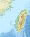
Datoteka:Taiwan relief location map.jpg

Sadržaj stranice nije podržan na drugim jezicima.
S Wikipedije, slobodne enciklopedije

Izvorna datoteka(1.016 × 1.222 piksela, veličina datoteke: 101 KB, MIME tip: image/jpeg)

Warning sign This file requires updating because: The earlier forms of this map did not extend a dotted-line around Dongyin, Lienchiang (Tungyin). The northern edge of this map ought to be moved up a little bit (in latitude) so that a dotted line encompassing Dongyin (Tungyin) can be clearly drawn and so that we can see a few of the islands north of Lienchiang County in Haidao Township, PRC. Example of a better map from The Economist: [1]. In doing so, you could add a timestamp to the file.
Please notify the uploader with {{subst:update-note|1=File:Taiwan relief location map.jpg|2=The earlier forms of this map did not extend a dotted-line around Dongyin, Lienchiang (Tungyin). The northern edge of this map ought to be moved up a little bit (in latitude) so that a dotted line encompassing Dongyin (Tungyin) can be clearly drawn and so that we can see a few of the islands north of Lienchiang County in Haidao Township, PRC. Example of a better map from The Economist: [2].}} ~~~~

Sažetak

Opis
English: Relief location map of Taiwan.
  • Projection: Equirectangular projection, strechted by 110.0%.
  • Geographic limits of the map:
  • N: 26.4° N
  • S: 21.7° N
  • W: 118.0° E
  • E: 122.3° E
  • GMT projection: -JX17.204266666666665cd/20.68512992248063cd
  • GMT region: -R118.0/21.7/122.3/26.4r
  • GMT region for grdcut: -R118.0/21.7/122.3/26.4r
  • Relief: SRTM30plus.
  • Made with Natural Earth. Free vector and raster map data @ naturalearthdata.com.
Datum
Izvor Vlastito djelo
Autor Uwe Dedering

Licenciranje

Ja, vlasnik autorskog prava ovog djela, ovdje ga objavljujem pod sljedećim licencama:
w:bs:Creative Commons
pripisivanje dijeli pod istim uslovima
Ova datoteka je licencirana pod Creative Commons Attribution-Share Alike 3.0 neportovanom, 2.5 generičkom, 2.0 generičkom i 1.0 generičkom licencom.
Slobodni ste:
  • da dijelite – da kopirate, distributirate i prenosite djelo
  • da remiksate – da prilagodite djelo
Pod sljedećim uslovima:
  • pripisivanje – Morate pripisati odgovarajuće autorske zasluge, osigurati link ka licenci i naznačiti jesu li napravljene izmjene. To možete uraditi na bilo koji razumni način, ali ne tako da se sugerira da davalac licence odobrava Vas ili Vašu upotrebu njegovog djela.
  • dijeli pod istim uslovima – Ako mijenjate, transformišete ili nadograđujete ovaj materijal, morate ga objaviti i distribuirati samo pod istom ili sličnom licencom poput ove.
GNU head Dozvoljeno je kopirati, distribuirati i/ili mijenjati ovaj članak pod uslovima navedenim u GNU licenci za slobodnu dokumentaciju, verzija 1.2 ili kasnijom verzijom izdatom od Free Software Foundation; bez nepromjenljivih dijelova, te bez sadržaja na naslovnoj i zadnjoj strani. Kopija licence se nalazi pod poglavljem GNU Free Documentation License.
Možete odabrati licencu po vašem izboru.

Captions

Add a one-line explanation of what this file represents

Items portrayed in this file

prikazuje

MIME type engleski

image/jpeg

Historija datoteke

Kliknite na datum/vrijeme da vidite verziju datoteke iz tog vremena.

Datum/vrijemeSmanjeni pregledDimenzijeKorisnikKomentar
trenutno16:01, 19 septembar 2019Smanjeni pregled verzije na dan 16:01, 19 septembar 20191.016 × 1.222 (101 KB)Geographyinitiativetemporary fix: extending the boundary out around Dongyin Township (as in China Fujian2 location map.svg and as in File:Nationalist China - administrative divisons. LOC 2007633622.jpg)
19:09, 3 august 2019Smanjeni pregled verzije na dan 19:09, 3 august 20191.016 × 1.222 (537 KB)NordNordWestborder corrections
03:51, 3 august 2019Smanjeni pregled verzije na dan 03:51, 3 august 20191.016 × 1.222 (96 KB)GeographyinitiativeProposed removal of three dashes (markers of the approximate PRC/ROC maritime boundary) which seemed to put Dadan Island, Erdan Island and Binlang Islet (檳榔嶼) outside the territory of Kinmen County, Taiwan/ROC. This is not the optimal form of the map, but is merely a quick removal of incorrect information. In the optimal situation, the line needs to be redrawn in the correct location, but I don't have the technical skill to produce such a map. (Basis: [http://ws.mac.gov.tw/001/Upload/OldFile/...
02:30, 3 august 2019Smanjeni pregled verzije na dan 02:30, 3 august 20191.016 × 1.222 (96 KB)GeographyinitiativeProposed removal of two dashes (markers of the approximate PRC/ROC maritime boundary) which seemed to put {{w|Dadan Island}} and {{w|Erdan Island}} outside the territory of {{w|Kinmen County}}, Taiwan/ROC.
19:22, 28 decembar 2010Smanjeni pregled verzije na dan 19:22, 28 decembar 20101.016 × 1.222 (452 KB)Uwe Dedering{{Information |Description={{en|1=Relief location map of Taiwan. * Projection: Equirectangular projection, strechted by 110.0%. * Geographic limits of the map: :* N: 26.4° N :* S: 21.7° N :* W: 118.0° E :* E: 122.3° E * GMT projection: -JX17.204266666

Sljedeća stranica koristi ovu datoteku:

Globalna upotreba datoteke

Sljedeći wikiji koriste ovu datoteku:

Pogledajte globalne upotrebe ove datoteke.

Metapodaci