Datoteka:Washington, D.C. locator map.svg
Sadržaj stranice nije podržan na drugim jezicima.
S Wikipedije, slobodne enciklopedije

Izvorna datoteka(SVG datoteka, nominalno 750 × 550 piksela, veličina datoteke: 160 KB)

Opis
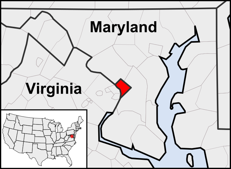
English: This is a map of the location of the District of Columbia showing the borders of states and counties around it.
Datum (UTC)
Izvor
Autor
Ostale verzije

Derivative works of this file:  United States geographical collation.svg All the below are of the states (and DC) only.
Blank US map.svg Map of states
Labelled US map.svg Map with state labels
USA_blank.svg Image with Hawaii and Alaska in full size
Original blank map of USA and Canada, That image with labels
Original with Hawaii at the natural distance, That original map with labels

File:DC locator map with state names w usmap.png and File:DC locator map with state names.jpg


This is a retouched picture, which means that it has been digitally altered from its original version. Modifications: Cropping to area around District of Columbia. The original can be viewed here: Blank USA, w territories.svg. Modifications made by Patrickneil.

w:bs:Creative Commons
pripisivanje dijeli pod istim uslovima
Ova datoteka je licencirana pod Creative Commons Attribution-Share Alike 3.0 neportiranom licencom.
Slobodni ste:
  • da dijelite – da kopirate, distributirate i prenosite djelo
  • da remiksate – da prilagodite djelo
Pod sljedećim uslovima:
  • pripisivanje – Morate pripisati odgovarajuće autorske zasluge, osigurati link ka licenci i naznačiti jesu li napravljene izmjene. To možete uraditi na bilo koji razumni način, ali ne tako da se sugerira da davalac licence odobrava Vas ili Vašu upotrebu njegovog djela.
  • dijeli pod istim uslovima – Ako mijenjate, transformišete ili nadograđujete ovaj materijal, morate ga objaviti i distribuirati samo pod istom ili sličnom licencom poput ove.

Originalni zapisnik postavljanja

This image is a derivative work of the following images:

  • File:USA_Counties.svg licensed with PD-USGov-DOC-Census
    • 2007-12-23T15:47:48Z Lokal Profil 555x352 (2124572 Bytes) Fixed state borders and fixed the two parts of Fulton County (Kentucky)
    • 2007-12-10T02:20:23Z Lokal Profil 555x352 (2136501 Bytes) Graphical and code cleanup
    • 2007-12-10T01:15:05Z Lokal Profil 792x612 (2135690 Bytes) First stab at a code cleanup
    • 2006-08-29T00:14:37Z Petr Dlouhý 792x612 (2844548 Bytes) Original file: [[:en:Image:USA CountiesSVG.zip]] This [[ZIP (file format)|ZIP]] file contains an [[SVG]] map of the [[United States]] showing the borders of states and counties in high detail. It was derived from [http://ww
  • File:Blank_USA,_w_territories.svg licensed with Cc-by-sa-3.0-migrated, GFDL
    • 2009-01-30T01:59:59Z Hoshie 959x593 (98189 Bytes) Reverted to version as of 23:58, 14 January 2009 - rv myself; DC can be seen clearly.
    • 2009-01-18T23:34:42Z Hoshie 959x593 (102341 Bytes) Put DC in an inset; fixed Tutuila (American Samoa)
    • 2009-01-14T23:58:05Z Lokal Profil 959x593 (98189 Bytes) Code cleanup and removed stroke from Guam and American Samoa
    • 2009-01-13T05:19:51Z Hoshie 959x593 (101361 Bytes) re did Guam and added American Samoa
    • 2007-12-02T16:08:45Z Lokal Profil 959x593 (88960 Bytes) {{Information |Description=A blank map of the United States including Puerto Rico, Guam, the United States Virgin Islands, and the Northern Mariana Islands. |Source=This version was made by [[:User:Lokal_Profil|Lokal_Profil]]

Uploaded with derivativeFX

Captions

Add a one-line explanation of what this file represents

Items portrayed in this file

prikazuje

Historija datoteke

Kliknite na datum/vrijeme da vidite verziju datoteke iz tog vremena.

(najnovije | najstarije) Pogledaj (novije 10 | ) (10 | 20 | 50 | 100 | 250 | 500)
Datum/vrijemeSmanjeni pregledDimenzijeKorisnikKomentar
trenutno05:23, 23 juli 2011Smanjeni pregled verzije na dan 05:23, 23 juli 2011750 × 550 (160 KB)PatrickneilReverted to version as of 03:04, 23 July 2011
05:21, 23 juli 2011Smanjeni pregled verzije na dan 05:21, 23 juli 2011750 × 550 (161 KB)PatrickneilReverted to version as of 03:14, 23 July 2011
05:20, 23 juli 2011Smanjeni pregled verzije na dan 05:20, 23 juli 2011750 × 550 (161 KB)Patrickneilframe
05:14, 23 juli 2011Smanjeni pregled verzije na dan 05:14, 23 juli 2011750 × 550 (161 KB)Patrickneilthicker frame
05:04, 23 juli 2011Smanjeni pregled verzije na dan 05:04, 23 juli 2011750 × 550 (160 KB)Patrickneilstraightening Maryland and Delaware borders
04:09, 15 august 2010Smanjeni pregled verzije na dan 04:09, 15 august 2010750 × 550 (202 KB)PatrickneilDelaware River again
03:51, 15 august 2010Smanjeni pregled verzije na dan 03:51, 15 august 2010750 × 550 (274 KB)PatrickneilDelaware River border
03:42, 15 august 2010Smanjeni pregled verzije na dan 03:42, 15 august 2010750 × 550 (273 KB)Patrickneilforgot border on Smith Island
03:34, 15 august 2010Smanjeni pregled verzije na dan 03:34, 15 august 2010750 × 550 (273 KB)Patrickneilcounty borders below state
03:32, 15 august 2010Smanjeni pregled verzije na dan 03:32, 15 august 2010750 × 550 (274 KB)Patrickneilchanges by request
(najnovije | najstarije) Pogledaj (novije 10 | ) (10 | 20 | 50 | 100 | 250 | 500)

Sljedeća stranica koristi ovu datoteku:

Globalna upotreba datoteke

Sljedeći wikiji koriste ovu datoteku:

Pogledajte globalne upotrebe ove datoteke.