
Datoteka:Wilparting Church 01.jpg

Veličina ovog prikaza: 800 × 506 piksela. Ostale rezolucije: 320 × 202 piksela | 640 × 405 piksela | 1.024 × 648 piksela | 1.280 × 809 piksela | 2.560 × 1.619 piksela | 4.031 × 2.549 piksela.
Izvorna datoteka (4.031 × 2.549 piksela, veličina datoteke: 8,2 MB, MIME tip: image/jpeg)
| Ova datoteka je s Wikimedia Commonsa. Opis s njene stranice opisa datoteke prikazan je ispod. Commons je skladište slobodnih medija i datoteka za sve projekte fondacije Wikimedia. Možete i Vi pomoći. |
Sažetak
| Opis |
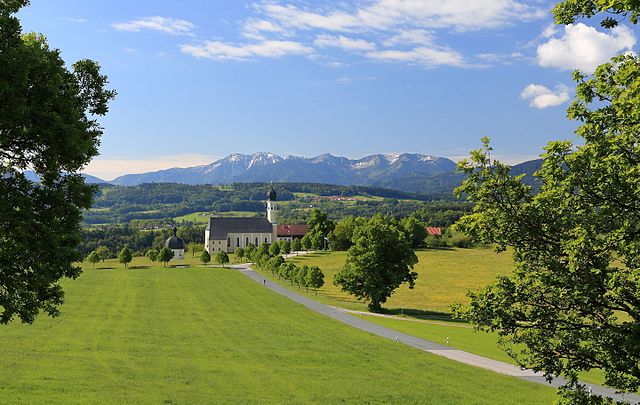
English: St. Marinus and Anian, Wilparting (Irschenberg), Bavaria, as seen from the north.
Español: Vista norte de la iglesia de St. Marinus und Anian en Wilparting (municipio de Irschenberg), Alta Baviera, Alemania.
Français : L'église Saints Marinus et Anianus à Wilparting (Irschenberg), en Bavière, Allemagne, vue du nord.
Polski: Widok od strony północnej na sanktuarium śś. Maryna i Aniana w Wilparting, części Irschenberg w Bawarii.
Português: Vista norte da igreja católica de St. Marinus und Anian em Wilparting, município de Irschenberg, Alta Baviera, Alemanha.
Български: Църквата „Св. Мариний и Аниан“ във Вилпартинг (Иршенберг), Бавария, както се вижда от север.
Deutsch: Die Wallfahrtskirche St. Marinus und Anian in Wilparting, einem Ortsteil von Irschenberg im Landkreis Miesbach, Oberbayern
Magyar: A Szent Marinus és Anian katolikus templom északi oldala (Wilparting, Irschenberg, Bajorország)
Македонски: Црквата „Св. Марин и Анијан“ во Иршенберг, Баварија, Германија.
|
|||||||||||||||||
| Datum | ||||||||||||||||||
| Izvor | Vlastito djelo | |||||||||||||||||
| Autor |
|
|||||||||||||||||

| Camera location | | View this and other nearby images on: OpenStreetMap |
|---|
Assessment
|
This image was selected as picture of the day on Wikimedia Commons for 26 May 2017. It was captioned as follows: English: The church St. Marinus und Anian, Wilparting (Irschenberg), Bavaria, as seen from the north. Other languages:
Deutsch: Die Wallfahrtskirche St. Marinus und Anian in Wilparting, einem Ortsteil von Irschenberg im Landkreis Miesbach, Oberbayern English: The church St. Marinus und Anian, Wilparting (Irschenberg), Bavaria, as seen from the north. Español: Vista norte de la iglesia de St. Marinus und Anian en Wilparting (municipio de Irschenberg), Alta Baviera, Alemania. Français : L'église Saints Marinus et Anianus à Wilparting (Irschenberg), en Bavière, Allemagne, vue du nord. Magyar: A Szent Marinus és Anian katolikus templom északi oldala (Wilparting, Irschenberg, Bajorország) Polski: Widok od strony północnej na sanktuarium śś. Maryna i Aniana w Wilparting, części Irschenberg w Bawarii. Português: Vista norte da igreja católica de St. Marinus und Anian em Wilparting, município de Irschenberg, Alta Baviera, Alemanha. Български: Църквата „Св. Мариний и Аниан“ във Вилпартинг (Иршенберг), Бавария, както се вижда от север. Македонски: Црквата „Св. Марин и Анијан“ во Иршенберг, Баварија, Германија. |
Licenciranje
Ja, vlasnik autorskog prava ovog djela, ovdje ga objavljujem pod sljedećom licencom:
This file is licensed under the Creative Commons Attribution-Share Alike 4.0 International license.
- Slobodni ste:
- da dijelite – da kopirate, distributirate i prenosite djelo
- da remiksate – da prilagodite djelo
- Pod sljedećim uslovima:
- pripisivanje – Morate pripisati odgovarajuće autorske zasluge, osigurati link ka licenci i naznačiti jesu li napravljene izmjene. To možete uraditi na bilo koji razumni način, ali ne tako da se sugerira da davalac licence odobrava Vas ili Vašu upotrebu njegovog djela.
- dijeli pod istim uslovima – Ako mijenjate, transformišete ili nadograđujete ovaj materijal, morate ga objaviti i distribuirati samo pod istom ili sličnom licencom poput ove.
Historija datoteke
Kliknite na datum/vrijeme da vidite verziju datoteke iz tog vremena.
| Datum/vrijeme | Smanjeni pregled | Dimenzije | Korisnik | Komentar | |
|---|---|---|---|---|---|
| trenutno | 17:13, 22 septembar 2016 | | 4.031 × 2.549 (8,2 MB) | Martin Falbisoner | repaired color profile |
| 21:20, 4 juni 2016 |  | 4.031 × 2.549 (7,93 MB) | Martin Falbisoner | more spots removed | |
| 15:45, 4 juni 2016 |  | 4.031 × 2.549 (7,9 MB) | Martin Falbisoner | spots removed | |
| 08:15, 30 maj 2016 |  | 4.031 × 2.549 (7,83 MB) | Martin Falbisoner | User created page with UploadWizard |
Upotreba datoteke
Nema stranica koje koriste ovu datoteku.
Globalna upotreba datoteke
Sljedeći wikiji koriste ovu datoteku:
- Upotreba na av.wikipedia.org
- Upotreba na be-tarask.wikipedia.org
- Upotreba na crh.wikipedia.org
- Upotreba na cv.wikipedia.org
- Upotreba na de.wikipedia.org
- Upotreba na de.wikivoyage.org
- Upotreba na en.wikipedia.org
- Upotreba na fy.wikipedia.org
- Upotreba na hu.wikipedia.org
- Upotreba na hy.wikipedia.org
- Upotreba na it.wiktionary.org
- Upotreba na ka.wikipedia.org
- Upotreba na ko.wikipedia.org
- Upotreba na krc.wikipedia.org
- Upotreba na lbe.wikipedia.org
- Upotreba na lez.wikipedia.org
- Upotreba na mdf.wikipedia.org
- Upotreba na mhr.wikipedia.org
- Upotreba na mk.wikipedia.org
- Upotreba na os.wikipedia.org
- Upotreba na pt.wikipedia.org
- Upotreba na ru.wikipedia.org
- Upotreba na ru.wikinews.org
- Upotreba na sah.wikipedia.org
- Upotreba na sh.wikipedia.org
- Upotreba na sq.wikipedia.org
- Upotreba na tyv.wikipedia.org
- Upotreba na udm.wikipedia.org
- Upotreba na uk.wikipedia.org
- Upotreba na vep.wikipedia.org
- Upotreba na vi.wikipedia.org
- Upotreba na xal.wikipedia.org
- Upotreba na zh.wikipedia.org