Datoteka:2008TC3-groundpath.png

Sadržaj stranice nije podržan na drugim jezicima.
S Wikipedije, slobodne enciklopedije

2008TC3-groundpath.png(329 × 352 piksela, veličina datoteke: 93 KB, MIME tip: image/png)

Sažetak

This geology image could be re-created using vector graphics as an SVG file. This has several advantages; see Commons:Media for cleanup for more information. If an SVG form of this image is available, please upload it and afterwards replace this template with {{vector version available|new image name}}.


It is recommended to name the SVG file “2008TC3-groundpath.svg”—then the template Vector version available (or Vva) does not need the new image name parameter.
Opis
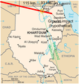
English: Ground track and probable explosion point in midair of the asteroid 2008 TC3 which entered earth's atmosphere and exploded over Sudan on 2008-10-06.

Original map CIA Factbook. Graphic overlay George William Herbert 2008-10-07. GFDL and CC-BY-3.0 dual licensed.

Ground track from Very near NEO Meteoroid (Mike Kretlow); infrasound track from [1] (Dr Peter Brown).
Datum
Izvor Own work modifications to US Government PD / CIA Factbook map of Sudan
Autor George William Herbert (graphic overlay) / US Government (original map)

Licenciranje

Original map

Public domain
This image is in the public domain because it contains materials that originally came from the United States Central Intelligence Agency's World Factbook.

Bahasa Indonesia  čeština  Deutsch  eesti  English  español  Esperanto  français  galego  hrvatski  italiano  Nederlands  norsk nynorsk  polski  português  sicilianu  slovenščina  suomi  Türkçe  Zazaki  беларуская (тарашкевіца)  македонски  русский  српски / srpski  українська  ქართული  বাংলা  தமிழ்  മലയാളം  한국어  日本語  中文  中文(简体)  中文(繁體)  العربية  +/−

Graphic overlay

GNU head Dozvoljeno je kopirati, distribuirati i/ili mijenjati ovaj članak pod uslovima navedenim u GNU licenci za slobodnu dokumentaciju, verzija 1.2 ili kasnijom verzijom izdatom od Free Software Foundation; bez nepromjenljivih dijelova, te bez sadržaja na naslovnoj i zadnjoj strani. Kopija licence se nalazi pod poglavljem GNU Free Documentation License.
w:bs:Creative Commons
pripisivanje
Ova datoteka je licencirana pod Creative Commons Attribution 3.0 neportiranom licencom.
Slobodni ste:
  • da dijelite – da kopirate, distributirate i prenosite djelo
  • da remiksate – da prilagodite djelo
Pod sljedećim uslovima:
  • pripisivanje – Morate pripisati odgovarajuće autorske zasluge, osigurati link ka licenci i naznačiti jesu li napravljene izmjene. To možete uraditi na bilo koji razumni način, ali ne tako da se sugerira da davalac licence odobrava Vas ili Vašu upotrebu njegovog djela.

Captions

Add a one-line explanation of what this file represents

Items portrayed in this file

prikazuje

media type engleski

image/png

checksum engleski

de14cc3657e4edaa5e89307c6c1102a6f5645b00

data size engleski

94.777 Bajt

352 piksel

329 piksel

Historija datoteke

Kliknite na datum/vrijeme da vidite verziju datoteke iz tog vremena.

Datum/vrijemeSmanjeni pregledDimenzijeKorisnikKomentar
trenutno03:40, 8 oktobar 2008Smanjeni pregled verzije na dan 03:40, 8 oktobar 2008329 × 352 (93 KB)Georgewilliamherbert{{Information |Description={{en|1=Ground track and probable explosion point in midair of the asteroid 2008 TC3 which entered earth's atmosphere and exploded over Sudan on 2008-10-06. Original map CIA Factbook. Graphic overlay George William Herbert 2008

Sljedeća stranica koristi ovu datoteku:

Globalna upotreba datoteke

Sljedeći wikiji koriste ovu datoteku: