
Datoteka:Bosnie et Sandjak 1904.svg

Veličina ovog PNG pregleda za ovu SVG datoteku: 657 × 600 piksela. Ostale rezolucije: 263 × 240 piksela | 526 × 480 piksela | 841 × 768 piksela | 1.122 × 1.024 piksela | 2.243 × 2.048 piksela | 2.000 × 1.826 piksela.
Izvorna datoteka (SVG datoteka, nominalno 2.000 × 1.826 piksela, veličina datoteke: 139 KB)
| Ova datoteka je s Wikimedia Commonsa. Opis s njene stranice opisa datoteke prikazan je ispod. Commons je skladište slobodnih medija i datoteka za sve projekte fondacije Wikimedia. Možete i Vi pomoći. |
Sažetak
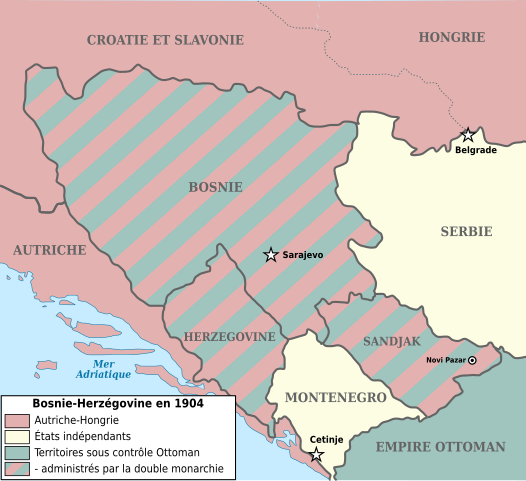
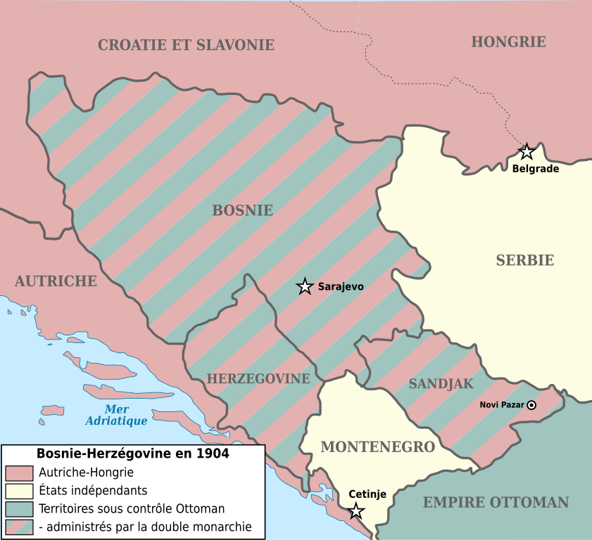
| Opis | Map showing Bosnia-Herzegovina and the Sanjak of Novibazar (1904). |
| Datum | (UTC) |
| Izvor | |
| Autor |
|
| Ostale verzije |
Derivative works of this file: |
| This is a retouched picture, which means that it has been digitally altered from its original version. The original can be viewed here: Bosnia-Herzegovina and Sanjak of Novibazar.JPG:
|

|
Dozvoljeno je kopirati, distribuirati i/ili mijenjati ovaj članak pod uslovima navedenim u GNU licenci za slobodnu dokumentaciju, verzija 1.2 ili kasnijom verzijom izdatom od Free Software Foundation; bez nepromjenljivih dijelova, te bez sadržaja na naslovnoj i zadnjoj strani. Kopija licence se nalazi pod poglavljem GNU Free Documentation License. |
| Ova datoteka je licencirana pod Creative Commons Attribution-Share Alike 3.0 neportiranom licencom. | ||
| ||
| Ova oznaka licence je dodana na ovu datoteku kao dio GFDL ažuriranja licence. |
Originalni zapisnik postavljanja
This image is a derivative work of the following images:
- Image:Bosnia-Herzegovina_and_Sanjak_of_Novibazar.JPG licensed with PD-US
- 2008-07-29T10:34:31Z Rcbutcher 5696x5200 (17763428 Bytes) {{Information |Description=Map showing Bosnia-Herzegovina and the Sanjak of Novibazar. |Source=The Century Dictionary and Cyclopedia, Vol X, Map No. 89, Copyright 1897 and 1902; Cyclopedia itself, Copyright 1889, 1890, 1891..
Uploaded with derivativeFX
Historija datoteke
Kliknite na datum/vrijeme da vidite verziju datoteke iz tog vremena.
| Datum/vrijeme | Smanjeni pregled | Dimenzije | Korisnik | Komentar | |
|---|---|---|---|---|---|
| trenutno | 18:34, 1 januar 2018 | | 2.000 × 1.826 (139 KB) | Flappiefh | Police DejaVu uniformisée, frontières inter-états plus marquées, changement du titre en légende. |
| 17:25, 30 decembar 2017 |  | 2.000 × 1.826 (129 KB) | Flappiefh | Modification apportées à la demande du Conteur (https://fr.wikipedia.org/wiki/Utilisateur:Conteur-momentanement-indisponible) via l'Atelier Cartes. Au programme : légende refaite, frontières en gris, Dalmatie remplacée par Autriche, une frontière... | |
| 22:39, 2 maj 2013 |  | 2.000 × 1.826 (82 KB) | Fulvio314 | Removed black artifact (Inkscape issue) | |
| 16:31, 29 decembar 2012 |  | 2.000 × 1.826 (108 KB) | Ciaurlec | Moved Dynamic text to simple text | |
| 10:03, 30 maj 2009 |  | 2.000 × 1.826 (109 KB) | Le serbe | (ajoute légende des états "avant blanc"(Serbie, Monténégro) La Hongrie n'est pas l'Autriche-Hongrie mais juste la Hongrie. L'Albanie et la Macédoine ne sont pas, la Turquie. La Turquie n'existe pas à l'époque, on parle d'empire ottoman. ) | |
| 10:02, 30 maj 2009 |  | 2.000 × 1.826 (109 KB) | Le serbe | ajoute légende des états "avant blanc"(Serbie, Monténégro) La Hongrie n'est pas l'Autriche-Hongrie mais juste la Hongrie. L'Albanie et la Macédoine ne sont pas, la Turquie. La Turquie n'existe pas à l'époque, on parle d'empire ottoman. | |
| 13:59, 16 septembar 2008 |  | 2.000 × 1.826 (163 KB) | Tinodela | {{Information |Description= |Source= |Date= |Author= |Permission= |other_versions= }} | |
| 13:58, 16 septembar 2008 |  | 2.000 × 1.826 (87 KB) | Tinodela | {{Information |Description=Map showing Bosnia-Herzegovina and the Sanjak of Novibazar (1904). |Source=*Image:Bosnia-Herzegovina_and_Sanjak_of_Novibazar.JPG |Date=2008-09-16 11:57 (UTC) |Author=*derivative work: ~~~ *[[:Image:Bosnia-Herzegovina_and_S |
Upotreba datoteke
Nema stranica koje koriste ovu datoteku.
Globalna upotreba datoteke
Sljedeći wikiji koriste ovu datoteku:
- Upotreba na el.wikipedia.org
- Upotreba na fi.wikipedia.org
- Upotreba na fr.wikipedia.org