
Datoteka:Bronx Highlight New York City Map Julius Schorzman.png
Veličina ovog prikaza: 616 × 600 piksela. Ostale rezolucije: 247 × 240 piksela | 493 × 480 piksela | 789 × 768 piksela | 1.052 × 1.024 piksela | 2.104 × 2.048 piksela | 2.652 × 2.582 piksela.
Izvorna datoteka (2.652 × 2.582 piksela, veličina datoteke: 4,67 MB, MIME tip: image/png)
| Ova datoteka je s Wikimedia Commonsa. Opis s njene stranice opisa datoteke prikazan je ispod. Commons je skladište slobodnih medija i datoteka za sve projekte fondacije Wikimedia. Možete i Vi pomoći. |
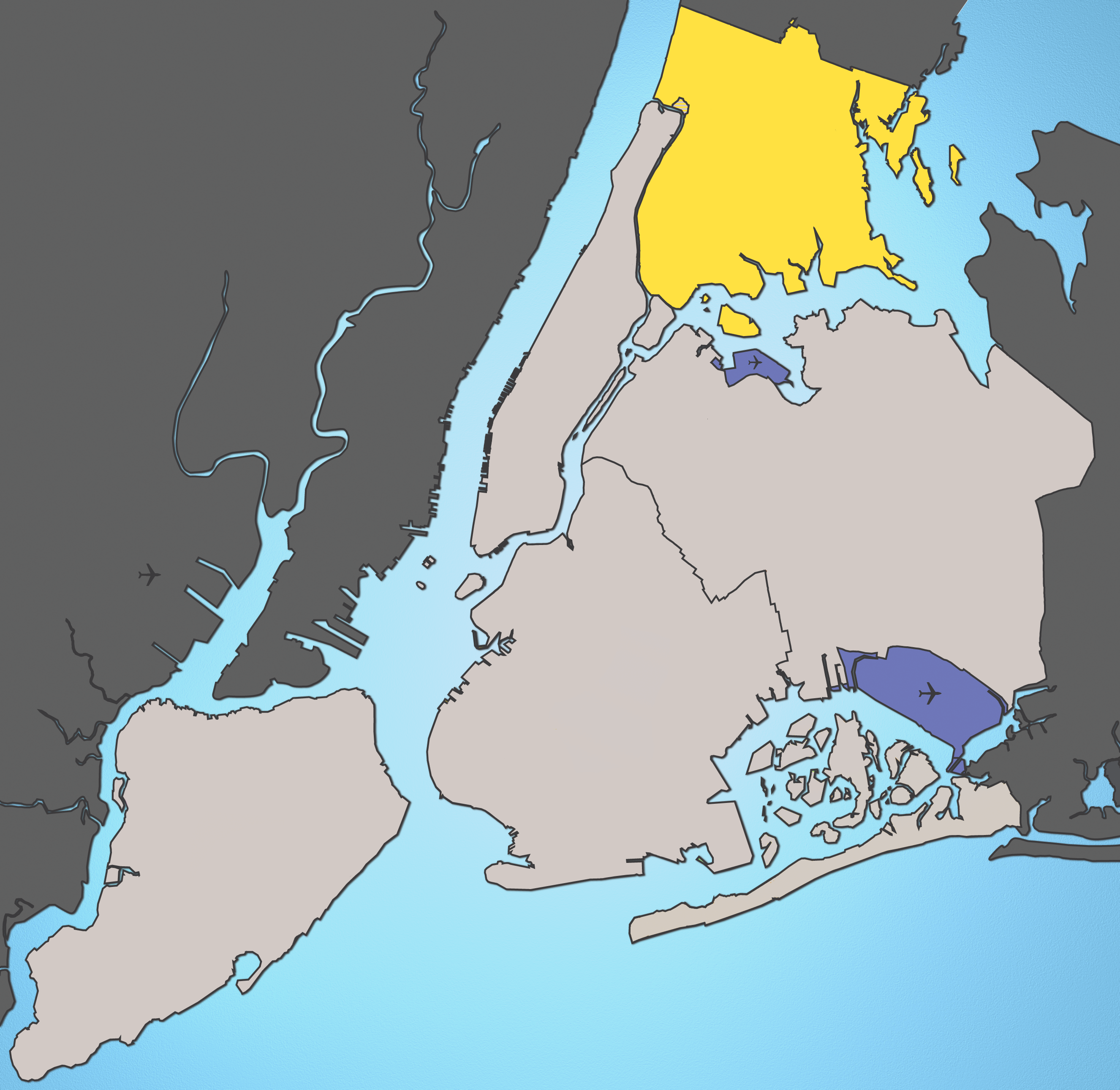
A map of New York City with the Bronx highlighted.

|
This map image could be re-created using vector graphics as an SVG file. This has several advantages; see Commons:Media for cleanup for more information. If an SVG form of this image is available, please upload it and afterwards replace this template with
{{vector version available|new image name}}.
It is recommended to name the SVG file “Bronx Highlight New York City Map Julius Schorzman.svg”—then the template Vector version available (or Vva) does not need the new image name parameter. |
Notes:
- Marble Hill is shown as part Manhattan, part Bronx. See Wikipedia:Marble Hill, Manhattan, New York for more information.
- Several islands (such as Rikers Island) are highlighted since they are governmentally a part of the Bronx
Source: I created this image using various maps and images.
Attribution: Julius Schorzman
Ova datoteka je licencirana pod Creative Commons Attribution-Share Alike 2.5 generičkom licencom.
- Slobodni ste:
- da dijelite – da kopirate, distributirate i prenosite djelo
- da remiksate – da prilagodite djelo
- Pod sljedećim uslovima:
- pripisivanje – Morate pripisati odgovarajuće autorske zasluge, osigurati link ka licenci i naznačiti jesu li napravljene izmjene. To možete uraditi na bilo koji razumni način, ali ne tako da se sugerira da davalac licence odobrava Vas ili Vašu upotrebu njegovog djela.
- dijeli pod istim uslovima – Ako mijenjate, transformišete ili nadograđujete ovaj materijal, morate ga objaviti i distribuirati samo pod istom ili sličnom licencom poput ove.
\
Historija datoteke
Kliknite na datum/vrijeme da vidite verziju datoteke iz tog vremena.
| Datum/vrijeme | Smanjeni pregled | Dimenzije | Korisnik | Komentar | |
|---|---|---|---|---|---|
| trenutno | 04:01, 19 august 2005 | | 2.652 × 2.582 (4,67 MB) | Quasipalm | A map of New York City with the Bronx highlighted. Notes: # '''Marble Hill''' is shown as part Manhattan, part Bronx. See wiki:Marble Hill for more information. # Several islands (such as '''Rikers Island''') are highlighted since they are governmen |
Upotreba datoteke
Sljedeća stranica koristi ovu datoteku:
Globalna upotreba datoteke
Sljedeći wikiji koriste ovu datoteku:
- Upotreba na bg.wikipedia.org
- Upotreba na de.wikipedia.org
- Upotreba na en.wikipedia.org
- Upotreba na en.wikinews.org
- Upotreba na fa.wikipedia.org
- Upotreba na frr.wikipedia.org
- Upotreba na fr.wikipedia.org
- Upotreba na fr.wikinews.org
- Upotreba na fr.wiktionary.org
- Upotreba na fy.wikipedia.org
- Upotreba na he.wikipedia.org
- Upotreba na hr.wikipedia.org
- Upotreba na hu.wikipedia.org
- Upotreba na is.wikipedia.org
- Upotreba na ja.wikipedia.org
- Upotreba na ka.wikipedia.org
- Upotreba na ko.wikipedia.org
- Upotreba na lt.wikipedia.org
- Upotreba na lv.wikipedia.org
- Upotreba na mk.wikipedia.org
- Upotreba na mr.wikipedia.org
- Upotreba na pl.wikipedia.org
- Upotreba na pt.wikipedia.org
- Upotreba na ru.wikipedia.org
- Upotreba na sh.wikipedia.org
- Upotreba na sk.wikipedia.org
- Upotreba na sr.wikipedia.org
- Upotreba na sw.wikipedia.org
- Upotreba na th.wikipedia.org
- Upotreba na tl.wikipedia.org
- Upotreba na uk.wikipedia.org
- Upotreba na xmf.wikipedia.org
- Upotreba na zh-min-nan.wikipedia.org