
Datoteka:Crimean Khanate 1600.gif
Veća rezolucija nije dostupna.
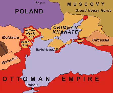
Crimean_Khanate_1600.gif (447 × 368 piksela, veličina datoteke: 23 KB, MIME tip: image/gif)
| Ova datoteka je s Wikimedia Commonsa. Opis s njene stranice opisa datoteke prikazan je ispod. Commons je skladište slobodnih medija i datoteka za sve projekte fondacije Wikimedia. Možete i Vi pomoći. |
| Opis | original description: "Black Sea Region in 1600". No reference is given for the data shown in the map. |
| Datum | 13 February 2005 (uploaded to en-wiki as 1600.gif) |
| Izvor | Nepoznat |
| Autor | Oleksa Haiworonski |
| Ostale verzije | No labels, Turkish, Norwegian, Russian |

|
This historical map image could be re-created using vector graphics as an SVG file. This has several advantages; see Commons:Media for cleanup for more information. If an SVG form of this image is available, please upload it and afterwards replace this template with
{{vector version available|new image name}}.
It is recommended to name the SVG file “Crimean Khanate 1600.svg”—then the template Vector version available (or Vva) does not need the new image name parameter. |

|
The copyright holder of this work allows anyone to use it for any purpose including unrestricted redistribution, commercial use, and modification.
Usage notes:
|
Historija datoteke
Kliknite na datum/vrijeme da vidite verziju datoteke iz tog vremena.
| Datum/vrijeme | Smanjeni pregled | Dimenzije | Korisnik | Komentar | |
|---|---|---|---|---|---|
| trenutno | 20:07, 4 juli 2015 | | 447 × 368 (23 KB) | Spiridon Ion Cepleanu | Yedisan, Budzak & Kertch : ottoman territories with tatar autonomous settlements. |
| 17:56, 20 oktobar 2010 |  | 447 × 368 (26 KB) | Liandrei | Removed watermark and border | |
| 15:11, 5 maj 2008 |  | 450 × 371 (27 KB) | Kjetil r | Removing "Ulus of Gazi", I can't find any reference to this nation, it seems like this area was part of the Crimean Khanate | |
| 20:21, 22 januar 2006 |  | 450 × 371 (28 KB) | Hardscarf | Crimean Khanate around 1600 From [http://en.wikipedia.org/wiki/Image:1600.gif english wikipedia] by [http://en.wikipedia.org/wiki/User_talk:Oleksa Oleksa] Original discription: Black Sea Region in 1600 Definition licence: ''Created: Oleksa Haiworon |
Upotreba datoteke
Sljedeća stranica koristi ovu datoteku:
Globalna upotreba datoteke
Sljedeći wikiji koriste ovu datoteku:
- Upotreba na ar.wikipedia.org
- Upotreba na azb.wikipedia.org
- Upotreba na bn.wikipedia.org
- Upotreba na br.wikipedia.org
- Upotreba na ca.wikipedia.org
- Upotreba na ckb.wikipedia.org
- Upotreba na cs.wikipedia.org
- Upotreba na da.wikipedia.org
- Upotreba na de.wikipedia.org
- Upotreba na el.wikipedia.org
- Upotreba na en.wikipedia.org
- Upotreba na en.wiktionary.org
- Upotreba na eo.wikipedia.org
- Upotreba na es.wikipedia.org
- Upotreba na et.wikipedia.org
- Upotreba na eu.wikipedia.org
- Upotreba na fa.wikipedia.org
- Upotreba na fr.wikipedia.org
- Upotreba na gl.wikipedia.org
- Upotreba na hi.wikipedia.org
- Upotreba na hu.wikipedia.org
- Upotreba na incubator.wikimedia.org
Pogledajte globalne upotrebe ove datoteke.