
Datoteka:Desenberg Westansicht Panorama 2014.jpg

Izvorna datoteka (11.576 × 2.040 piksela, veličina datoteke: 9,23 MB, MIME tip: image/jpeg)
| Ova datoteka je s Wikimedia Commonsa. Opis s njene stranice opisa datoteke prikazan je ispod. Commons je skladište slobodnih medija i datoteka za sve projekte fondacije Wikimedia. Možete i Vi pomoći. |
Sažetak
| Opis |
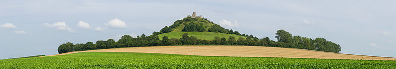
Deutsch: Panorama des Desenberg, Westansicht. Der Desenberg bei Daseburg, ein Inselberg und früherer Basaltvulkan, im nordrhein-westfälischen Kreis Höxter, ist die markanteste Erhebung der Warburger Börde. Auf der Spitze befindet sich die Burgruine Desenberg. Auf der Gipfelregion liegt ein eigenes Fauna-Flora-Habitat.
English: Panoramic view of Desenberg, western view. The hill Desenberg, a former volcano, near the village Daseburg is located in the area of Höxter in North Rhine-Westphalia. It is the most remarkable landmark of Warburger Börde flatlands. The area around the top has a very special flora and fauna due to its island position.
Português: Vista panorâmica do Desenberg, um vulcão extinto próximo a aldeia de Daseburg no distrito de Höxter, Renânia do Norte-Vestfália, Alemanha.
Български: Панорамен изглед от запад към хълма и някогашен вулкан Десенберг, Северен Райн-Вестфалия.
Bosanski: Panorama brda Desenberg, pogled sa zapada. Desenberg kod Daseburga je usamljeno brdo i ugašeni bazaltni vulkan u okrugu Höxter, Sjeverna Rajna-Vestfalija.
Español: Vista panorámica del antiguo volcán Desenberg cerca de la aldea Daseburg, Distrito de Höxter, Renania del Norte-Westfalia, Alemania.
Magyar: Desenberg, a Daseburg melletti vulkanikus tanúhegy panorámája nyugat felé nézve (Németország, Észak-Rajna-Vesztfália, Höxter kerület)
Italiano: Vista panoramica di Desenberg, un vulcano estinto vicino al villaggio di Daseburg nei pressi di Warburg in Germania.
한국어: 데젠베르크(Desenberg)의 서쪽 풍경. 예전에 화산이었던, 데젠부르크 마을 부근의 '데젠베르크' 언덕은 노르트라인베스트팔렌 주 획스터 영내에 위치한다. 이 언덕은 바르부르크 평원에서 가장 주목할 만한 랜드마크이다.
Nederlands: Panoramisch uitzicht op de Desenberg in de Duitse kreis Höxter. |
| Datum | |
| Izvor | Vlastito djelo |
| Autor | Tuxyso |
| Pripisivanje (required by the license) | Tuxyso / Wikimedia Commons / |
| Camera location | | View this and other nearby images on: OpenStreetMap |
|---|
|
This image was selected as picture of the day on Wikimedia Commons for 23 May 2015. It was captioned as follows: English: Panoramic view of Desenberg, western view. The hill Desenberg, a former volcano, near the village Daseburg is located in the area of Höxter in North Rhine-Westphalia. It is the most remarkable landmark of Warburger Börde flatlands. Other languages:
Bosanski: Panorama brda Desenberg, pogled sa zapada. Desenberg kod Daseburga je usamljeno brdo i ugašeni bazaltni vulkan u okrugu Höxter, Sjeverna Rajna-Vestfalija. Deutsch: Panorama des Desenberg, Westansicht. Der Desenberg bei Daseburg, ein Inselberg und früherer Basaltvulkan, im nordrhein-westfälischen Kreis Höxter, ist die markanteste Erhebung der Warburger Börde. English: Panoramic view of Desenberg, western view. The hill Desenberg, a former volcano, near the village Daseburg is located in the area of Höxter in North Rhine-Westphalia. It is the most remarkable landmark of Warburger Börde flatlands. Español: Vista panorámica del antiguo volcán Desenberg cerca de la aldea Daseburg, Distrito de Höxter, Renania del Norte-Westfalia, Alemania. Italiano: Vista panoramica di Desenberg, un vulcano estinto vicino al villaggio di Daseburg nei pressi di Warburg in Germania. Magyar: Desenberg, a Daseburg melletti vulkanikus tanúhegy panorámája nyugat felé nézve (Németország, Észak-Rajna-Vesztfália, Höxter kerület) Nederlands: Panoramisch uitzicht op de Desenberg in de Duitse kreis Höxter. Português: Vista panorâmica do Desenberg, um vulcão extinto próximo a aldeia de Daseburg no distrito de Höxter, Renânia do Norte-Vestfália, Alemanha. Български: Панорамен изглед от запад към хълма и някогашен вулкан Десенберг, Северен Райн-Вестфалия. 한국어: 데젠베르크(Desenberg)의 서쪽 풍경. 예전에 화산이었던, 데젠부르크 마을 부근의 '데젠베르크' 언덕은 노르트라인베스트팔렌 주 획스터 영내에 위치한다. 이 언덕은 바르부르크 평원에서 가장 주목할 만한 랜드마크이다. |
This image has been assessed using the Quality image guidelines and is considered a Quality image.
|
Licenciranje
- Slobodni ste:
- da dijelite – da kopirate, distributirate i prenosite djelo
- da remiksate – da prilagodite djelo
- Pod sljedećim uslovima:
- pripisivanje – Morate pripisati odgovarajuće autorske zasluge, osigurati link ka licenci i naznačiti jesu li napravljene izmjene. To možete uraditi na bilo koji razumni način, ali ne tako da se sugerira da davalac licence odobrava Vas ili Vašu upotrebu njegovog djela.
- dijeli pod istim uslovima – Ako mijenjate, transformišete ili nadograđujete ovaj materijal, morate ga objaviti i distribuirati samo pod istom ili sličnom licencom poput ove.
|
Dieses Foto ist vom Wikimedia Commons Nutzer Tuxyso. Achtung: Dieses Bild ist nicht gemeinfrei. Es ist zwar frei benutzbar aber gesetzlich geschützt. |
This photo was created by Wikimedia Commons user Tuxyso. Note: this image is not in the Public Domain. It is free to use but protected by law. |
||
|
|
Bitte benutzen sie nach Möglichkeit in der Bildbeschreibung: Tuxyso / Wikimedia Commons / CC-BY-SA-3.0 in unmittelbarer Nähe beim Bild oder an einer Stelle in ihrer Publikation, wo dies üblich ist. Dabei muß der Zusammenhang zwischen Bild und Urhebernennung gewahrt bleiben. |
I prefer the following credit: Tuxyso / Wikimedia Commons / CC-BY-SA-3.0 near to the photo or at a location that is common in your publication but preserving the association between image and credit. |
 |
|
Bitte lesen sie den Lizenztext gründlich, bevor sie das Bild nutzen! Wenn sie Fragen zu den Lizenzvereinbarungen haben oder mich auf eine interessante Nachnutzung hinweisen möchten, kontaktieren sie mich bitte per Mail: tuxyso@gmail.com. |
Please review the license requirements carefully before using this image. If you would like to clarify the license terms or inform me about a reuse of the image (which is always interesting for me), please contact me by email: tuxyso@gmail.com. |
||

Historija datoteke
Kliknite na datum/vrijeme da vidite verziju datoteke iz tog vremena.
| Datum/vrijeme | Smanjeni pregled | Dimenzije | Korisnik | Komentar | |
|---|---|---|---|---|---|
| trenutno | 16:33, 9 august 2014 | 11.576 × 2.040 (9,23 MB) | Tuxyso | slightly modified WB | |
| 23:55, 7 august 2014 | 11.576 × 2.040 (9,31 MB) | Tuxyso | work on the sky | ||
| 23:06, 6 august 2014 | 11.576 × 2.040 (9,08 MB) | Tuxyso | VicuñaUploader 1.20 |
Upotreba datoteke
Nema stranica koje koriste ovu datoteku.
Globalna upotreba datoteke
Sljedeći wikiji koriste ovu datoteku:
- Upotreba na be-tarask.wikipedia.org
- Upotreba na bn.wikipedia.org
- Upotreba na crh.wikipedia.org
- Upotreba na cv.wikipedia.org
- Upotreba na de.wikipedia.org
- Upotreba na hu.wikipedia.org
- Upotreba na is.wikipedia.org
- Upotreba na ka.wikipedia.org
- Upotreba na ko.wikipedia.org
- Upotreba na krc.wikipedia.org
- Upotreba na lbe.wikipedia.org
- Upotreba na mg.wikipedia.org
- Upotreba na os.wikipedia.org
- Upotreba na pt.wikipedia.org
- Upotreba na ru.wikipedia.org
- Upotreba na ru.wikinews.org
- Upotreba na sah.wikipedia.org
- Upotreba na tt.wikipedia.org
- Upotreba na uk.wikipedia.org
- Upotreba na vi.wikipedia.org
- Upotreba na zh.wikipedia.org