
Datoteka:Hammurabi's Babylonia Locator Map 1.svg

Veličina ovog PNG pregleda za ovu SVG datoteku: 671 × 600 piksela. Ostale rezolucije: 269 × 240 piksela | 537 × 480 piksela | 859 × 768 piksela | 1.146 × 1.024 piksela | 2.291 × 2.048 piksela | 744 × 665 piksela.
Izvorna datoteka (SVG datoteka, nominalno 744 × 665 piksela, veličina datoteke: 154 KB)
| Ova datoteka je s Wikimedia Commonsa. Opis s njene stranice opisa datoteke prikazan je ispod. Commons je skladište slobodnih medija i datoteka za sve projekte fondacije Wikimedia. Možete i Vi pomoći. |
Sažetak
| Opis |
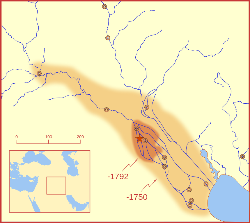
A locator map of Hammurabi's Babylonia, showing the Babylonian territory upon his ascension in 1792 BC and upon his death in 1750 BC. The river courses and coastline are those of that time period -- in general, they are not the modern rivers or coastlines. This is a Mercator projection, with north in its usual position. There is some question to what degree the cities of Nineveh, Tuttul, and Assur were under Babylonian authority. While in his introduction to his code of laws, Hammurabi claims lordship over these cities, Roaf does not include any of these in his map, upon which this map is based, and Chevalas states that "Assur and Nineveh were held for a very few years" (p. 155). Therefore, I have not included them as under Hammurabi's control in 1750 BC. |
| Datum | |
| Izvor | Vlastito djelo |
| Autor | MapMaster |
| Ostale verzije |
[]
|


Other versions
References
- Bjorklund, Oddvar; Holmboe, Haakon; Rohr, Anders (1970) Historical Atlas of the World, Barnes & Noble, NY, SBN: 389-00253-4.
- Chavalas, Mark W.; K. Lawson Younger (2003) Mesopotamia and the Bible, Continuum International Publishing Group, ISBN 978-0567082312.
- Hammond World Atlas Corporation (2007) Historical World Atlas, ISBN 9-780843-71391-6
- Roaf, M. (1990) Cultural Atlas of Mesopotamia and the ancient Near East, Oxford: Facts on File. (In general, the basis for the ancient river courses and ancient coastline).
- Van De Mieroop, Marc (2005). King Hammurabi of Babylon: A Biography. Blackwell Publishing. ISBN 1405126604
Licenciranje
Ja, vlasnik autorskog prava ovog djela, ovdje ga objavljujem pod sljedećim licencama:

|
Dozvoljeno je kopirati, distribuirati i/ili mijenjati ovaj članak pod uslovima navedenim u GNU licenci za slobodnu dokumentaciju, verzija 1.2 ili kasnijom verzijom izdatom od Free Software Foundation; bez nepromjenljivih dijelova, te bez sadržaja na naslovnoj i zadnjoj strani. Kopija licence se nalazi pod poglavljem GNU Free Documentation License. |
This file is licensed under the Creative Commons Attribution-Share Alike Attribution-Share Alike 4.0 International, 3.0 Unported, 2.5 Generic, 2.0 Generic and 1.0 Generic license.
- Slobodni ste:
- da dijelite – da kopirate, distributirate i prenosite djelo
- da remiksate – da prilagodite djelo
- Pod sljedećim uslovima:
- pripisivanje – Morate pripisati odgovarajuće autorske zasluge, osigurati link ka licenci i naznačiti jesu li napravljene izmjene. To možete uraditi na bilo koji razumni način, ali ne tako da se sugerira da davalac licence odobrava Vas ili Vašu upotrebu njegovog djela.
- dijeli pod istim uslovima – Ako mijenjate, transformišete ili nadograđujete ovaj materijal, morate ga objaviti i distribuirati samo pod istom ili sličnom licencom poput ove.
Možete odabrati licencu po vašem izboru.
Historija datoteke
Kliknite na datum/vrijeme da vidite verziju datoteke iz tog vremena.
| Datum/vrijeme | Smanjeni pregled | Dimenzije | Korisnik | Komentar | |
|---|---|---|---|---|---|
| trenutno | 05:26, 21 februar 2008 | | 744 × 665 (154 KB) | MapMaster | "blurred" the territory outlines |
| 01:22, 21 februar 2008 |  | 744 × 665 (149 KB) | MapMaster | Changes based on a review of ''Mesopotamia and the Bible'' | |
| 00:10, 21 februar 2008 |  | 744 × 665 (151 KB) | MapMaster | Minor edits | |
| 05:03, 19 februar 2008 |  | 744 × 665 (150 KB) | MapMaster | Once more, with feeling | |
| 04:09, 19 februar 2008 |  | 744 × 665 (151 KB) | MapMaster | earlier upload would not render | |
| 04:01, 19 februar 2008 |  | 332 × 292 (333 KB) | MapMaster | {{Information |Description=A locator map of Hammurabi's Babylonia, showing the Babylonian territory upon his ascension in 1792 BC and upon his death in 1750 BC. The river courses and coastline are those of that time period -- in general, they are not the |
Upotreba datoteke
Sljedeća stranica koristi ovu datoteku:
Globalna upotreba datoteke
Sljedeći wikiji koriste ovu datoteku:
- Upotreba na bg.wikipedia.org
- Upotreba na cs.wikipedia.org
- Upotreba na da.wikipedia.org
- Upotreba na el.wikipedia.org
- Upotreba na eo.wikipedia.org
- Upotreba na et.wikipedia.org
- Upotreba na fi.wikipedia.org
- Upotreba na fr.wikipedia.org
- Upotreba na gl.wikipedia.org
- Upotreba na he.wikipedia.org
- Upotreba na hr.wikipedia.org
- Upotreba na hu.wikipedia.org
- Upotreba na id.wikipedia.org
- Upotreba na it.wikipedia.org
- Upotreba na ja.wikipedia.org
- Upotreba na jv.wikipedia.org
- Upotreba na lt.wikipedia.org
- Upotreba na lv.wikipedia.org
- Upotreba na nl.wikipedia.org
- Upotreba na no.wikipedia.org
- Upotreba na pl.wikipedia.org
- Upotreba na pt.wikipedia.org
- Upotreba na ro.wikipedia.org
- Upotreba na ru.wikipedia.org
- Upotreba na sh.wikipedia.org
- Upotreba na sl.wikipedia.org
- Upotreba na sq.wikipedia.org
- Upotreba na sv.wikipedia.org
- Upotreba na sw.wikipedia.org
- Upotreba na tr.wikipedia.org