
Datoteka:ITER participants.png

Veličina ovog prikaza: 800 × 351 piksela. Ostale rezolucije: 320 × 140 piksela | 640 × 281 piksela | 1.425 × 625 piksela.
Izvorna datoteka (1.425 × 625 piksela, veličina datoteke: 37 KB, MIME tip: image/png)
| Ova datoteka je s Wikimedia Commonsa. Opis s njene stranice opisa datoteke prikazan je ispod. Commons je skladište slobodnih medija i datoteka za sve projekte fondacije Wikimedia. Možete i Vi pomoći. |

|
File:ITER participants.svg is a vector version of this file. It should be used in place of this PNG file when not inferior.
File:ITER participants.png → File:ITER participants.svg
For more information, see Help:SVG. |
 |
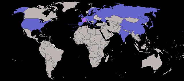
| Opis | Map of ITER participants - not showing overseas territories of the EU. (France and Cadarache -the host location - highlighted) |
| Datum | (UTC) |
| Izvor | |
| Autor |
|
| Ostale verzije |
|
| This is a retouched picture, which means that it has been digitally altered from its original version. The original can be viewed here: BlankMap-World-v7.png:
|
Ja, vlasnik autorskog prava ovog djela, ovdje ga objavljujem pod sljedećim licencama:
| Ova datoteka je licencirana pod Creative Commons Attribution-Share Alike 3.0 neportiranom licencom. | ||
| ||
| Ova oznaka licence je dodana na ovu datoteku kao dio GFDL ažuriranja licence. |

|
Dozvoljeno je kopirati, distribuirati i/ili mijenjati ovaj članak pod uslovima navedenim u GNU licenci za slobodnu dokumentaciju, verzija 1.2 ili kasnijom verzijom izdatom od Free Software Foundation; bez nepromjenljivih dijelova, te bez sadržaja na naslovnoj i zadnjoj strani. Kopija licence se nalazi pod poglavljem GNU Free Documentation License. |
Možete odabrati licencu po vašem izboru.
Originalni zapisnik postavljanja
This image is a derivative work of the following images:
- File:BlankMap-World-v7.png licensed with Cc-by-sa-3.0-migrated, GFDL
- 2010-01-16T07:36:16Z Happenstance 1425x625 (27705 Bytes) fx
- 2010-01-16T07:34:59Z Happenstance 1425x625 (27625 Bytes) darker colour for easier editing in Photoshop (so it doesn't default to grey-scale)
- 2008-07-31T14:49:14Z Avala 1425x625 (49260 Bytes)
- 2008-07-07T08:09:15Z Eynar 1425x625 (49297 Bytes) Updated according to [[:Image:BlankMap-World-v7-Borders.png]]: Fixed connecting pixel between Argentina and Chile. Added Canary Islands, Madeira and Azores (Canary Islands have a total area of 7447 km2, so I put their shape i
- 2008-03-22T21:59:58Z Nightstallion 1425x625 (49095 Bytes) Reverted to version as of 16:40, 13 March 2008
- 2008-03-19T19:33:32Z Patstuart 1425x625 (49058 Bytes) Reverted to version as of 18:25, 11 March 2008 - see [[Image talk:BlankMap-World-v6.png#As stated in reversion]]
- 2008-03-13T16:40:26Z Nightstallion 1425x625 (49095 Bytes) no, there does not have to be; upload a variant if you wish, but please this image as it is (or start a discussion somewhere BEFORE reverting)
- 2008-03-11T18:25:34Z Avala 1425x625 (49058 Bytes) there must be international consensus to show this as a final border. shading would be the best solution or stripes
- 2008-02-25T20:16:26Z Nightstallion 1425x625 (49095 Bytes) Reverted to version as of :, 0 <>
- 2008-02-25T19:59:41Z Cp6 1425x625 (49058 Bytes) Reverted to version as of :, 0 <>
- 2008-02-25T11:19:17Z Nightstallion 1425x625 (49095 Bytes) Reverted to version as of :, 0 <>
- 2008-02-24T13:45:43Z Cp6 1425x625 (49058 Bytes) Reverted to version as of :, 0 <>
- 2008-02-24T12:49:24Z Nightstallion 1425x625 (49095 Bytes) Reverted to version as of :, 0 <>
- 2008-02-23T22:30:46Z Cp6 1425x625 (49058 Bytes) No OVERWRITING, look disc
- 2008-02-23T10:51:19Z Nightstallion 1425x625 (49095 Bytes) Reverted to version as of :, 0 <>
- 2008-02-22T22:15:10Z Cp6 1425x625 (49058 Bytes) It isn't internationally recognized, look [[Image:Kosovo relations.png]]
- 2008-02-18T23:31:04Z Hoshie 1425x625 (49095 Bytes) Added Kosovo since it has been internationally recognized.
- 2007-11-05T07:00:15Z Wiz9999 1425x625 (49058 Bytes) Corrected proportions to correlate with BlankMap-World.png, & Updated in accordance with v5 and v6
- 2007-02-24T18:51:20Z Wiz9999 1357x628 (57817 Bytes) Updated in accordance with v6
- 2007-01-28T05:20:13Z Wiz9999 1357x628 (57818 Bytes) Updated in accordance with v5
- 2006-10-21T18:41:25Z Wiz9999 1357x628 (57795 Bytes) == Summary == Blank world map, based on [[:Image:BlankMap-World-v5.png]], but including all dependencies (i.e. all territories with [[w:ISO 3166-1|ISO 3166-1]] codes) For sovereign countries which are depicted by a dot, the
Uploaded with derivativeFX
Historija datoteke
Kliknite na datum/vrijeme da vidite verziju datoteke iz tog vremena.
| Datum/vrijeme | Smanjeni pregled | Dimenzije | Korisnik | Komentar | |
|---|---|---|---|---|---|
| trenutno | 17:34, 31 juli 2013 | | 1.425 × 625 (37 KB) | SenseiAC | Croatie-UE-2013 Croatia-EU-2013 |
| 17:29, 31 juli 2013 |  | 1.425 × 625 (37 KB) | SenseiAC | Croatie-UE-2013 Croatia-EU-2013 | |
| 20:43, 6 januar 2012 |  | 1.425 × 625 (17 KB) | Quibik | Added transparency and converted color mode to indexed. | |
| 22:04, 28 februar 2010 |  | 1.425 × 625 (32 KB) | JLogan | increased size of host city dot | |
| 21:58, 28 februar 2010 |  | 1.425 × 625 (32 KB) | JLogan | m corrections to europe | |
| 21:46, 28 februar 2010 |  | 1.425 × 625 (32 KB) | JLogan | {{Information |Description=Map of ITER participants - not showing overseas territories of the EU. |Source=*File:BlankMap-World-v7.png |Date=2010-02-28 19:43 (UTC) |Author=*File:BlankMap-World-v7.png: various, see log below *derivative work: [[ |
Upotreba datoteke
Sljedeća stranica koristi ovu datoteku:
Globalna upotreba datoteke
Sljedeći wikiji koriste ovu datoteku:
- Upotreba na hi.wikipedia.org
- Upotreba na ja.wikipedia.org
- Upotreba na sh.wikipedia.org