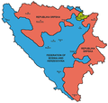
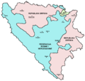
Datoteka:Map Bih entities.png

Veličina ovog prikaza: 633 × 599 piksela. Ostale rezolucije: 254 × 240 piksela | 507 × 480 piksela | 811 × 768 piksela | 1.103 × 1.044 piksela.
Izvorna datoteka (1.103 × 1.044 piksela, veličina datoteke: 67 KB, MIME tip: image/png)
Historija datoteke
Kliknite na datum/vrijeme da vidite verziju datoteke iz tog vremena.
| Datum/vrijeme | Smanjeni pregled | Dimenzije | Korisnik | Komentar | |
|---|---|---|---|---|---|
| trenutno | 23:38, 6 juli 2010 |  | 1.103 × 1.044 (67 KB) | PANONIAN | Reverted to version as of 23:51, 12 March 2010 - I do not agree that these are better colours. it is subjective opinion and it is bad idea that every user should upload new file version because he have different opinion about "better" colours |
| 14:26, 6 juli 2010 |  | 1.103 × 1.044 (58 KB) | Mostarac | better colors | |
| 14:25, 6 juli 2010 |  | 1.103 × 1.044 (58 KB) | Mostarac | better colors and cities. | |
| 01:51, 13 mart 2010 |  | 1.103 × 1.044 (67 KB) | Dungodung | Well, I beg to differ. This one shows cities and is of better quality | |
| 13:55, 9 mart 2010 |  | 700 × 615 (172 KB) | Mostarac | revert, bolje boje! | |
| 23:10, 20 decembar 2009 |  | 1.103 × 1.044 (67 KB) | PANONIAN | improved version | |
| 10:05, 16 juli 2007 |  | 700 × 615 (13 KB) | Nihad Hamzic | This image was once a JPEG, the author had simply directly converted it to JPEG. I have grealty optimised its size by removing JPEG artifacts, and reducing color domain. | |
| 00:42, 29 januar 2006 |  | 700 × 615 (172 KB) | (:Julien:) | Map of the 2 entities of the BiH and the Brčko district, author: en:User:PANONIAN, source: en:Image:M_bih03.png, PANONIAN is the creator and released it under PD. Category:Bosnia and Herzegovina |
Upotreba datoteke
Sljedeće 3 stranice koriste ovu datoteku:
Globalna upotreba datoteke
Sljedeći wikiji koriste ovu datoteku:
- Upotreba na af.wikipedia.org
- Upotreba na ami.wikipedia.org
- Upotreba na am.wikipedia.org
- Upotreba na arc.wikipedia.org
- Upotreba na ar.wikipedia.org
- Upotreba na arz.wikipedia.org
- Upotreba na ast.wikipedia.org
- Upotreba na az.wikipedia.org
- Upotreba na bat-smg.wikipedia.org
- Upotreba na be-tarask.wikipedia.org
- Upotreba na bi.wikipedia.org
- Upotreba na bjn.wikipedia.org
- Upotreba na bn.wikipedia.org
- Upotreba na bo.wikipedia.org
- Upotreba na bpy.wikipedia.org
- Upotreba na br.wikipedia.org
- Upotreba na ca.wikipedia.org
- Upotreba na ceb.wikipedia.org
- Upotreba na ce.wikipedia.org
- Upotreba na ckb.wikipedia.org
- Upotreba na co.wikipedia.org
- Upotreba na crh.wikipedia.org
- Upotreba na csb.wikipedia.org
- Upotreba na cs.wikipedia.org
- Upotreba na cs.wikinews.org
- Upotreba na cv.wikipedia.org
- Upotreba na cy.wikipedia.org
- Upotreba na da.wikipedia.org
- Upotreba na de.wikipedia.org
- Upotreba na diq.wikipedia.org
- Upotreba na dv.wikipedia.org
- Upotreba na ee.wikipedia.org
- Upotreba na el.wikipedia.org
- Upotreba na en.wikipedia.org
- Bosnia and Herzegovina
- History of Bosnia and Herzegovina
- Multinational state
- Republika Srpska (1992–1995)
- Inter-Entity Boundary Line
- Talk:Inter-Entity Boundary Line
- Portal:Bosnia and Herzegovina
- User:Jonny-mt/Gallery of current first-level administrative country subdivisions maps
- Politics of country subdivisions
- Talk:Federation of Bosnia and Herzegovina/Archive 1
- Upotreba na en.wikivoyage.org
- Upotreba na eo.wikipedia.org
- Upotreba na eo.wikivoyage.org
- Upotreba na et.wikipedia.org
Pogledajte globalne upotrebe ove datoteke.


