
Datoteka:Map at millstaetter see.svg

Veličina ovog PNG pregleda za ovu SVG datoteku: 800 × 453 piksela. Ostale rezolucije: 320 × 181 piksela | 640 × 363 piksela | 1.024 × 580 piksela | 1.280 × 725 piksela | 2.560 × 1.451 piksela | 1.313 × 744 piksela.
Izvorna datoteka (SVG datoteka, nominalno 1.313 × 744 piksela, veličina datoteke: 124 KB)
| Ova datoteka je s Wikimedia Commonsa. Opis s njene stranice opisa datoteke prikazan je ispod. Commons je skladište slobodnih medija i datoteka za sve projekte fondacije Wikimedia. Možete i Vi pomoći. |
| Opis |
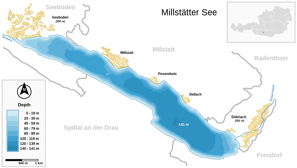
Deutsch: Millstätter See (Kärnten, Österreich) und wichtigste Ortschaften Seeboden / Millstatt / Pesenthein / Dellach / Döbriach
English: Millstätter See (Carinthia, Austria) with surrounding towns.
Français : Carte du lac Millstätter (Carinthie, Autriche) et des villes qui l'entourent. |
| Datum | |
| Izvor | |
| Autor | Michael Glanznig (Mglanznig) |
| Dopuštenje (Naknadno korištenje ove datoteke) |
Creative Commons Attribution ShareAlike 2.0 Austria |
| Ostale verzije | png |
| SVG genesis | This map is translated using SVG switch elements: all translations are stored in the same file. |
| Camera location | | View this and other nearby images on: OpenStreetMap |
|---|
|

This image was selected as picture of the day on Wikimedia Commons for 4 August 2006. It was captioned as follows: Other languages:
Cymraeg: Y Llyn Millstät (Millstätter See) (Carinthia, Awstria) gyda'i threfau amgylchoedd. Magyar: A Millstatti-tó (Karinthia, Ausztria) a környező falvakkal. Polski: Mapa Millstätter See (Karyntia, Austria) wraz z otaczającymi je miastami. Português: Millstätter See (Caríntia, Áustria) e cidades circundantes.. Русский: Мильшттское озеро (Millstätter See) в Каринтии, в Австрии: схема озера с прилежащими городами العربية : بحيرة ميلستيتير (كارينثيا النمسا) و البلدات المحيطة. |
Ja, vlasnik autorskog prava ovog djela, ovdje ga objavljujem pod sljedećom licencom:
Ova datoteka je licencirana pod Creative Commons licencom Attribution-Share Alike 2.0 Austrija.
- Slobodni ste:
- da dijelite – da kopirate, distributirate i prenosite djelo
- da remiksate – da prilagodite djelo
- Pod sljedećim uslovima:
- pripisivanje – Morate pripisati odgovarajuće autorske zasluge, osigurati link ka licenci i naznačiti jesu li napravljene izmjene. To možete uraditi na bilo koji razumni način, ali ne tako da se sugerira da davalac licence odobrava Vas ili Vašu upotrebu njegovog djela.
- dijeli pod istim uslovima – Ako mijenjate, transformišete ili nadograđujete ovaj materijal, morate ga objaviti i distribuirati samo pod istom ili sličnom licencom poput ove.

Historija datoteke
Kliknite na datum/vrijeme da vidite verziju datoteke iz tog vremena.
| Datum/vrijeme | Smanjeni pregled | Dimenzije | Korisnik | Komentar | |
|---|---|---|---|---|---|
| trenutno | 12:04, 27 mart 2021 | | 1.313 × 744 (124 KB) | JoKalliauer | 1) width="1050pt" height="210mm" undefined behaviour (90 or 96 dpi) ; 2)<sodipodi:namedview pagecolor="#ffffff" replaced with <circle r="1e4" fill="#ffffff"/> and <rect width="100%" height="100%" fill="#ffffff"/>; 3) fonts replaced by fallback-fonts |
| 20:47, 10 juni 2019 |  | 1.313 × 744 (239 KB) | Djiboun | File uploaded using svgtranslate tool (http://tools.wmflabs.org/svgtranslate/). Added translation for fr. | |
| 12:01, 16 april 2006 |  | 1.313 × 744 (238 KB) | Mglanznig | names for creeks | |
| 09:50, 15 april 2006 |  | 1.313 × 744 (236 KB) | Mglanznig | refinements | |
| 23:06, 13 april 2006 |  | 1.313 × 744 (233 KB) | Mglanznig | more svg rendering errors, praise Inkscape | |
| 22:43, 13 april 2006 |  | 1.313 × 744 (237 KB) | Mglanznig | svg errors corrected | |
| 22:35, 13 april 2006 |  | 1.313 × 744 (236 KB) | Mglanznig | ;Description : {{de|Millstätter See und wichtigste Ortschaften, Kärnten, Österreich}} {{en|Millstätter See with main towns, Carinthia, Austria}} ;Source : {{de|selbst zusammengestellt; Geodaten von [http://www.map24.com Map24] und [http://www.kagis.kt |
Upotreba datoteke
Nema stranica koje koriste ovu datoteku.
Globalna upotreba datoteke
Sljedeći wikiji koriste ovu datoteku:
- Upotreba na arz.wikipedia.org
- Upotreba na be.wikipedia.org
- Upotreba na ceb.wikipedia.org
- Upotreba na de.wikipedia.org
- Upotreba na el.wikipedia.org
- Upotreba na en.wikipedia.org
- Upotreba na eo.wikipedia.org
- Upotreba na fr.wikipedia.org
- Upotreba na hu.wikipedia.org
- Upotreba na hy.wikipedia.org
- Upotreba na ia.wikipedia.org
- Upotreba na id.wikipedia.org
- Upotreba na ko.wikipedia.org
- Upotreba na lv.wikipedia.org
- Upotreba na nl.wikipedia.org
- Upotreba na nl.wikibooks.org
- Upotreba na nn.wikipedia.org
- Upotreba na pl.wikipedia.org
- Upotreba na pt.wikipedia.org
- Upotreba na ru.wikipedia.org
- Upotreba na ru.wikinews.org
- Upotreba na su.wikipedia.org
- Upotreba na uk.wikipedia.org
- Upotreba na www.wikidata.org