
Datoteka:New Guinea (1884-1919).png
Veća rezolucija nije dostupna.
New_Guinea_(1884-1919).png (618 × 319 piksela, veličina datoteke: 60 KB, MIME tip: image/png)
| Ova datoteka je s Wikimedia Commonsa. Opis s njene stranice opisa datoteke prikazan je ispod. Commons je skladište slobodnih medija i datoteka za sve projekte fondacije Wikimedia. Možete i Vi pomoći. |
.png)

|
This map image could be re-created using vector graphics as an SVG file. This has several advantages; see Commons:Media for cleanup for more information. If an SVG form of this image is available, please upload it and afterwards replace this template with
{{vector version available|new image name}}.
It is recommended to name the SVG file “New Guinea (1884-1919).svg”—then the template Vector version available (or Vva) does not need the new image name parameter. |
Sažetak
| Opis |
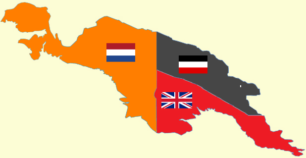
English: Political map of the island of New Guinea from 1884-1919. |
| Datum | |
| Izvor |
Own work based on: Supporting references:
|
| Autor | Cartol |
Licenciranje

|
Dozvoljeno je kopirati, distribuirati i/ili mijenjati ovaj članak pod uslovima navedenim u GNU licenci za slobodnu dokumentaciju, verzija 1.2 ili kasnijom verzijom izdatom od Free Software Foundation; bez nepromjenljivih dijelova, te bez sadržaja na naslovnoj i zadnjoj strani. Kopija licence se nalazi pod poglavljem GNU Free Documentation License. |
| Ova datoteka je licencirana pod Creative Commons Attribution-Share Alike 3.0 neportiranom licencom. | ||
| ||
| Ova oznaka licence je dodana na ovu datoteku kao dio GFDL ažuriranja licence. |
|
|
This flag map image could be re-created using vector graphics as an SVG file. This has several advantages; see Commons:Media for cleanup for more information. If an SVG form of this image is available, please upload it and afterwards replace this template with
{{vector version available|new image name}}.
It is recommended to name the SVG file “New Guinea (1884-1919).svg”—then the template Vector version available (or Vva) does not need the new image name parameter. |
Historija datoteke
Kliknite na datum/vrijeme da vidite verziju datoteke iz tog vremena.
| Datum/vrijeme | Smanjeni pregled | Dimenzije | Korisnik | Komentar | |
|---|---|---|---|---|---|
| trenutno | 01:38, 23 septembar 2009 | | 618 × 319 (60 KB) | Jayen466 | Content changes as described in previous edit, but this time in png format. The previous edit did not take, probably because I tried to upload in jpg format rather than png. |
| 01:32, 23 septembar 2009 |  | 618 × 319 (87 KB) | Jayen466 | Adjusted the border between Kaiser-Wilhelmsland and British Papua in Photoshop, based on the more reliable map at http://upload.wikimedia.org/wikipedia/commons/4/4e/Map-Kaiser-Wilhelms-Land-und-Bismarck-Archipel.png – according to several contemporary R | |
| 06:47, 10 juli 2008 |  | 618 × 319 (25 KB) | Cartol | {{Information |Description=Political map of the island of New Guinea from 1884-1919. |Source=Self-created map. Outline of New Guinea based on Image:New guinea named.PNG. Flags from Image:Flag of the United Kingdom.svg, [[:Image:Flag of the Neth |
Upotreba datoteke
Sljedeća stranica koristi ovu datoteku:
Globalna upotreba datoteke
Sljedeći wikiji koriste ovu datoteku:
- Upotreba na af.wikipedia.org
- Upotreba na als.wikipedia.org
- Upotreba na ar.wikipedia.org
- Upotreba na ast.wikipedia.org
- Upotreba na be-tarask.wikipedia.org
- Upotreba na be.wikipedia.org
- Upotreba na ca.wikipedia.org
- Upotreba na cbk-zam.wikipedia.org
- Upotreba na cs.wikipedia.org
- Upotreba na de.wikipedia.org
- Upotreba na en.wikipedia.org
- History of Oceania
- Oceania
- Papua New Guinea
- Kaiser-Wilhelmsland
- New Guinea
- Postage stamps and postal history of Papua New Guinea
- Hermann Detzner
- Talk:Hermann Detzner
- User:Cruickshanks/Sandbox
- User:Cruickshanks/sandbox3
- User:Cruickshanks/sandbox4
- The Ballad of the Salty Sea
- Indonesia–Papua New Guinea border
- Portal:New Guinea
- Upotreba na es.wikipedia.org
- Upotreba na eu.wikipedia.org
- Upotreba na fa.wikipedia.org
- Upotreba na fi.wikipedia.org
Pogledajte globalne upotrebe ove datoteke.
.png)
.png)