
Datoteka:Pan-European corridors.svg

Veličina ovog PNG pregleda za ovu SVG datoteku: 392 × 486 piksela. Ostale rezolucije: 193 × 240 piksela | 387 × 480 piksela | 619 × 768 piksela | 826 × 1.024 piksela | 1.652 × 2.048 piksela.
Izvorna datoteka (SVG datoteka, nominalno 392 × 486 piksela, veličina datoteke: 561 KB)
| Ova datoteka je s Wikimedia Commonsa. Opis s njene stranice opisa datoteke prikazan je ispod. Commons je skladište slobodnih medija i datoteka za sve projekte fondacije Wikimedia. Možete i Vi pomoći. |
Sažetak
| Opis |
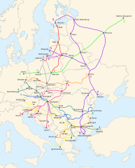
English: Map of the ten Pan-European transport corridors. |
| Datum | (UTC) |
| Izvor | |
| Autor |
|
| Ostale verzije |
|
| SVG genesis |


Licenciranje
Ova datoteka je licencirana pod Creative Commons Attribution-Share Alike 3.0 neportiranom licencom.
- Slobodni ste:
- da dijelite – da kopirate, distributirate i prenosite djelo
- da remiksate – da prilagodite djelo
- Pod sljedećim uslovima:
- pripisivanje – Morate pripisati odgovarajuće autorske zasluge, osigurati link ka licenci i naznačiti jesu li napravljene izmjene. To možete uraditi na bilo koji razumni način, ali ne tako da se sugerira da davalac licence odobrava Vas ili Vašu upotrebu njegovog djela.
- dijeli pod istim uslovima – Ako mijenjate, transformišete ili nadograđujete ovaj materijal, morate ga objaviti i distribuirati samo pod istom ili sličnom licencom poput ove.
Originalni zapisnik postavljanja
This image is a derivative work of the following images:
- File:Blank_map_of_Europe_-_Atelier_graphique_colors.svg licensed with Cc-by-sa-2.5,2.0,1.0, Cc-by-sa-2.5,2.0,1.0/en, GFDL, GFDL/en
- 2008-09-23T18:46:08Z Antigoni 841x731 (498781 Bytes) Montenegro update
- 2007-09-16T15:08:27Z Historicair 841x731 (495651 Bytes)
- 2007-09-13T16:36:42Z Historicair 841x731 (495370 Bytes) {{Information |Description={{fr|Carte vierge de l'Europe, couleurs Atelier Graphique}} {{en|Blank map of Europe with Atelier graphique colors}} |Source=[[:Image:Europe countries.svg]] by [[User:Tintazul|Tintazul]] |Date=13/09
- File:Paneuropetransport.png licensed with PD-self, PD-self/en
- 2007-10-18T08:05:36Z Hoshie 773x942 (45202 Bytes) added Montenegro. Under same lic. as before.
- 2006-12-12T23:11:56Z Albinfo 773x942 (37476 Bytes) Fixed several errors and updated corrections in the original file - sorry for all the misleadings
- 2006-12-05T20:06:34Z Geo-Loge 773x941 (33896 Bytes) Ostrava => Brno, Ostrava added, Wroclaw and Krakow added
- 2006-06-24T17:12:35Z Joy 773x941 (28882 Bytes) Fixed confusion between Lviv and Uzhorod.
- 2005-12-30T22:42:00Z Albinfo 773x941 (37167 Bytes) The ten Pan-European transport corridors. Created by [[User:Albinfo]] using [[User:wiki-vr]]'s [[:Image:Europe_blank_map.png|blank map]].
Uploaded with derivativeFX
Historija datoteke
Kliknite na datum/vrijeme da vidite verziju datoteke iz tog vremena.
| Datum/vrijeme | Smanjeni pregled | Dimenzije | Korisnik | Komentar | |
|---|---|---|---|---|---|
| trenutno | 23:16, 25 februar 2018 | | 392 × 486 (561 KB) | Nameless23 | Fixed the spelling of Kaliningrad and Nizhny Novgorod. |
| 01:55, 4 novembar 2009 |  | 392 × 486 (561 KB) | Joy | {{Information |Description={{en|Map of the ten Pan-European transport corridors.}} |Source=*File:Pan-European_corridors.svg |Date=2009-11-03 23:54 (UTC) |Author=*File:Pan-European_corridors.svg: *[[:File:Blank_map_of_Europe_-_Atelier_graphique | |
| 01:46, 4 februar 2009 |  | 392 × 486 (554 KB) | Honza.havlicek | {{Information |Description={{en|Map of the ten Pan-European transport corridors.}} |Source=*File:Blank_map_of_Europe_-_Atelier_graphique_colors.svg *File:Paneuropetransport.png |Date=2009-02-03 23:39 (UTC) |Author=*[[:File:Blank_map_of_Europe_ |
Upotreba datoteke
Sljedeća stranica koristi ovu datoteku:
Globalna upotreba datoteke
Sljedeći wikiji koriste ovu datoteku:
- Upotreba na ar.wikipedia.org
- Upotreba na bg.wikipedia.org
- Upotreba na en.wikipedia.org
- Upotreba na fr.wikipedia.org
- Upotreba na he.wikipedia.org
- Upotreba na hr.wikipedia.org
- Upotreba na hu.wikipedia.org
- Upotreba na id.wikipedia.org
- Upotreba na it.wikipedia.org
- Upotreba na ja.wikipedia.org
- Upotreba na ko.wikipedia.org
- Upotreba na nl.wikipedia.org
- Upotreba na no.wikipedia.org
- Upotreba na pl.wikipedia.org
- Upotreba na ro.wikipedia.org
- Upotreba na ru.wikipedia.org
- Upotreba na sk.wikipedia.org
- Upotreba na sl.wikipedia.org
- Upotreba na sq.wikipedia.org
- Upotreba na uk.wikipedia.org
- Upotreba na www.wikidata.org