
Datoteka:Seas of the Philippines.svg

Veličina ovog PNG pregleda za ovu SVG datoteku: 318 × 600 piksela. Ostale rezolucije: 127 × 240 piksela | 254 × 480 piksela | 407 × 768 piksela | 543 × 1.024 piksela | 1.086 × 2.048 piksela | 2.106 × 3.971 piksela.
Izvorna datoteka (SVG datoteka, nominalno 2.106 × 3.971 piksela, veličina datoteke: 517 KB)
| Ova datoteka je s Wikimedia Commonsa. Opis s njene stranice opisa datoteke prikazan je ispod. Commons je skladište slobodnih medija i datoteka za sve projekte fondacije Wikimedia. Možete i Vi pomoći. |
Sažetak
| Opis |
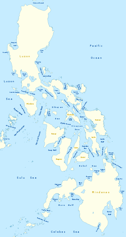
Deutsch: Karte der Seegewässer der Philippinen
English: Map of seas of the Philippines |
|
| Datum | ||
| Izvor | Vlastito djelo, using United States National Imagery and Mapping Agency data | |
| Autor | NordNordWest | |
| Dopuštenje (Naknadno korištenje ove datoteke) |
Ova datoteka je licencirana pod Creative Commons licencom Attribution-Share Alike 3.0 Njemačka.
 Ova datoteka je licencirana pod Creative Commons Attribution-Share Alike 3.0 neportiranom licencom.
|
|
| Ostale verzije |
|


|
This map has been made or improved in the German Kartenwerkstatt (Map Lab). You can propose maps to improve as well.
|
Historija datoteke
Kliknite na datum/vrijeme da vidite verziju datoteke iz tog vremena.
| Datum/vrijeme | Smanjeni pregled | Dimenzije | Korisnik | Komentar | |
|---|---|---|---|---|---|
| trenutno | 23:25, 14 februar 2011 | | 2.106 × 3.971 (517 KB) | NordNordWest | == {{int:filedesc}} == {{Information |Description= {{de|Karte der Seegewässer der Philippinen}} {{en|Map of seas of the Philippines}} |Source={{Own}}, using United States National Imagery and Mapping Agency data |Date=2012-02-14 |Author={{U|NordNordWest |
Upotreba datoteke
Nema stranica koje koriste ovu datoteku.
Globalna upotreba datoteke
Sljedeći wikiji koriste ovu datoteku:
- Upotreba na de.wikipedia.org
- Upotreba na en.wikipedia.org
- South China Sea
- Luzon Strait
- Leyte Gulf
- Philippine Sea
- Canigao Channel
- Cebu Strait
- Sulu Sea
- Moro Gulf
- Davao Gulf
- Panay Gulf
- Bohol Sea
- Lingayen Gulf
- Surigao Strait
- Celebes Sea
- Sibuyan Sea
- Visayan Sea
- San Juanico Strait
- San Bernardino Strait
- Balintang Channel
- Camotes Sea
- Samar Sea
- Ragay Gulf
- Lagonoy Gulf
- Sorsogon Bay
- Albay Gulf
- Tablas Strait
- Mindoro Strait
- Balabac Strait
- Verde Island Passage
- Sibutu Passage
- Jintotolo Channel
- Tañon Strait
- Dinagat Sound
- Template:List of Philippine seas
- Iloilo Strait
- Guimaras Strait
- Basilan Strait
- Maqueda Channel
- Burias Pass
- Ticao Pass
- Upotreba na ilo.wikipedia.org
Pogledajte globalne upotrebe ove datoteke.