
Datoteka:Serbia in the Yugoslav Wars.png
Veličina ovog prikaza: 800 × 555 piksela. Ostale rezolucije: 320 × 222 piksela | 640 × 444 piksela | 1.024 × 711 piksela | 1.285 × 892 piksela.
Izvorna datoteka (1.285 × 892 piksela, veličina datoteke: 130 KB, MIME tip: image/png)
| Ova datoteka je s Wikimedia Commonsa. Opis s njene stranice opisa datoteke prikazan je ispod. Commons je skladište slobodnih medija i datoteka za sve projekte fondacije Wikimedia. Možete i Vi pomoći. |

|
This military map image could be re-created using vector graphics as an SVG file. This has several advantages; see Commons:Media for cleanup for more information. If an SVG form of this image is available, please upload it and afterwards replace this template with
{{vector version available|new image name}}.
It is recommended to name the SVG file “Serbia in the Yugoslav Wars.svg”—then the template Vector version available (or Vva) does not need the new image name parameter. |
Sažetak
| Opis |
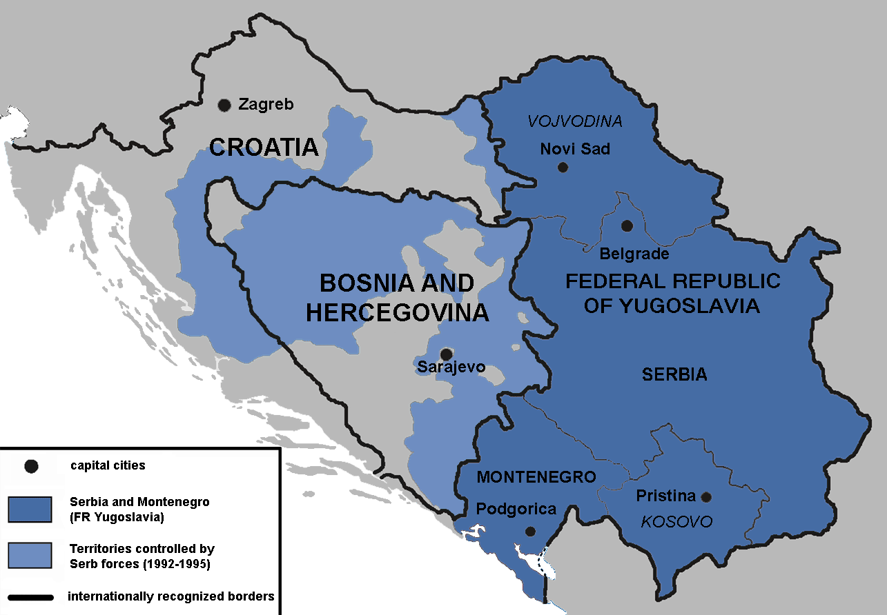
English: Territories of the Republic of Bosnia and Herzegovina and the Republic of Croatia controlled by the Serb forces, after the Operation Corridor (July 1992) in the Yugoslav Wars.
According to the prosecution of War Crimes Tribunal, "Serbian forces" included Yugoslav Army, Serb Territorial Defense of Bosnia and Herzegovina and Croatia, Republic of Srpska Krajina Army, Army of the Republika Srpska, territorial defense of Serbia and Montenegro, Police of Serbia and Police of Republika Srpska, including national security, special police forces of Krajina known as "Martićevci", as well as all Serbian paramilitary forces and volunteer units.[1] Croatia declared independence on June 25, 1991. It was internationally recognized on 15 January 1992 by the United Nations. Bosnia and Herzegovina declared independence on March 5 1992. It was internationally recognized on 22 May 1992 by the United Nations. Serbia and Montenegro proclaimed FR Yugoslavia as a sole successor state of SFR Yugoslavia, on April 27 1992. It remained unrecognized during the conflict (1991-1995). |
||
| Datum | |||
| Izvor | Vlastito djelo | ||
| Autor | Mladifilozof | ||
| Dopuštenje (Naknadno korištenje ove datoteke) |
Ja, vlasnik autorskog prava ovog djela, ovdje ga objavljujem pod sljedećim licencama: Ova datoteka je licencirana pod Creative Commons Attribution-Share Alike 3.0 neportiranom licencom.
Možete odabrati licencu po vašem izboru. |
||
| Ostale verzije |
|


- ↑ Šešelj ICTY Case information sheet (retrieved 10.07.2009.)
Historija datoteke
Kliknite na datum/vrijeme da vidite verziju datoteke iz tog vremena.
| Datum/vrijeme | Smanjeni pregled | Dimenzije | Korisnik | Komentar | |
|---|---|---|---|---|---|
| trenutno | 18:09, 13 januar 2019 | | 1.285 × 892 (130 KB) | Illegitimate Barrister | labelled FRoY |
| 01:50, 12 august 2012 |  | 1.285 × 892 (106 KB) | DIREKTOR | Small fix | |
| 02:14, 3 april 2012 |  | 1.285 × 892 (76 KB) | Phoenix B 1of3 | The blue map appears clearer and easier to understand | |
| 13:34, 2 april 2012 |  | 1.285 × 892 (83 KB) | Fezz5555 | Returning the original previous image of the author. | |
| 01:27, 11 decembar 2011 |  | 1.285 × 892 (76 KB) | DIREKTOR | Colour | |
| 06:12, 22 februar 2010 |  | 1.285 × 892 (83 KB) | Mladifilozof | improved | |
| 22:24, 16 februar 2010 |  | 1.285 × 892 (89 KB) | Mladifilozof | {{Information |Description={{en|1=Territories of the Republic of Bosnia and Herzegovina and the Republic of Croatia controlled by the Serbian forces during the [[:en:Yugoslav Wars|Yugo |
Upotreba datoteke
Sljedeće 2 stranice koriste ovu datoteku:
Globalna upotreba datoteke
Sljedeći wikiji koriste ovu datoteku:
- Upotreba na ar.wikipedia.org
- Upotreba na azb.wikipedia.org
- Upotreba na az.wikipedia.org
- Upotreba na be.wikipedia.org
- Upotreba na bg.wikipedia.org
- Upotreba na ca.wikipedia.org
- Upotreba na cs.wikipedia.org
- Upotreba na da.wikipedia.org
- Upotreba na de.wikipedia.org
- Upotreba na el.wikipedia.org
- Upotreba na en.wikipedia.org
- Siege of Sarajevo
- Greater Serbia
- Bosnian genocide
- Republika Srpska (1992–1995)
- Talk:Republika Srpska (1992–1995)
- Croatian War of Independence
- Talk:Joint criminal enterprise
- Talk:Republic of Bosnia and Herzegovina
- Talk:Bosnian War/Archive 3
- Serbia in the Yugoslav Wars
- Talk:Republic of Serbian Krajina/Archive 3
- Talk:Bosnian genocide/Archive 4
- Wikipedia:Graphics Lab/Map workshop/Archive/Oct 2011
- User:Phoenix B 1of3/Stop Greater Serbia
- Talk:Slobodan Milošević/Archive 2
- Talk:Siege of Sarajevo/Archive 1
- Agreement on Friendship and Cooperation between Bosnia and Herzegovina and Croatia
- Talk:Operation Corridor 92/Archive 1
- Proposed secession of Republika Srpska
- User:Falcaorib
- Talk:History of Serbia/Archive 1
- Talk:Republic of Serbia (1992–2006)/Archive 1
- Talk:Russia/Archive 16
- Upotreba na es.wikipedia.org
- Upotreba na eu.wikipedia.org
- Upotreba na fr.wikipedia.org
- Upotreba na gl.wikipedia.org
- Upotreba na he.wikipedia.org
- Upotreba na hr.wikipedia.org
Pogledajte globalne upotrebe ove datoteke.