
Datoteka:Tabula hungariae.jpg

Veličina ovog prikaza: 421 × 600 piksela. Ostale rezolucije: 168 × 240 piksela | 337 × 480 piksela | 539 × 768 piksela | 719 × 1.024 piksela | 1.438 × 2.048 piksela | 3.236 × 4.609 piksela.
Izvorna datoteka (3.236 × 4.609 piksela, veličina datoteke: 3,27 MB, MIME tip: image/jpeg)
| Ova datoteka je s Wikimedia Commonsa. Opis s njene stranice opisa datoteke prikazan je ispod. Commons je skladište slobodnih medija i datoteka za sve projekte fondacije Wikimedia. Možete i Vi pomoći. |
Sažetak
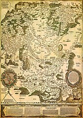
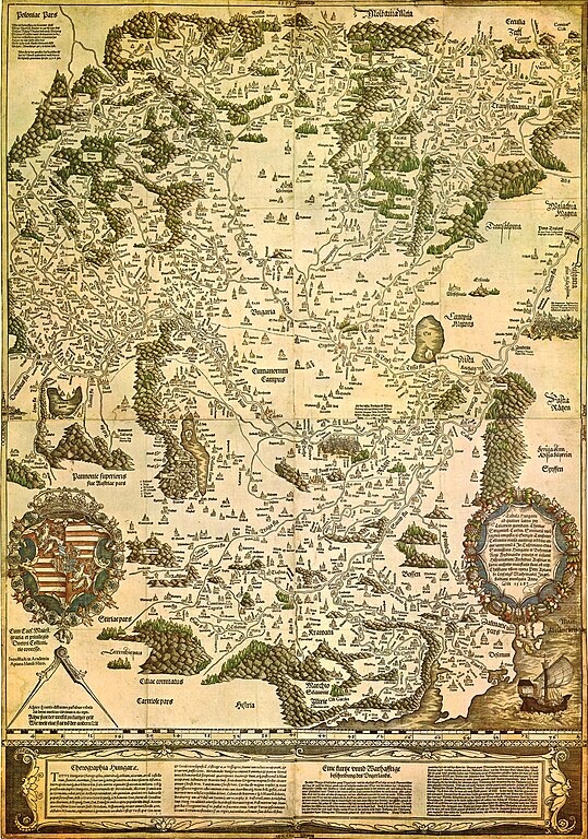
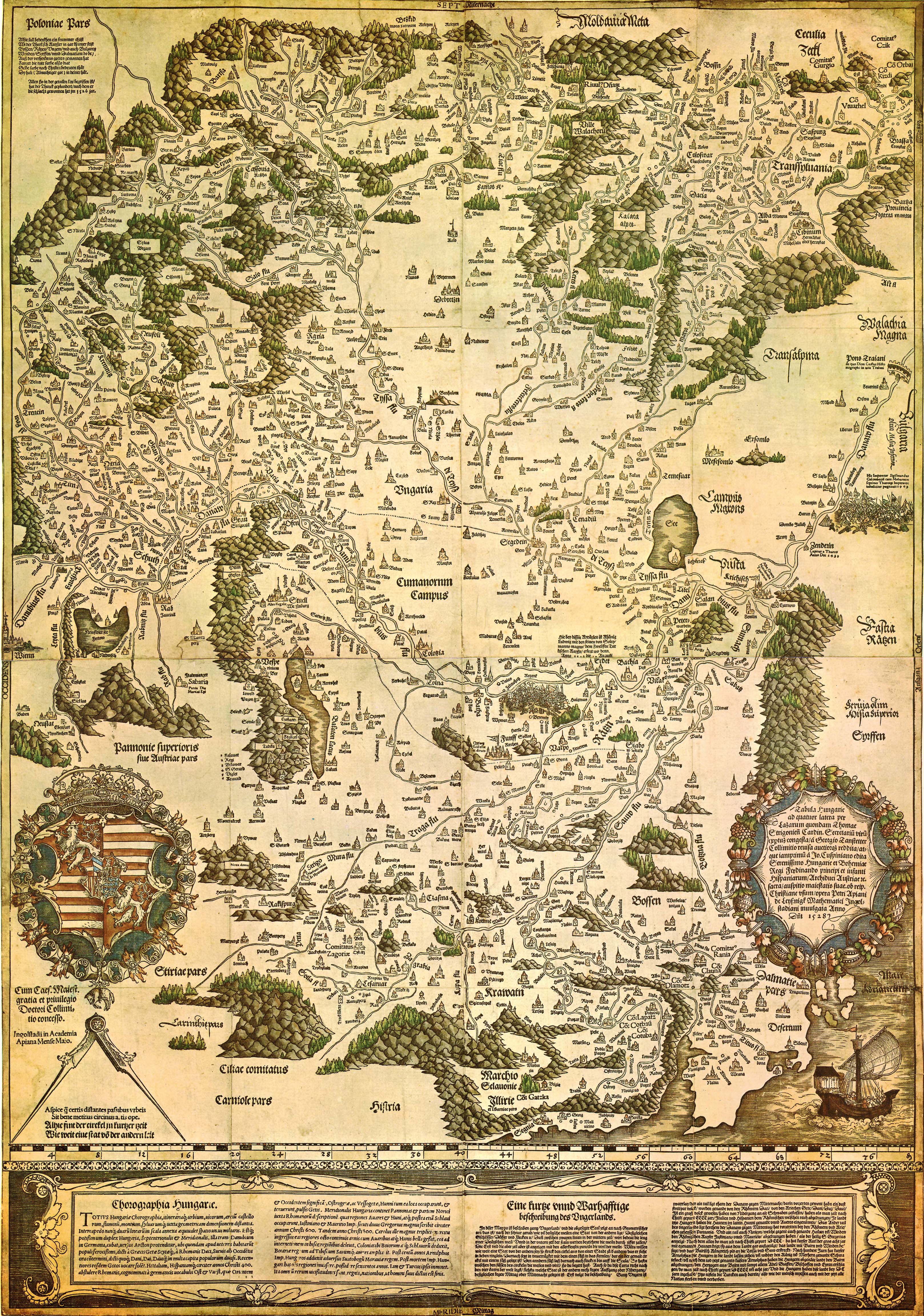
| Tabula Hungariae
|
|||||||||||||||||||||
|---|---|---|---|---|---|---|---|---|---|---|---|---|---|---|---|---|---|---|---|---|---|
| Autor |
Lázár deák (Lazarus secretarius) |
 | |||||||||||||||||||
| Title |
latinski: Tabula Hungarie ad quatuor latera Tabula Hungariae |
||||||||||||||||||||
| Štamparija | |||||||||||||||||||||
| Object type |
antique map |
||||||||||||||||||||
| Opis |
Magyar: A Tabula Hungariae vagy Lázár térképe Magyarország első nyomtatott térképe, amelyet a feltehetően a magyar Lázár deák készített Српски / srpski: Lazarusova karta Ugarske iz 1528. godine na kojoj je na mestu današnjeg Novog Sada ubeleženo naselje Bistritz (Bistrica) |
||||||||||||||||||||
| Datum | 1526 - 1528 | ||||||||||||||||||||
| Datum objavljivanja |
1528 |
||||||||||||||||||||
| Kolekcija |
|
||||||||||||||||||||
| References | |||||||||||||||||||||
| Kontrola autoriteta | |||||||||||||||||||||
| Source/Photographer | http://lazarus.elte.hu/hun/maps/lazar150.jpg | ||||||||||||||||||||
| Ostale verzije |
|
||||||||||||||||||||


Licenciranje
|
This work is in the public domain in its country of origin and other countries and areas where the copyright term is the author's life plus 100 years or fewer. This work is in the public domain in the United States because it was published (or registered with the U.S. Copyright Office) before January 1, 1929. | |
| Ova datoteka je identificirana kao slobodna od poznatih ograničenja po zakonu o autorskim pravima, uključujući sva povezana i srodna prava. | |
Historija datoteke
Kliknite na datum/vrijeme da vidite verziju datoteke iz tog vremena.
| Datum/vrijeme | Smanjeni pregled | Dimenzije | Korisnik | Komentar | |
|---|---|---|---|---|---|
| trenutno | 01:02, 30 august 2009 | | 3.236 × 4.609 (3,27 MB) | Qorilla | {{Information |Description={{en|1=Tabula Hungariae, first printed map of Hungary}} |Source=Hungarian Wikipedia |Author=Lázár deák (Lazarus secretarius) |Date=somewhere between 1526-1528 |Permission= |other_versions= }} Category:Old maps of Hungary |
Upotreba datoteke
Sljedeće 3 stranice koriste ovu datoteku:
Globalna upotreba datoteke
Sljedeći wikiji koriste ovu datoteku:
- Upotreba na ar.wikipedia.org
- Upotreba na bn.wikipedia.org
- Upotreba na ca.wikipedia.org
- Upotreba na de.wikipedia.org
- Upotreba na el.wikipedia.org
- Upotreba na en.wikipedia.org
- Pannonia
- Treaty of Trianon
- Hungarian Revolution of 1956
- Austro-Hungarian Compromise of 1867
- Military Frontier
- Hungarian nobility
- History of Hungary before the Hungarian conquest
- Hungarian prehistory
- Kingdom of Hungary (1526–1867)
- History of geography
- Georg Tannstetter
- Upper Hungary
- History of the Jews in Hungary
- Music history of Hungary
- Bistrica, Novi Sad
- Lands of the Crown of Saint Stephen
- History of Transylvania
- Template:History of Hungary
- Hungarian People's Republic
- Principality of Transylvania (1570–1711)
- Military history of Hungary
- First Hungarian Republic
- Ottoman Hungary
- Hungary between the World Wars
- Principality of Hungary
- Hungarian Revolution of 1848
- Rákóczi's War of Independence
- Eastern Hungarian Kingdom
- Kingdom of Hungary (1920–1946)
- Hungary in World War I
- Second Hungarian Republic
- Mugel
- Tabula Hungariae
- History of Hungary
Pogledajte globalne upotrebe ove datoteke.